• Welcome to TalkWeather!
    We see you lurking around TalkWeather! Take the extra step and join us today to view attachments, see less ads and maybe even join the discussion.
    CLICK TO JOIN TALKWEATHER

Severe Weather Threat May 17-19, 2025

So, why would that one not drop a violent tornado? Just saying it now…to me, it has no reason not too. So if it doesn’t, I’ll be very confused.
Supposedly, it's entering into an environment that should be more hostile to tornado development. We shall see how accurate that is, though...
 
Supposedly, it's entering into an environment that should be more hostile to tornado development. We shall see how accurate that is, though...
Even if it is entering a hostile environment, well-established supercells are capable of withstanding bad environments for a while. This was the case with the Greensburg cell in 2007 and the West Liberty cell from 2012.
 
Wow. I was gone for a bit, but I've just seen the Grinnell, KS pics. Very bad. I apologize for my misinformation earlier on the tornado dissipating prior to reaching town. Hopefully there were no serious injuries or worse from that tornado.
You're all good, it really did look like it had missed town on radar. Not exactly sure what happened.
 
Even if it is entering a hostile environment, well-established supercells are capable of withstanding bad environments for a while. This was the case with the Greensburg cell in 2007 and the West Liberty cell from 2012.
IIRC, the 2021 Quad-State Supercell (which produced the Mayfield tornado) also experienced something similar as well.
 
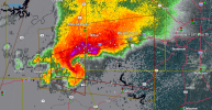
My radar app says at the current speed, the Texas tornado will start to brush the southwestern edge of Ft. Worth in about an hour. If I were in Aledo, Benbrook, or Burleson I'd want to keep a good eye on this. Hell, I'm closer to Lewisville and I'm watching it like a hawk.
 
Per local DFW met


Steve McCauley

3m ·
Although most storms in north Texas are moving to the NE, the one that is rotating the fastest (Level 18 out of 30) is a "right mover" and is moving more due east. This storm in SE Palo Pinto County will be moving into Parker and then Tarrant Counties over the next couple of hours. Radar continues to show a possible tornado just east of Santo, about 17 mi S of Mineral Wells moving E at 25 mph.
The atmosphere over the Metroplex is slightly less unstable than out west, but because the storm is so intense, it may be able to hold on to its severe status at least as it moves into the western half of the Metroplex before beginning a weakening trend.
So stay alert. This storm has had a history of producing hail up to the size of tennis balls and confirmed tornado touchdowns.
 
Back
Top