
Navigation
Install the app
How to install the app on iOS
Follow along with the video below to see how to install our site as a web app on your home screen.
Note: This feature may not be available in some browsers.
More options
-
Welcome to TalkWeather! We see you lurking around TalkWeather! Take the extra step and join us today to view attachments, see less ads and maybe even join the discussion. CLICK TO JOIN TALKWEATHER
You are using an out of date browser. It may not display this or other websites correctly.
You should upgrade or use an alternative browser.
You should upgrade or use an alternative browser.
Severe WX Severe Weather Threat - Jan 2nd - Jan 4th, 2023
- Thread starter Taylor Campbell
- Start date
Dude! I've seen that movie so many times I can quote it word for word. Big Star Wars nerd as well as meteorological nerd.
CheeselandSkies
Member
So far this event is reminding me of the December one, where we had a lot of couplets/some apparently strong, but relatively little in the way of clear significant touchdowns/debris signatures.
CheeselandSkies
Member
Looks like if/when any initiation back along the front in TX/OK gets its act together, it will be well east of the I-35 corridor and the DFW metroplex, so that's good news.
CheeselandSkies
Member
CheeselandSkies
Member
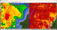
No doubt about it now. 0.5 degree beam is at nearly 6,000' up so that debris is getting up there.
The warning's been given a PDS upgrade as well.
CheeselandSkies
Member
While that cell finally produced, and the warning was extended northward, based on radar structure it's probably about done. I'd watch the ones back west and north of Ft. Polk for the next short-term tornado threat.
Some storms back in eastern Oklahoma have gone severe, but their structure doesn't look stellar for tornado production at least in the near term.
Some storms back in eastern Oklahoma have gone severe, but their structure doesn't look stellar for tornado production at least in the near term.

OHWX97
Member
Eastern Oklahoma is looking real suspicious right about now. The severe storms appear to be growing more organized and supercellular.
Eastern Oklahoma is looking real suspicious right about now. The severe storms appear to be growing more organized and supercellular.
A couple TORs have already been issued in that area now.
CheeselandSkies
Member
LSR just popped up for tree damage just east of Jonesboro, LA.
- Admin
- #174
- Messages
- 3,618
- Reaction score
- 3,431
- Location
- Fayetteville, AR
- Special Affiliations
- SKYWARN® Volunteer
Watching those storms closely.Eastern Oklahoma is looking real suspicious right about now. The severe storms appear to be growing more organized and supercellular.
The National Weather Service in Tulsa has issued a
* Tornado Warning for...
West central Haskell County in southeastern Oklahoma...
Eastern McIntosh County in southeastern Oklahoma...
North central Pittsburg County in southeastern Oklahoma...
* Until 615 PM CST.
* At 530 PM CST, a severe thunderstorm capable of producing a tornado
was located over Canadian, moving northeast at 45 mph.
HAZARD...Tornado and half dollar size hail.
SOURCE...Radar indicated rotation.
IMPACT...Flying debris will be dangerous to those caught without
shelter. Mobile homes will be damaged or destroyed.
Damage to roofs, windows, and vehicles will occur. Tree
damage is likely.
* Locations in or near the path include...
Eufaula... Checotah...
Crowder... Canadian...
Indianola... Rentiesville...
Stidham... Arrowhead State Park...
Lake Eufaula State Park... Vivian...
Onapa...
CheeselandSkies
Member
Yeah, I may eat my words about those OK storms. Eufaula one in particular looks like trouble.
OHWX97
Member
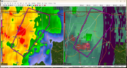
Likely tornado currently passing between Pryor Creek and Adair, OK. Very tight couplet.
TH2002
Member
- Messages
- 4,973
- Reaction score
- 11,113
- Location
- California, United States
- Special Affiliations
- SKYWARN® Volunteer
CC drop

OHWX97
Member
Certainly getting the look of a real troublemaker.

TornadoFan
Member
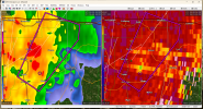
Tight rotation headed for Georgetown, Arkansas.
SmokeEater
Member
Cell heading for W Monroe LA has a nasty couplet.
Sent from my SM-S901U using Tapatalk
Sent from my SM-S901U using Tapatalk