Severe WX Severe Weather Threat - December 8th-10th, 2023

One model runs, and everyone is giving up on this system... I like to see several runs of the NAM3k and HRRR runs before I write it off. Quick spin-up tornadoes from a squall line are just as dangerous. There's no need to blow it off this early in the ball game.
Clearly people don’t understand Dixie Alley lol
 
Still thinking a 10% tornado risk may be warranted with this setup, particularly in the southern half of the current 15% contour in Texas and Louisiana. The Saturday 18z GFS run shows a tornado threat pointed roughly near Columbia, LA - this would seemingly be significantly more dangerous if the shear ends up overperforming:
gfs_2023120618_075_31.75--92.0.png
 
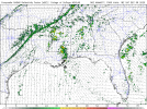
And let's just remember that the EF-0 tornado (pictured below that I just happened to capture on my GoPro 11) that occurred 2 miles west of Smithville, MS on February 16th happened on a Level 3 Enhanced Risk with a 10% SIG TOR hatch. Day 3 was just a Slight Risk.

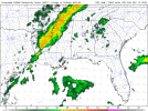
March 24th: Day 3 Enhanced Risk became a Moderate Risk by Day 1. EF-3 Amory, MS happened.

Don't write it off yet. I've made the mistake before writing off an event that ended up producing more than anticipated. Never again.

I honestly don't care what the models show or don't show at this point. Models are a tool to help, but knowing how it works across the Gulf States and learning from past events is the way to do it. A threat is a threat no matter the risk. Heck the southern Itawamba County tornado in June occurred during a 2% TOR prob and then the Muldon, MS tornado in southern Monroe County that occurred on January 12th also occurred in a 2% TOR prob.
@tennessee storm chaser read this lol
 
I understand it very well. From Tennessee , I kept up with severe wx and a big fan since I was 12 lol
If you understand it as well as you say you do, then you SHOULD know that saying “I pass” 2-3 days before an anticipated event is a mistake. Dixie Alley (and model runs, which are a tool like @JPWX said) can change everyday. Being a fan of severe weather since you were 12 should tell you this. Just saying :)

Nothing is EVER 100% guaranteed when it comes to the weather until the second it happens, so let’s just see what Dixie does (besides giving us two middle fingers like she likes to do LOL!!!!!!)

Dixie does WHAT she wants, WHEN she wants, IF she wants to do it, and will say “eff your rules” the entire time hahahaahhahahahahaa
 
One thing of note on the 6z 3km NAM and 6z NAM. Both have room for additional development out ahead of the line. You can see the attempt at that on the 3km NAM.
 

Attachments

  • download (1).png
    download (1).png
    496.5 KB · Views: 0
  • download.png
    download.png
    340.2 KB · Views: 0
CIPS, CWASP (GFS and NAM) and CSU. While trough ejection is less favorable, severe potential is still substantial. 06Z runs put the system coming into Alabama late Saturday, which would make for an unpleasant night of squall lines with QLCS tornadoes. CAPE is narrow but it's definitely enough for the season. Sounding attached from NW AL.
download.pngCWASPgfs212F072.pngCWASPnam212F072.pngsevere_fcst_6panel_120712.pngnam_2023120706_072_33.98--87.9.png
 
One model runs, and everyone is giving up on this system... I like to see several runs of the NAM3k and HRRR runs before I write it off. Quick spin-up tornadoes from a squall line are just as dangerous. There's no need to blow it off this early in the ball game.
I agree with you that it bears watching. I'm just not crazy about overhyping something that isn't worthy. We'll be doing plenty of that in April, and I know we all need to get back into tornado chasing shape :). But this system just isn't checking the boxes for me.
 
CIPS, CWASP (GFS and NAM) and CSU. While trough ejection is less favorable, severe potential is still substantial. 06Z runs put the system coming into Alabama late Saturday, which would make for an unpleasant night of squall lines with QLCS tornadoes. CAPE is narrow but it's definitely enough for the season. Sounding attached from NW AL.
View attachment 22314View attachment 22315View attachment 22316View attachment 22317View attachment 22318
Yeah I was just looking at the nam. I think you may have a active night of spin ups across northwest 1/4th of Alabama and northeast 1/4 of Mississippi. But no significant tornado threat.
 
I've lived in the middle of dixie alley all my life. Been tracking storms here for 30 years. So yeah, I understand dixie alley.
The statement I made was not directed at everyone on this forum. Just the people who were writing this system off 2+ days out. I should have said “SOME people”. My apologies.
 
CIPS, CWASP (GFS and NAM) and CSU. While trough ejection is less favorable, severe potential is still substantial. 06Z runs put the system coming into Alabama late Saturday, which would make for an unpleasant night of squall lines with QLCS tornadoes. CAPE is narrow but it's definitely enough for the season. Sounding attached from NW AL.
View attachment 22314View attachment 22315View attachment 22316View attachment 22317View attachment 22318
Thank you for posting these.

I am not a fan of the these contours (at 1am ET Sunday), but we will see what changes happen between now and then.
 
I agree with you that it bears watching. I'm just not crazy about overhyping something that isn't worthy. We'll be doing plenty of that in April, and I know we all need to get back into tornado chasing shape :). But this system just isn't checking the boxes for me.
Bears watching for sure. Sometimes those boxes stay unchecked until just before an event, or the day of lol
 
I agree with you that it bears watching. I'm just not crazy about overhyping something that isn't worthy. We'll be doing plenty of that in April, and I know we all need to get back into tornado chasing shape :). But this system just isn't checking the boxes for me.
I see no over hyping going on, just scenarios that *could* happen. You do have some folks who come here for severe weather information, so it best to keep them updated. But hey it's whatever.
 
Last edited:
idk, to me this looks like one of those meh cold season setups where the best thermodynamics are kind of displaced from the best dynamics. Maybe a little window over the ArkLaMiss on Saturday evening but the forecast hodographs aren't really anything to write home about.
 
Back
Top