KevinH
Member
Wait when was it fixed?!
I need to test lol
Follow along with the video below to see how to install our site as a web app on your home screen.
Note: This feature may not be available in some browsers.
Wait when was it fixed?!
Wait when was it fixed?!
I need to test lol
Anytime! Sorry we didn't notice it earlier.
It's Saturday and gas is cheapest its been in a while. You should make the trip.Reed is beast. His hype comes from his motto never stop chasing and to dominate. It’s his life job and his motivation gets him on tornadoes that no one else is on and I enjoy watching his live streams and high definition videos. I wish I was in his seat many times LOL. Hope to see you out there soon. This could be an active event for MS!
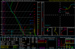
Sounding off latest GFS near the Itawamba/Monroe County line.
Man thats some skinny CAPESounding off latest GFS near the Itawamba/Monroe County line.
Man thats some skinny CAPE

Well IT IS the winter tornado season lol.Man thats some skinny CAPE
.png")
.png")
.png")
.png")

Last few runs of the GFS (above) and Euro (below) have the trough a good bit more funkified than the last day or two, with the parent low pressure saying sayonara and lifting up out of CONUS. Would probably emphasize more of a squall line situation, though the threat for QLCS tornadoes would definitely still be there (sounding attached from West Alabama)
View attachment 22294View attachment 22295
View attachment 22296View attachment 22297
View attachment 22299

")