
Navigation
Install the app
How to install the app on iOS
Follow along with the video below to see how to install our site as a web app on your home screen.
Note: This feature may not be available in some browsers.
More options
-
Welcome to TalkWeather! We see you lurking around TalkWeather! Take the extra step and join us today to view attachments, see less ads and maybe even join the discussion. CLICK TO JOIN TALKWEATHER
You are using an out of date browser. It may not display this or other websites correctly.
You should upgrade or use an alternative browser.
You should upgrade or use an alternative browser.
Severe Weather Threat 5/19-5/22/2024
- Thread starter Taylor Campbell
- Start date
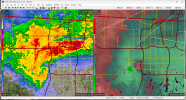
TOR now for OKC, Moore and Norman.
BULLETIN - EAS ACTIVATION REQUESTED
Tornado Warning
National Weather Service Norman OK
956 PM CDT Sun May 19 2024
The National Weather Service in Norman has issued a
* Tornado Warning for...
Southwestern Oklahoma County in central Oklahoma...
Northwestern Cleveland County in central Oklahoma...
Southeastern Canadian County in central Oklahoma...
Northwestern McClain County in central Oklahoma...
* Until 1045 PM CDT.
* At 955 PM CDT, a severe thunderstorm capable of producing a tornado
was located over southwestern Oklahoma City, or near Mustang,
moving east at 25 mph. This storm has a history of producing
tornadoes!
HAZARD...Tornado and golf ball size hail.
SOURCE...Radar indicated rotation.
IMPACT...Flying debris will be dangerous to those caught without
shelter. Mobile homes will be damaged or destroyed.
Damage to roofs, windows, and vehicles will occur. Tree
damage is likely.
* Locations impacted include...
Oklahoma City, western Norman, Moore, Midwest City, Del City,
Newcastle, Yukon, Bethany, Mustang, Warr Acres, Tuttle, Valley
Brook, Tinker Air Force Base, Forest Park, Woodlawn Park, Lake
Aluma, and Smith Village.
This includes the following highways...
Interstate 35 between mile markers 110 and 133.
Interstate 40 between mile markers 132 and 157.
Interstate 44 between mile markers 107 and 128.
Interstate 240 between mile markers 1 and 9.
PRECAUTIONARY/PREPAREDNESS ACTIONS...
TAKE COVER NOW! Move to a storm shelter, safe room or an interior
room on the lowest floor of a sturdy building. Avoid windows. If you
are outdoors, in a mobile home, or in a vehicle, move to the closest
substantial shelter and protect yourself from flying debris.
&&
LAT...LON 3519 9742 3530 9767 3534 9767 3532 9770
3532 9773 3537 9783 3555 9783 3553 9740
TIME...MOT...LOC 0255Z 285DEG 21KT 3542 9767
TORNADO...RADAR INDICATED
MAX HAIL SIZE...1.75 IN
TornadoFan
Member
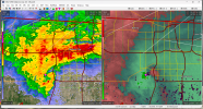
And it's moving SE towards Moore...
- Messages
- 751
- Reaction score
- 2,465
- Location
- Mississippi State University
- Special Affiliations
- SKYWARN® Volunteer
Very active day for a 5% TOR risk. I haven't been keeping up with it but came here when I saw a TOR warning for OKC metro/Moore.
CheeselandSkies
Member
Crazy supercell behavior. Each tornado occludes and zips off to the NNW while the overall storm propagates and cycles to the SE.
The FV3 was somehow right...Very active day for a 5% TOR risk. I haven't been keeping up with it but came here when I saw a TOR warning for OKC metro/Moore.

Tanner
Member
Actually more typical than you'd think. Surface lows commonly will occlude to the north and take a northwest turn at the very end of their life cycle.Crazy supercell behavior. Each tornado occludes and zips off to the NNW while the overall storm propagates and cycles to the SE.
TornadoFan
Member
Muwx
Member
It’s really trying right now.
jiharris0220
Member
Absolutely insane pictures coming out from today.

TornadoFan
Member
It's gonna be right over OKC airport..

jiharris0220
Member
Please, for all things holy, don’t produce.
Kds86z
Member
Bad ..Aye aye aye.
View attachment 27292

jmills
Member
Couplet has developed in the larger mesocyclone on the latest scan

TornadoFan
Member

CheeselandSkies
Member
- Messages
- 751
- Reaction score
- 2,465
- Location
- Mississippi State University
- Special Affiliations
- SKYWARN® Volunteer
TWC has been a joke for over a decade.Where is The Weather Channel when you need them?
It tried too hard to turn into an entertainment channel too but I think that drove off a lot of it's viewers (like me).
I remember once (cannot remember the day and year) where there were like 4 or 5 active warnings in April and they were too busy showing Highway Thru Hell or whatever that show is called.
I haven't watched TWC in probably 6 years.