
Navigation
Install the app
How to install the app on iOS
Follow along with the video below to see how to install our site as a web app on your home screen.
Note: This feature may not be available in some browsers.
More options
-
Welcome to TalkWeather! We see you lurking around TalkWeather! Take the extra step and join us today to view attachments, see less ads and maybe even join the discussion. CLICK TO JOIN TALKWEATHER
You are using an out of date browser. It may not display this or other websites correctly.
You should upgrade or use an alternative browser.
You should upgrade or use an alternative browser.
Severe Weather Threat 5/19-5/22/2024
- Thread starter Taylor Campbell
- Start date

TornadoFan
Member
Circulation is trying to tighten up.
SmokeEater
Member
TOG north of OCCC moving east per OUN.
Kolle
Member


- Messages
- 751
- Reaction score
- 2,465
- Location
- Mississippi State University
- Special Affiliations
- SKYWARN® Volunteer
What is the timetable for this event to end?
jiharris0220
Member
While wait for hopefully a nothing burger, here’s yet another photo of the earlier tornado.


- Thread starter
- Moderator
- #251
I wonder if Kerr at the SPC has figured out why the main hail core is over downtown and the tornado threat is in the south OKC metro. He thought this was coming to the north Oklahoma city metro.
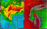
Tip- look at the velocity loop and you can tell the direction of the meso.
Tip- look at the velocity loop and you can tell the direction of the meso.
Last edited:
SVR issued now to replace the TOR.
BULLETIN - IMMEDIATE BROADCAST REQUESTED
Severe Thunderstorm Warning
National Weather Service Norman OK
1024 PM CDT Sun May 19 2024
The National Weather Service in Norman has issued a
* Severe Thunderstorm Warning for...
Southern Oklahoma County in central Oklahoma...
Northeastern Cleveland County in central Oklahoma...
* Until 1115 PM CDT.
* At 1023 PM CDT, a severe thunderstorm was located over Del City,
moving east at 30 mph.
HAZARD...70 mph wind gusts and ping pong ball size hail.
SOURCE...Radar indicated.
IMPACT...People and animals outdoors will be injured. Expect hail
damage to roofs, siding, windows, and vehicles. Expect
considerable tree damage. Wind damage is also likely to
mobile homes, roofs, and outbuildings.
* Locations impacted include...
Oklahoma City, northeastern Norman, Moore, Midwest City, Del City,
Choctaw, Harrah, Spencer, Jones, Nicoma Park, Valley Brook, Stella,
Tinker Air Force Base, Stanley Draper Lake, Newalla, northern Lake
Thunderbird, Forest Park, Lake Aluma, and Smith Village.
PRECAUTIONARY/PREPAREDNESS ACTIONS...
For your protection move to an interior room on the lowest floor of a
building.
&&
LAT...LON 3526 9714 3534 9757 3552 9758 3561 9714
TIME...MOT...LOC 0323Z 269DEG 27KT 3544 9743
THUNDERSTORM DAMAGE THREAT...CONSIDERABLE
HAIL THREAT...RADAR INDICATED
MAX HAIL SIZE...1.50 IN
WIND THREAT...RADAR INDICATED
MAX WIND GUST...70 MPH
Muwx
Member
Strong rotation on the northern Oklahoma cell now
TornadoFan
Member
Tight couplet near Waynoka.
Kds86z
Member
How long was the Yukon tornado down?
kcyalater
Member
seriously. that thing is wrapped up.Tight couplet near Waynoka.
- Messages
- 751
- Reaction score
- 2,465
- Location
- Mississippi State University
- Special Affiliations
- SKYWARN® Volunteer
Very tight couplet with some impressive winds
kcyalater
Member
odd presentation imo 

