Tomcats Forever!
Member
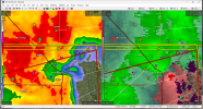
Maybe a problem for Thomas, Oklahoma, or is it not moving that way?
Follow along with the video below to see how to install our site as a web app on your home screen.
Note: This feature may not be available in some browsers.
Moving at 80mph???BULLETIN - EAS ACTIVATION REQUESTED
Severe Thunderstorm Warning
National Weather Service Wichita KS
801 PM CDT Sun May 19 2024
The National Weather Service in Wichita has issued a
* Severe Thunderstorm Warning for...
Chase County in east central Kansas...
Butler County in south central Kansas...
Southeastern Marion County in central Kansas...
* Until 845 PM CDT.
* At 800 PM CDT, severe thunderstorms were located along a line
extending from near Goessel to 5 miles southwest of Whitewater to
West Wichita, moving east at 80 mph.
HAZARD...90 mph wind gusts and half dollar size hail.
SOURCE...Radar indicated.
IMPACT...You are in a life-threatening situation. Flying debris
may be deadly to those caught without shelter. Mobile
homes will be heavily damaged or destroyed. Homes and
businesses will have substantial roof and window damage.
Expect extensive tree damage and power outages.
* Locations impacted include...
El Dorado, Andover, Augusta, Rose Hill, Marion, Douglass, Towanda,
Peabody, Benton, Whitewater, Leon, Florence, Potwin, Elbing, Burns,
Latham, Rosalia, Cassoday, Bazaar, and Matfield Green.
PRECAUTIONARY/PREPAREDNESS ACTIONS...
Remain alert for a possible tornado! Tornadoes can develop quickly
from severe thunderstorms. If you spot a tornado go at once into the
basement or small central room in a sturdy structure.
For your protection move to an interior room on the lowest floor of a
building.
&&
LAT...LON 3837 9715 3835 9635 3809 9636 3808 9652
3748 9653 3748 9715
TIME...MOT...LOC 0100Z 255DEG 69KT 3819 9731 3793 9724 3769 9749
TORNADO...POSSIBLE
THUNDERSTORM DAMAGE THREAT...DESTRUCTIVE
HAIL THREAT...RADAR INDICATED
MAX HAIL SIZE...1.25 IN
WIND THREAT...RADAR INDICATED
MAX WIND GUST...90 MPH
$$
LAWSON
Moving at 80mph???
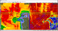
Large tor report 5 minutes ago with that.Very likely a huge nasty tornado on that now, very wrapped in rain, shame there isn't a closer radar
That CWA is a speed trap, the storm doesn’t want to get a ticketThat's what it says, although I've found the storm speeds given in NWS warning statements are not always accurate and can be quite confusing. Sometimes a storm will cross CWA boundaries and the warning issued by the next office will say it's moving 25 MPH faster or slower than the previous office!
Big question now is the incoming merger. If it’s constructive we’ve got a big problem.Very likely a huge nasty tornado on that now, very wrapped in rain, shame there isn't a closer radar