Kds86z
Member
Watch Oklahoma now I guess.. ️
Follow along with the video below to see how to install our site as a web app on your home screen.
Note: This feature may not be available in some browsers.
is that the cell that the models depicted?
Looks like it. We shall wait and see.is that the cell that the models depicted?
Every other model was showing that storm, albeit nowhere near what the FV3 showed. Who knows?If that ends up verifying after we spent so much time dunking on the FV3 I swear lol
Yep, definitely watching. Rather baffled at SPC's Day 3 outlook and the lack of a hatched area for any hazard, given the general pattern (compact, negatively tilted shortwave, deepening surface low with rich moisture in the warm sector) and environment depicted over parts of IA/MN/WI on the models.
...SUMMARY...
A broad area of severe thunderstorm potential is expected from the
southern Plains to the upper Great Lakes. The highest concentration
of severe storms is expected from eastern Kansas to southwest
Wisconsin. Damaging gusts, large hail and a few tornadoes are
possible through Monday night.

Nope, not enough boat chasers in that lake
When people ask why I quit chasing I show them images like this
Is there enough storm chasers on this storm lol?


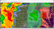
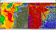
...A TORNADO WARNING REMAINS IN EFFECT UNTIL 815 PM CDT FOR
NORTHWESTERN CADDO...EASTERN CUSTER AND SOUTHWESTERN BLAINE
COUNTIES...
At 736 PM CDT, a confirmed large and extremely dangerous tornado was
located 5 miles west of Custer City, moving east at 30 mph.
This is a PARTICULARLY DANGEROUS SITUATION. TAKE COVER NOW!
HAZARD...Damaging tornado.
SOURCE...Broadcast media confirmed tornado.