• Welcome to TalkWeather!
    We see you lurking around TalkWeather! Take the extra step and join us today to view attachments, see less ads and maybe even join the discussion.
    CLICK TO JOIN TALKWEATHER
  • April 2024 Weather Video of the Month
    Post your nominations now!

Severe Weather Threat 5/19-5/22/2024

JBishopwx

Member
Sustaining Member
Messages
981
Reaction score
2,274
Location
Ackerman, MS
Special Affiliations
  1. SKYWARN® Volunteer
First PDS Severe Thunderstorm Watch in Kansas since 08-12-2019
 
Last edited:

wx_guy

Member
Messages
336
Reaction score
962
Location
United States
HAM Callsign
KO4ZGH
Special Affiliations
  1. SKYWARN® Volunteer
  2. ARRL Member
Central Kansas at 0Z tonight from the latest HRRR sounding...it SCREAMS damaging winds and large hail, in my opinion. Tornado conditions aren't that bad either, but the damaging wind parameter is high, DCAPE is over 1500, TEI over 30, SHIP going on 3, high lapse rates all through, high CAPE at all levels, and with Lifted Indices over 10 you can likely expect very strong updrafts. Yeah, I think the PDS is totally warranted.

1716149779758.png
 

JBishopwx

Member
Sustaining Member
Messages
981
Reaction score
2,274
Location
Ackerman, MS
Special Affiliations
  1. SKYWARN® Volunteer
Is that for Kansas area? The last PDS Severe Thunderstorm Watch nationally was June 14th, 2023
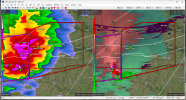
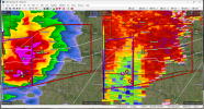
Yep, just edited it.
 

brianc33710

Member
Messages
383
Reaction score
276
Location
Central Alabama
Special Affiliations
  1. SKYWARN® Volunteer
Isolated tornadoes mentioned in pds svr watch? I’ve tracked weather for 20 years, but seems odd?

That's not exactly a common occurrence... 95/90 wind, 95/80 hail.
When the SPC upgraded to MOD Risk earlier today, Tornado was only 5% but Wind & Hail were hatched & 45%, with 75-100 mph mentioned. So the rare PDS Severe Thunderstorm Watch is the right choice here. After Houston last week I know SPC probably wants to get better ahead of potentially damaging straight line winds/ derecho events.
 
Messages
3,041
Reaction score
5,293
Location
Madison, WI
809
WUUS53 KDDC 192249
SVRDDC
KSC047-057-083-097-145-151-185-192345-
/O.NEW.KDDC.SV.W.0066.240519T2249Z-240519T2345Z/

BULLETIN - EAS ACTIVATION REQUESTED
Severe Thunderstorm Warning
National Weather Service Dodge City KS
549 PM CDT Sun May 19 2024

The National Weather Service in Dodge City has issued a

* Severe Thunderstorm Warning for...
Eastern Ford County in southwestern Kansas...
Kiowa County in south central Kansas...
Southeastern Hodgeman County in southwestern Kansas...
Southeastern Pawnee County in south central Kansas...
Stafford County in south central Kansas...
Pratt County in south central Kansas...
Edwards County in south central Kansas...

* Until 645 PM CDT.

* At 548 PM CDT, severe thunderstorms were located along a line
extending from near Offerle to 8 miles southwest of Centerview to
near Bucklin, moving east at 65 mph.

THESE ARE DESTRUCTIVE STORMS FOR ALL TOWNS ALONG US-50 AND US-400
EAST OF BUCKLIN AND SPEARVILLE.


HAZARD...80 mph wind gusts and quarter size hail.

SOURCE...Radar indicated.

IMPACT...Flying debris will be dangerous to those caught without
shelter. Mobile homes will be heavily damaged. Expect
considerable damage to roofs, windows, and vehicles.
Extensive tree damage and power outages are likely.

* Severe thunderstorms will be near...
Kinsley, Greensburg, Mullinville, Fellsburg, and Centerview around
555 PM CDT.
Lewis and Trousdale around 600 PM CDT.
Garfield, Belpre, and Hopewell around 605 PM CDT.

Other locations in the path of these severe thunderstorms include
Haviland, Macksville, Zook, Byers, Dillwyn, Wellsford, Pratt,
Cullison, St. John, Iuka, Stafford, Preston, Hudson and Neola.

PRECAUTIONARY/PREPAREDNESS ACTIONS...

For your protection move to an interior room on the lowest floor of a
building.

&&

LAT...LON 3747 9865 3747 9982 3770 9977 3799 9997
3817 9857 3790 9847 3784 9847
TIME...MOT...LOC 2248Z 259DEG 57KT 3796 9962 3775 9941 3752 9962

THUNDERSTORM DAMAGE THREAT...DESTRUCTIVE
HAIL THREAT...RADAR INDICATED
MAX HAIL SIZE...1.00 IN
WIND THREAT...RADAR INDICATED
MAX WIND GUST...80 MPH

$$

SPRINGER
 

brianc33710

Member
Messages
383
Reaction score
276
Location
Central Alabama
Special Affiliations
  1. SKYWARN® Volunteer
I assume some of these storms will meet both "destructive" criteria today, 80 mph winds & 2.75" hail, given the KS atmosphere conditions today. I remember when @Fred Gossage explained how dewpoint depressions are better for severe thunderstorms awhile back. That's why YT Convective Chronicles said KS would get massive svr tstms today instead of tornadoes. The temp/dp spreads are large but other factors are very strong today.

@CheeselandSkies now there's a warning for 90 mph. Let me get on my laptop.
 
Last edited:
Messages
3,041
Reaction score
5,293
Location
Madison, WI
I assume some of these storms will meet both "destructive" criteria today, 80 mph winds & 2.75" hail, given the KS atmosphere conditions today. I remember when @Fred Gossage explained how dewpoint depressions are better for severe thunderstorms awhile back. That's why YT Convective Chronicles said KS would get massive svr tstms today instead of tornadoes. The temp/dp spreads are large but other factors are very strong today.

@CheeselandSkies now there's a warning for 90 mph. Let me get on my laptop.


945
WWUS53 KDDC 192310
SVSDDC

Severe Weather Statement
National Weather Service Dodge City KS
610 PM CDT Sun May 19 2024

KSC047-057-083-097-145-151-185-192345-
/O.CON.KDDC.SV.W.0066.000000T0000Z-240519T2345Z/
Ford KS-Kiowa KS-Hodgeman KS-Pawnee KS-Stafford KS-Pratt KS-
Edwards KS-
610 PM CDT Sun May 19 2024

...A SEVERE THUNDERSTORM WARNING REMAINS IN EFFECT UNTIL 645 PM CDT
FOR EASTERN FORD...KIOWA...SOUTHEASTERN HODGEMAN...SOUTHEASTERN
PAWNEE...STAFFORD...PRATT AND EDWARDS COUNTIES...

At 609 PM CDT, severe thunderstorms were located along a line
extending from near Garfield to near Hopewell to near Greensburg,
moving east at 65 mph.

THESE ARE DESTRUCTIVE STORMS FOR ALL TOWNS ALONG US-50 AND US-400
EAST OF MULLINVILLE AND OFFERLE.


HAZARD...90 mph wind gusts and half dollar size hail.

SOURCE...Radar indicated.

IMPACT...You are in a life-threatening situation. Flying debris may
be deadly to those caught without shelter. Mobile homes
will be heavily damaged or destroyed. Homes and businesses
will have substantial roof and window damage. Expect
extensive tree damage and power outages.

Locations impacted include...
Haviland, Macksville, Belpre, Byers, Hopewell, Zook, Wellsford,
Cullison, Dillwyn, Pratt, St. John, Iuka, Stafford, Neola, Preston
and Hudson.

PRECAUTIONARY/PREPAREDNESS ACTIONS...

For your protection move to an interior room on the lowest floor of a
building.

&&

LAT...LON 3747 9865 3747 9982 3772 9970 3802 9972
3817 9857 3790 9847 3784 9847
TIME...MOT...LOC 2309Z 259DEG 57KT 3802 9923 3781 9902 3758 9923

THUNDERSTORM DAMAGE THREAT...DESTRUCTIVE
HAIL THREAT...RADAR INDICATED
MAX HAIL SIZE...1.25 IN
WIND THREAT...RADAR INDICATED
MAX WIND GUST...90 MPH
 
Back
Top