
Navigation
Install the app
How to install the app on iOS
Follow along with the video below to see how to install our site as a web app on your home screen.
Note: This feature may not be available in some browsers.
More options
-
Welcome to TalkWeather! We see you lurking around TalkWeather! Take the extra step and join us today to view attachments, see less ads and maybe even join the discussion. CLICK TO JOIN TALKWEATHER
You are using an out of date browser. It may not display this or other websites correctly.
You should upgrade or use an alternative browser.
You should upgrade or use an alternative browser.
warneagle
Member
Yeah I’d be surprised if that one weren’t at least high end EF3There was a bit of one (not as dramatic as Mayfield) for a couple of scans with the violent tornado in the northwest Omaha metro today, but it was somewhat masked by a convective cell just south of the tornado getting ready to merge into the updraft. At around the time that was happening, reflectivity in the debris ball was around 70+ dbz and delta-v was 230+ mph, all 500-750 ft above ground level.
SilentShadow87
Member
Jeez, that's absolutely insane...TBSS on this storm… and I’m not sure it’s from hail.
SmokeEater
Member
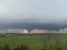
Big tor just east of Creston, IA.
WhirlingWx
Member
WhirlingWx
Member
SilentShadow87
Member
TornadoFan
Member
warneagle
Member
Looks significant but it’s so far from the radar that it’s hard to tell muchThe southern storm near grand river had significant rotation.
TornadoFan
Member
The models were pretty spot on for today.
Muwx
Member
The winterset storm really looks like it’s gonna try as it heads for Des Moines
warneagle
Member
Might be outrunning the best thermos but the kinematics ahead of these storms are very impressive still.
Velocities have really started coming down in intensity other than the brief cell mergers
Tempestas Tonitrua
Member
Might be outrunning the best thermos but the kinematics ahead of these storms are very impressive still.
There was a good case study video Trey did on the 3/2/2012 outbreak and noted how the West Liberty tornado moved outside the warm sector that was in KY into a more hostile thermodynamically environment in West Virginia. The storm was able to maintain a while longer based on the insane shear parameters but once a supercell is built up and mature it’s hard for it to stop and can take time to weaken in circumstances.
lake.effect
Member
Velocities are increasing on cell in SW Des Moines metro
edit = now warned
edit = now warned
warneagle
Member
True but we’re getting into a messier storm mode so that might mitigate their ability to continue to propagate. Translate? I can never keep those straight.There was a good case study video Trey did on the 3/2/2012 outbreak and noted how the West Liberty tornado moved outside the warm sector that was in KY into a more hostile thermodynamically environment in West Virginia. The storm was able to maintain a while longer based on the insane shear parameters but once a supercell is built up and mature it’s hard for it to stop and can take time to weaken in circumstances.
TornadoFan
Member
TDS SW of Des Moines.