BULLETIN - EAS ACTIVATION REQUESTED
Tornado Warning
National Weather Service Jackson MS
1026 AM CDT Sat Mar 15 2025
The National Weather Service in Jackson has issued a
* Tornado Warning for...
Southeastern Sunflower County in northwestern Mississippi...
Southwestern Leflore County in north central Mississippi...
Southeastern Washington County in northwestern Mississippi...
Humphreys County in central Mississippi...
Northeastern Sharkey County in west central Mississippi...
* Until 1130 AM CDT.
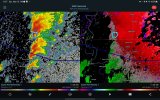
* At 1026 AM CDT, a large and extremely dangerous tornado was located
near Grace, or near Mayersville, moving northeast at 45 mph.
This is a PARTICULARLY DANGEROUS SITUATION. TAKE COVER NOW!
HAZARD...Damaging tornado.
SOURCE...Radar indicated rotation.
IMPACT...You are in a life-threatening situation. Flying debris
may be deadly to those caught without shelter. Mobile
homes will be destroyed. Considerable damage to homes,
businesses, and vehicles is likely and complete
destruction is possible.
* The tornado will be near...
Anguilla, Panther Burn, and Nitta Yuma around 1030 AM CDT.
Delta City around 1035 AM CDT.
Hollandale around 1040 AM CDT.
Murphy around 1045 AM CDT.
Belzoni and Isola around 1100 AM CDT.
Swiftown around 1110 AM CDT.
PRECAUTIONARY/PREPAREDNESS ACTIONS...
To repeat, a large, extremely dangerous and potentially deadly
tornado is on the ground. To protect your life, TAKE COVER NOW! Move
to a basement or an interior room on the lowest floor of a sturdy
building. Avoid windows. If you are outdoors, in a mobile home, or in
a vehicle, move to the closest substantial shelter and protect
yourself from flying debris.
Heavy rainfall may hide this tornado. Do not wait to see or hear the
tornado. TAKE COVER NOW!
&&
LAT...LON 3339 9031 3337 9031 3337 9032 3336 9031
3332 9031 3330 9033 3315 9033 3312 9043
3296 9083 3312 9097 3341 9052
TIME...MOT...LOC 1526Z 235DEG 38KT 3296 9100
TORNADO...RADAR INDICATED
TORNADO DAMAGE THREAT...CONSIDERABLE
MAX HAIL SIZE...1.75 IN
$$
SAS