KevinH
Member
That’s fair LOL..You can tell who has and who hasn’t.
I haven’t but I wouldn’t wish for “action”…. 3-03-2019 was enough
Follow along with the video below to see how to install our site as a web app on your home screen.
Note: This feature may not be available in some browsers.
That’s fair LOL..You can tell who has and who hasn’t.
There was - a belt of convection, which itself produced some tornadoes, moved across the northern third of Alabama into the early afternoon hours. This situation will be quite different compared to 4/27 - it's anything but a direct comparison, but at the most basic level, yes.You saying this reminds me of what I think happened on 4-27-2011. Wasn’t there a “morning round” that day too?
Yes there was a morning round. You have flashbacks due to the severity of that specific event.You saying this reminds me of what I think happened on 4-27-2011. Wasn’t there a “morning round” that day too?
I remember Spann saying “watch what happens in the MORNING”. Why am I having all of these flashbacks about these videos for an event I wasn’t even here for (I moved to GA in late 2011).
Sigh
I agree with this assessment. Nothing like 4/27 but it does have some small details in common like that morning round. All that would do is enhance the afternoon action.There was - a belt of convection, which itself produced some tornadoes, moved across the northern third of Alabama into the early afternoon hours. This situation will be quite different compared to 4/27 - it's anything but a direct comparison, but at the most basic level, yes.
Ok I thought so….There was - a belt of convection, which itself produced some tornadoes, moved across the northern third of Alabama into the early afternoon hours. This situation will be quite different compared to 4/27 - it's anything but a direct comparison, but at the most basic level, yes.
That enhancement is what I seem to remember Spann talking about. I thought Spann was saying something similar about THAT day.I agree with this assessment. Nothing like 4/27 but it does have some small details in common like that morning round. All that would do is enhance the afternoon action.
He did. I personally expect several tornadoes if we get the development of that second low pressure. From what I am currently seeing on the models this situation really reminds me of April 1998. So basically I wouldn’t be surprised to see one or two supercells really take off and drop something big.That enhancement is what I seem to remember Spann talking about. I thought Spann was saying something similar about THAT day.
When I looked at CIPS analogs earlier, the top one was 4/17/98 00z. But sneakily in there was 3/27/94 12z and additional tornado producing days in N/C GA. Always entertaining to look at regardless.He did. I personally expect several tornadoes if we get the development of that second low pressure. From what I am currently seeing on the models this situation really reminds me of April 1998. So basically I wouldn’t be surprised to see one or two supercells really take off and drop something big.
Umm wow
No thanks.
That 3/27/94 outbreak spawned the F4 that completely destroyed the neighborhood that I now reside in.When I looked at CIPS analogs earlier, the top one was 4/17/98 00z. But sneakily in there was 3/27/94 12z and additional tornado producing days in N/C GA. Always entertaining to look at regardless.
Which parts of MS/AL?00z GFS is trouble, big trouble on Saturday for MS/AL.
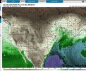
Large warm sector with plenty of instability and shear overlapping, a relatively diffuse wave to encourage discrete convection, and the subtropical jet remains off the coast which reduces its influence.
Most of MS/AL.Which parts of MS/AL?
Do you think TN is in play or just MS/AL?Most of MS/AL.