
I think it's most likely to stay south of TN for now, but we'll see how it evolves later.Most of MS/AL.
Navigation
Install the app
How to install the app on iOS
Follow along with the video below to see how to install our site as a web app on your home screen.
Note: This feature may not be available in some browsers.
More options
-
Welcome to TalkWeather! We see you lurking around TalkWeather! Take the extra step and join us today to view attachments, see less ads and maybe even join the discussion. CLICK TO JOIN TALKWEATHER
You are using an out of date browser. It may not display this or other websites correctly.
You should upgrade or use an alternative browser.
You should upgrade or use an alternative browser.
Severe WX Severe Weather Threat 3/14-3/16
- Thread starter Bulkshear
- Start date

CheeselandSkies
Member
How much shear? All of it.

MS/AL border.
MS/AL border.
I don't know enough to make any sort of predictions, but the steady and consistent increases in CAPE on all of these soundings seems extremely concerning. 3350 MUCAPE is insane. The April 26/27 2024 Great Plains outbreak that produced the Elkhorn EF4, Marietta EF4, Sulphur OK EF3 , and Minden/Harlan EF3 was only about 2500 KJ, and the system that produced the Greenfield tornado was in the 2500-3500 range. If we keep trending up towards 4000 we'll be getting up there with some of the all time most powerful storms.
- Thread starter
- #565
Bulkshear
Member

KevinH
Member
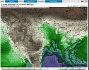
I forgot about CWASP! Do you have the few frames after this? I am wondering how the contours progress across AL and GA.That's an unsettling look for the Deep South into the Tennessee Valley.
View attachment 34972
KevinH
Member
And the south CAN do more with less cape… other factors considering.I don't know enough to make any sort of predictions, but the steady and consistent increases in CAPE on all of these soundings seems extremely concerning. 3350 MUCAPE is insane. The April 26/27 2024 Great Plains outbreak that produced the Elkhorn EF4, Marietta EF4, Sulphur OK EF3 , and Minden/Harlan EF3 was only about 2500 KJ, and the system that produced the Greenfield tornado was in the 2500-3500 range. If we keep trending up towards 4000 we'll be getting up there with some of the all time most powerful storms.


- Thread starter
- #569
Bulkshear
Member
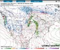
I wouldn’t expect the numbers to change much in regards to risk. The storm should consolidate into a line by then so if you have issues it will probably come from a QLCS. Granted you can still get powerful tornadoes in a QLCS but its better to have that rather than a swarm of supercells..I forgot about CWASP! Do you have the few frames after this? I am wondering how the contours progress across AL and GA.
KevinH
Member
That’s what always seems to happen in W C GA… QLCSI wouldn’t expect the numbers to change much in regards to risk. The storm should consolidate into a line by then so if you have issues it will probably come from a QLCS. Granted you can still get powerful tornadoes in a QLCS but its better to have that rather than a swarm of supercells..
Its like the SCs see the GA border and decide to change from discrete to QLCS.
KevinH
Member
I like this. Would be interesting to see this with the EURO model. Especially if Spann favors it over the GFS.Well I just wanted to see what ChatGPT had to say for fun. Enjoy!
- Thread starter
- #572
Bulkshear
Member
I am about to do it hahaI like this. Would be interesting to see this with the EURO model. Especially if Spann favors it over the GFS.
- Thread starter
- #573
Bulkshear
Member
- Thread starter
- #574
Bulkshear
Member
- Thread starter
- #575
Bulkshear
Member
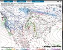
So no secondary low on this Euro run. Lots of what it appears to be super cellular action going on.
KCweatherboy
Member
I think the moisture on the Euro shows we're fully in the model flip-flop time

KevinH
Member
What does everyone this the best D4-8 is going to say about Frida/Sat!’
- Thread starter
- #578
Bulkshear
Member
Wouldn't higher CAPE, by its very nature, prevent the formation of a squall line? Can the atmosphere really form something linear in so much instability? Got a little curious, and did some digging. This study says the average Springtime QLCS forms in 500-2000 CAPE. 3500 J/kg would blow that out of the water (literally).
I also want to re-highlight A comment I posted in the Severe Weather Megathread, because it feels especially relevant now.
I think people (and models) could be underestimating the type of highly atypical and powerful ingredients we're sending from up here in the north to the Dixie Alley.
I also want to re-highlight A comment I posted in the Severe Weather Megathread, because it feels especially relevant now.
Anecdotally, Iowa has had record low snowfall totals this winter. The last time snow totals were this low was the 1965-66 winter. The '66 tornado season opened with the March 3rd Candlestick Park, MS F5 which killed 58 and injured 521. There were 3 total F5s that season.
Tornadoes of 1966
I've been thinking all winter it seems abnormal how far south these huge cold fronts have been pushing. Iowa hasn't been getting snow because everything is developing way further south than normal. With record high temps in the gulf and several winter storms in Dixie alley this year, it seems like a recipe for big outbursts of severe weather in the south as seasons change.
I think people (and models) could be underestimating the type of highly atypical and powerful ingredients we're sending from up here in the north to the Dixie Alley.
Last edited:
The 04/27/2011 outbreak occured in a 2000-3000 CAPE environment. It was 3000-4000 J/kg on the 26th, but the system that moved in that night cleared some of it out. It seems like all the other factors are at alarming levels. Not 2011 levels by any means, but certainly trending towards something incredible.And the south CAN do more with less cape… other factors considering.