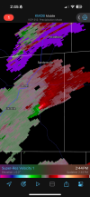
Yep. Was just noticing that. Would track across the southern part of Mobile if it maintains itself.Pretty sure there is a CC drop on the new TOR for Tillmans Corner.
Navigation
Install the app
How to install the app on iOS
Follow along with the video below to see how to install our site as a web app on your home screen.
Note: This feature may not be available in some browsers.
More options
-
Welcome to TalkWeather! We see you lurking around TalkWeather! Take the extra step and join us today to view attachments, see less ads and maybe even join the discussion. CLICK TO JOIN TALKWEATHER
You are using an out of date browser. It may not display this or other websites correctly.
You should upgrade or use an alternative browser.
You should upgrade or use an alternative browser.
Severe Weather Threat 12.26-12.29.2024
- Thread starter JBishopwx
- Start date
- Thread starter
- #262
TDS on radar just southeast of Dees, Al
MMWX
Member
- Messages
- 751
- Reaction score
- 2,465
- Location
- Mississippi State University
- Special Affiliations
- SKYWARN® Volunteer
cheestaysfly
Member
Here's to hoping it stays relatively quiet up here in North West Alabama!
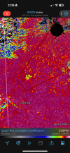
Still really good structure on that tornado. Looks weaker on velocity I guess because of proximity to radar. Deeper cc drop currently
AJS
Member
Smithville just can’t seem to catch a break!Look whose house is right in the zone of the updraft helicity. Yours truly
cincywx
Member

AJS
Member

MMWX
Member
- Messages
- 751
- Reaction score
- 2,465
- Location
- Mississippi State University
- Special Affiliations
- SKYWARN® Volunteer
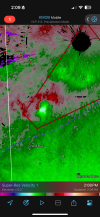
Gonna be hard to see it on radar if it stays on the ground for the next couple of minutes. Heading right for the KMOB radar. Does look to be weakening, though.
- Thread starter
- #270
NWS Mobile on the edge of taking cover.
I've noticed this on the HRRR and NAM/3km NAM. Is there any particular reason as to why the SCP/STP don't match up to where the storms are? I have noticed that trend over the past few years and just assumed it's because of lack of CAPE further northward. However, I'm beginning to wonder if there's another reason. Question is for someone more fluent in forecast models than I am.
Dunno, but have noticed this also. There are times when it does verify but it often doesn't. My only guess is somehow the models are not synchronizing convection and convective parameters.I've noticed this on the HRRR and NAM/3km NAM. Is there any particular reason as to why the SCP/STP don't match up to where the storms are? I have noticed that trend over the past few years and just assumed it's because of lack of CAPE further northward. However, I'm beginning to wonder if there's another reason. Question is for someone more fluent in forecast models than I am.
- Moderator
- #273
Sure are a lot of cells popping up in south MS...


Cell north of Hattiesburg has some rotation on itSure are a lot of cells popping up in south MS...
- Moderator
- #276
Cell north of Hattiesburg has some rotation on it
I do hope we're not about to get several surprises.
MMWX
Member
- Messages
- 751
- Reaction score
- 2,465
- Location
- Mississippi State University
- Special Affiliations
- SKYWARN® Volunteer
Two areas of interest for me currently. Both have rotation.
Cell just NW of Petal, and cell east of Ellisville. East of Ellisville needs a warning.
Cell just NW of Petal, and cell east of Ellisville. East of Ellisville needs a warning.
Tanner
Member
I really don’t love seeing a debris ball and associated tornado near Mobile. I hope people are aware that more might be coming.
MMWX
Member
- Messages
- 751
- Reaction score
- 2,465
- Location
- Mississippi State University
- Special Affiliations
- SKYWARN® Volunteer