
Navigation
Install the app
How to install the app on iOS
Follow along with the video below to see how to install our site as a web app on your home screen.
Note: This feature may not be available in some browsers.
More options
-
Welcome to TalkWeather! We see you lurking around TalkWeather! Take the extra step and join us today to view attachments, see less ads and maybe even join the discussion. CLICK TO JOIN TALKWEATHER
You are using an out of date browser. It may not display this or other websites correctly.
You should upgrade or use an alternative browser.
You should upgrade or use an alternative browser.
Severe Weather Threat 1/5-1/6/2025
- Thread starter ashtonlemleywx
- Start date
I do expect that both the Enhanced Risk as well as 10% tornado probability gets expanded eastward to Meridian up to Tupelo.
Ledian
Member
Welp...i'll have flashlights, pillows and blankets on stand by just in case.
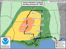
Dang that 10% came sooner than I thought! Haha I thought it would be issued day of the event. I'm wondering if a hatched area will be introduced, I wouldn't place my bets on it currently as of now.New Day 2 Outlook:
Slight Risk expanded eastward to Meridian and up to Tupelo
Enhanced Risk remains same mostly with slight expansion back west and somewhat east. 10% non hatch tornado risk introduced.
warneagle
Member
I think it's kind of funny that they say "severe wind gusts, tornadoes, and hail will be the primary threats" when that's like...all of the threats there are.
Yeah, not picking up an earthquake threat with this systemI think it's kind of funny that they say "severe wind gusts, tornadoes, and hail will be the primary threats" when that's like...all of the threats there are.
12Z HRRR depicts some semi-discrete convection ahead of the prefrontal QLCS, and suggests that the tornado threat will likely maximize somewhere along the AR/LA/MS borders in the evening. NAM 3km depicts highest threat over parts of LA and has a somewhat more impressive kinematic environment (soundings from Rolling Fork vicinity and NE LA, respectively). Lean towards HRRR solution; in any case, QLCS tornado threat and serious damaging winds from squall line activity. NAM UH shows fairly light swaths, but as has been discussed before, it tends to underdo it.


AJS
Member
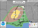
Looks like they went with a 10% tornado risk. Wondering if they’ll go hatched in the next outlook.
cg9450
Member
Don’t jinx it, the New Madrid line been quiet since the river flowed backwards that once timeYeah, not picking up an earthquake threat with this system
It'll be a dangerous day tommorow if you can get a few supercells rooted and going tommorow, looks like based on the HRRR that you'll have about 6 hour or so before the line catches up. Real time observations and whether the winds get a little more backed in the low levels tommorow will go a long way. I think im expecting a hatched area by day 1; just looking through things for tommorow but it's more conditional than the last severe threat we had. We will have to see how the day starts out/ plays out tommorow morning. I'm excited, it's been forever since we've had any palpable severe weather threats in the south and we've gotten two close together! Tommorow can definitely be a dangerous tornado day but it's very conditional!!
*Both the WRF and HRRR show lots of low top kidney beans ahead of the front so that makes me a little nervous haha. If they can get going we will be in trouble
*Both the WRF and HRRR show lots of low top kidney beans ahead of the front so that makes me a little nervous haha. If they can get going we will be in trouble
Last edited:
KevinH
Member
It’s overdueDon’t jinx it, the New Madrid line been quiet since the river flowed backwards that once time
Yep! I'll be ready got my nieces birthday at noon. And then I'm racing home to watch.
The early morning runs on the HRRR were more impressive than the current one, but the current one still hints at two broken rows of potential supercells. Will just have to watch how they day evolves. .png")
.png")
BOOM! 
AJS
Member
Had a feeling it would be hatched.
- Moderator
- #76
I’m concerned about the HRRR’s consistency with the lead supercells. Also poor Rolling Fork could be a prime target.
AJS
Member
Yeah… Rolling Fork is right in the 10% hatched.I’m concerned about the HRRR’s consistency with the lead supercells. Also poor Rolling Fork could be a prime target.
Sun is shining bright here in Smithville currently. Much earlier than on December 28th
Ledian
Member
Sunshine is coming and going here in Pontotoc