
Navigation
Install the app
How to install the app on iOS
Follow along with the video below to see how to install our site as a web app on your home screen.
Note: This feature may not be available in some browsers.
More options
-
Welcome to TalkWeather! We see you lurking around TalkWeather! Take the extra step and join us today to view attachments, see less ads and maybe even join the discussion. CLICK TO JOIN TALKWEATHER
You are using an out of date browser. It may not display this or other websites correctly.
You should upgrade or use an alternative browser.
You should upgrade or use an alternative browser.
Severe Weather Thread - 7/18 - 7/21/2026
- Thread starter WeathermanLeprechaun
- Start date

15z Nam NST verified almost exactly. Now lets see if the 18z verifies with another big chonker over central Wisconsin popping up soon.
- Thread starter
- #104

WeathermanLeprechaun
Member
Turns out the low level stability I mentioned earlier verified in SW WI. Environment us capped up there
It's obviously the one area that will not have anything happening today.Turns out the low level stability I mentioned earlier verified in SW WI. Environment us capped up there
Beachwalker
Member
That warned storm in Iowa looks like it threw out a powerful outflow boundary about 30 mins ago.
- Thread starter
- #107
WeathermanLeprechaun
Member
Today could've gone decently big considering how orthogonal flow worked out in Wisconsin. But the area with a decently solid LLJ I've mentioned a bunch got stabilised a lot, and so we're looking at the UP for our best tornado threat.
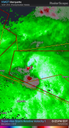
And sigtor may be coming in shore east of Marquette, vortex hole too!
And sigtor may be coming in shore east of Marquette, vortex hole too!
DanLarsen34
Member
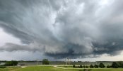
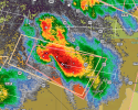
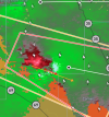
My in-laws captured these images over Jewell Junction!
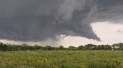
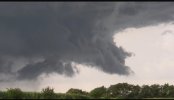
gnarly storm over NE Wisconsin
DanLarsen34
Member
I think we may have got lucky with that area that jets out into the lake. The circulation weakened just before coming onshore since there’s a new circulation forming off to the SE that’s likely choked the original storm off. There a decent amount of homes in this area, so if there is a tornado, it hit homes.
Attachments
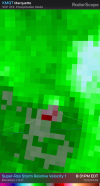
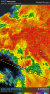
This is actually over the UP of Michigan not Wisconsin.

jiharris0220
Member
The supercell tornado threat is commencing in Michigan and northern Wisconsin, but as expected the supercells are being disrupted by mid level dry air and unfavorable storm motion vectors, but it seems we already had a couple tornadoes so far there, and could very well be a couple more if they bunker more right. As of now though, the 35knot LLJ is being rendered useless because the storms are moving too fast in its same general direction.
Can really see where the cold pool plus anvil shading from the new MCS is causing convective inhibition for the main area of concern today. The hrrr really whiffed this one, it completely missed the development of an entirely new MCS system.
It formed before the convection that was expected to initiate at 5-6pm could even do so, so a bust scenario in that area.
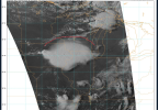
Can really see where the cold pool plus anvil shading from the new MCS is causing convective inhibition for the main area of concern today. The hrrr really whiffed this one, it completely missed the development of an entirely new MCS system.
It formed before the convection that was expected to initiate at 5-6pm could even do so, so a bust scenario in that area.
Last edited:
jiharris0220
Member
To make things clear, when I say “unfavorable storm motion vectors” I’m talking about this specific circumstance here.
As you can see, the 850mb LLJ is around 35knots, coming from west to east, the sounding taken in the general vicinity, shows a storm motion velocity for right movers of around 30knots. Because these supercells are also moving in the same general direction as the LLJ and at the same general velocity, they are hardly feeling any shear in the low levels at all.
That’s why they need to deviate straight towards the southeast so that they can actually feel the LLJ, which is what the souther most cell is trying to achieve.
Mid level dry air is putting a stop to the storms trying to mature in central Wisconsin, and the unexpected MCS towards the south put an end to the tornado threat there.
These factors, which were talked about earlier today are the reasons why for the most part, this event has underperformed.
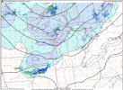
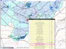
As you can see, the 850mb LLJ is around 35knots, coming from west to east, the sounding taken in the general vicinity, shows a storm motion velocity for right movers of around 30knots. Because these supercells are also moving in the same general direction as the LLJ and at the same general velocity, they are hardly feeling any shear in the low levels at all.
That’s why they need to deviate straight towards the southeast so that they can actually feel the LLJ, which is what the souther most cell is trying to achieve.
Mid level dry air is putting a stop to the storms trying to mature in central Wisconsin, and the unexpected MCS towards the south put an end to the tornado threat there.
These factors, which were talked about earlier today are the reasons why for the most part, this event has underperformed.

CheeselandSkies
Member
Just got back from driving in a big circle from Madison-Prairie du Chien-Elgin, IA-Strawberry Point-Manchester-Dubuque-Madison. Saw nothing but rain and a few lightning bolts, didn't even stop to intercept or take any pictures/video. Huge bust in what was expected to be the prime target area. Seems the only storm that did anything was the one way on the western end by Webster City (west of I-35, way further than I ever planned on going today) and judging by the lack of pictures posted on here (other than the ones by @Grand Poo Bah after any tornado had dissipated) even that may not have been much.
Last edited:
Storm just passed over Des Moines and that was one of the cooler things I've seen. For being an MCS it was incredibly turbulent with rotation and SLCs all over the place.
Beachwalker
Member
Well, here we go in WI. Looking discrete for a little while at least. Couple warnings right away.
CheeselandSkies
Member
lol:
Storm Prediction Center Mesoscale Discussion 1681
Severe weather, tornado, thunderstorm, fire weather, storm report, tornado watch, severe thunderstorm watch, mesoscale discussion, convective outlook products from the Storm Prediction Center.
www.spc.noaa.gov
CheeselandSkies
Member
Even the 21Z RRFS-A (initialized after the IA MCS was well in progress) has supercells in SE MN, NE IA and SW WI in the 00-03Z timeframe that are obviously not going to happen.
CheeselandSkies
Member
Not sure what is up with all these tornado warnings on these teensy a** storms that barely have a reflectivity signature let alone velocity. To be fair, central Wisconsin is a pretty terrible radar hole, but KGRB is hitting the storms southeast of Antigo and near Weston at about 4-6K' up (not ridiculous) and...yeah.
Edit: This is radar confirmed?! OK...
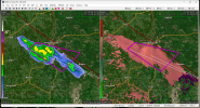
Edit: This is radar confirmed?! OK...