
Navigation
Install the app
How to install the app on iOS
Follow along with the video below to see how to install our site as a web app on your home screen.
Note: This feature may not be available in some browsers.
More options
-
Welcome to TalkWeather! We see you lurking around TalkWeather! Take the extra step and join us today to view attachments, see less ads and maybe even join the discussion. CLICK TO JOIN TALKWEATHER
You are using an out of date browser. It may not display this or other websites correctly.
You should upgrade or use an alternative browser.
You should upgrade or use an alternative browser.
Severe Weather 3/9 - 3/12
- Thread starter CheeselandSkies
- Start date
Cyclonic Paracosm
Member

SCWX updated and with it a seperate snapshot also updated being derived products so srv and a derived ver of kdp is back, (what is kdp use for I've not much clue abt it or its use cases)

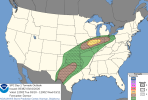
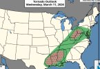
Surprisingly few changes to the tornado risk, but here's a few I notice:
- More CIG1 connecting Illinois and Texas.
- Some 5% and 2% hatched in northern Ohio, almost all the way to Columbus. In the previous map Ohio only had a small area of 2% hatched.
- More CIG1 connecting Illinois and Texas.
- Some 5% and 2% hatched in northern Ohio, almost all the way to Columbus. In the previous map Ohio only had a small area of 2% hatched.
Attachments
Kds86z
Member
Nice, I actually was gonna post a picture of this, I saved and cropped it etc, but forgot. ThanksSurprisingly few changes to the tornado risk, but here's a few I notice:
- More CIG1 connecting Illinois and Texas.
- Some 5% and 2% hatched in northern Ohio, almost all the way to Columbus. In the previous map Ohio only had a small area of 2% hatched.
tornado examiner
Member
Well one things for certain. Hatched tornado risks are gonna be a lot more common than they used to be.
Kds86z
Member
Messy but possible upgrades to come.
...THERE IS A SLIGHT RISK OF SEVERE THUNDERSTORMS FROM THE ARKLATEX
AND LOWER MISSISSIPPI VALLEY NORTHEAST THROUGH THE OHIO VALLEY AND
MID-ATLANTIC...
..SUMMARY
ISOLATED TO SCATTERED SEVERE THUNDERSTORMS ARE EXPECTED ON WEDNESDAY
FROM THE ARKLATEX AND LOWER MISSISSIPPI VALLEY NORTHEASTWARD THROUGH
THE OHIO VALLEY VICINITY.
..ARKLATEX TO OHIO VALLEY/MID-ATLANTIC
A MESSY SCENARIO IS EVIDENT HEADING INTO WEDNESDAY FROM EAST TEXAS
NORTHEAST INTO PA/MD/VA. A NORTHERN STREAM UPPER TROUGH WILL DEVELOP
EAST ACROSS THE GREAT LAKES/MIDWEST, WHILE A SOUTHERN STREAM
SHORTWAVE TROUGH MOVES ACROSS TX AND THE LOWER MS VALLEY. A BROAD
SWATH OF STRONG SOUTHWESTERLY DEEP LAYER FLOW WILL OVERSPREAD THESE
AREAS, WITH A PARTICULARLY STRONG JET MAX ACROSS THE OHIO VALLEY
(80-100 KT AT 500 MB). AT THE SURFACE, A COLD FRONT WILL BE ORIENTED
FROM SOUTHERN LOWER MI INTO CENTRAL OK WEDNESDAY MORNING. A
DRYLINE/PACIFIC FRONT WILL THEN EXTEND SOUTHWARD ACROSS EAST-CENTRAL
TX. A SURFACE CYCLONE IS EXPECTED TO DEEPEN AS IT MOVES NORTHEAST
NEAR THE INTERNATIONAL BORDER AND LOWER GREAT LAKES THROUGH
WEDNESDAY EVENING. AS THIS OCCURS, THE SURFACE COLD FRONT WILL
DEVELOP SOUTHEAST, EVENTUALLY OVERTAKING THE TX DRYLINE DURING THE
AFTERNOON. THIS FRONT WILL BECOME ORIENTED FROM THE MID-ATLANTIC
COAST TO THE CENTRAL GULF COAST BY THURSDAY MORNING.
AHEAD OF THE SURFACE BOUNDARIES, A BROAD WARM SECTOR WILL BE IN
PLACE, WITH SURFACE DEWPOINTS INTO THE 60S F AS FAR NORTH AS PA. THE
STRONGEST INSTABILITY WILL LIKELY BE FOCUSED ACROSS THE LOWER MS
VALLEY WHERE DEWPOINTS INTO THE MID/UPPER 60S F ARE POSSIBLE AND AT
LEAST SOME STRONGER SURFACE HEATING WILL BE POSSIBLE. WITH NORTHWARD
EXTENT, INSTABILITY WILL DECREASE, BUT MLCAPE UP TO 500-1000 J/KG
WILL BE COMMON ACROSS THE OHIO VALLEY INTO VA. ONE OF THE MAIN
CONCERNS/POINTS OF UNCERTAINTY PRECLUDING HIGHER PROBABILITIES
ACROSS THE OHIO VALLEY VICINITY IS POSSIBLE ONGOING CONVECTION
DURING THE MORNING, AND MULTIPLE ROUNDS OF CONVECTION WITHIN THE
BROAD WARM ADVECTION REGIME LIMITING LAPSE RATES/INSTABILITY AND
GREATER SEVERE POTENTIAL. NEVERTHELESS, INTENSE DEEP-LAYER
SOUTHWESTERLY FLOW WILL SUPPORT DAMAGING WIND POTENTIAL ACROSS A
BROAD AREA AND AN OUTLOOK UPGRADE WAS CONSIDERED FOR PARTS OF
SOUTHEAST OH/NORTHEAST KY/SOUTHWEST PA AND WESTERN/NORTHERN WV. IF
ENOUGH DESTABILIZATION OCCURS AND A STRONGLY FORCED LINE OF
CONVECTION DEVELOPS, DAMAGING GUSTS AND A FEW TORNADOES COULD OCCUR.
FURTHER SOUTH INTO THE ARKLATEX AND LOWER MS VALLEY VICINITY, A LINE
OF CONVECTION IS EXPECTED TO BE ONGOING WEDNESDAY MORNING.
DEEP-LAYER FLOW WILL NOT BE AS STRONG COMPARED TO FURTHER NORTH, BUT
STILL MORE THAN ADEQUATE FOR ORGANIZED CONVECTION. LAPSE RATES ARE
FORECAST TO REMAIN MODEST, BUT LINEAR CONVECTION ALONG THE SURGING
COLD FRONT WILL POSE AN ALL-HAZARDS SEVERE RISK. SOME FORECAST
GUIDANCE SUGGESTS DISCRETE CONVECTION COULD DEVELOP AHEAD OF THE
LINE. IF THIS OCCURS, SOME INCREASED RISK FOR TORNADOES WILL
DEVELOP, ESPECIALLY AS STORMS MERGE WITH THE LINE. HOWEVER,
CONFIDENCE IN THIS SCENARIO IS LOW. DEPENDING ON FORECAST TRENDS,
OUTLOOK UPGRADES COULD BECOME NECESSARY IN SUBSEQUENT OUTLOOKS.
..LEITMAN.. 03/10/2026
Attachments
Kds86z
Member
First one. Whoop.New D1 has a CIG2 for hail in Texas!
View attachment 51279
jiharris0220
Member
For the people who have just woken up, CAMs have been a bit finicky regarding the time of storm initiation in the OWS, if initiation happens at all.
Every one of them show the same thing however, a south-to-north orientated bowing band of precip that shows up at around 3-4pm. This feature is crucial on weather OWS convection develops or not.
The reason why this banding forms can be traced back to south western Missouri. Here, a region of strong isentropic lift
develops (at around 9am) and propagates northeastward out ahead of the main forcing mechanism responsible for the later development of dryline/coldfront convenction.


This isentropic lift and its propagation can be seen on these VWPs below.


It’s just under the inversion layer and depicted by the omega bars to the left. This inversion layer is overblown on the NAM models, but still respectively stout on all other CAMs.
Given the magnitude of surface heating, low to mid 80s, lllr, 7-8c/km, moisture content, 60-mid 60s dew, and lack of fog/low level cloud deck; this lifting front shouldn’t have too much difficulty in initiating convection in the OWS.
Main questions are still the timing of initiation, distribution of initiation (north or south of warm front), or will initiation even happen at all, which heavily depends on magnitude of the inversion layer. Even with or without OWS convection, once the main forcing mechanism arrives, the dryline will unzip and upscale growth capable of producing tornadoes (some strong) and most certainly damaging winds will be the main threat.
Every one of them show the same thing however, a south-to-north orientated bowing band of precip that shows up at around 3-4pm. This feature is crucial on weather OWS convection develops or not.
The reason why this banding forms can be traced back to south western Missouri. Here, a region of strong isentropic lift
develops (at around 9am) and propagates northeastward out ahead of the main forcing mechanism responsible for the later development of dryline/coldfront convenction.
This isentropic lift and its propagation can be seen on these VWPs below.
It’s just under the inversion layer and depicted by the omega bars to the left. This inversion layer is overblown on the NAM models, but still respectively stout on all other CAMs.
Given the magnitude of surface heating, low to mid 80s, lllr, 7-8c/km, moisture content, 60-mid 60s dew, and lack of fog/low level cloud deck; this lifting front shouldn’t have too much difficulty in initiating convection in the OWS.
Main questions are still the timing of initiation, distribution of initiation (north or south of warm front), or will initiation even happen at all, which heavily depends on magnitude of the inversion layer. Even with or without OWS convection, once the main forcing mechanism arrives, the dryline will unzip and upscale growth capable of producing tornadoes (some strong) and most certainly damaging winds will be the main threat.
- Thread starter
- #311
CheeselandSkies
Member
For the people who have just woken up, CAMs have been a bit finicky regarding the time of storm initiation in the OWS, if initiation happens at all.
Every one of them show the same thing however, a south-to-north orientated bowing band of precip that shows up at around 3-4pm. This feature is crucial on weather OWS convection develops or not.
The reason why this banding forms can be traced back to south western Missouri. Here, a region of strong isentropic lift
develops (at around 9am) and propagates northeastward out ahead of the main forcing mechanism responsible for the later development of dryline/coldfront convenction.
View attachment 51288View attachment 51289
This isentropic lift and its propagation can be seen on these VWPs below.
View attachment 51290View attachment 51295View attachment 51296
It’s just under the inversion layer and depicted by the omega bars to the left. This inversion layer is overblown on the NAM models, but still respectively stout on all other CAMs.
Given the magnitude of surface heating, low to mid 80s, lllr, 7-8c/km, moisture content, 60-mid 60s dew, and lack of fog/low level cloud deck; this lifting front shouldn’t have too much difficulty in initiating convection in the OWS.
Main questions are still the timing of initiation, distribution of initiation (north or south of warm front), or will initiation even happen at all, which heavily depends on magnitude of the inversion layer. Even with or without OWS convection, once the main forcing mechanism arrives, the dryline will unzip and upscale growth capable of producing tornadoes (some strong) and most certainly damaging winds will be the main threat.
Recent HRRR runs have the OWS convection firing early and quite far to the south and east. This would be out of reach for me, and also somewhat removed from the most volatile parameter space which has been consistently shown as pooling right along the warm front just south and east of the Quad Cities area (although parameters there would still certainly support supercells capable of all hazards).
A strange dream woke me up, so decided to get a check of the weather.
From what a met on the local Fox affiliate said, storms won't really fire until the evening - thanks to the Cap - and hail/damaging winds are greater threat.
What I am iffy about is the 'brief spinup' possible. Maybe it is the models or something else on their end, but they said there's not much for rotation.
Still going to keep my eye out throughout the day
From what a met on the local Fox affiliate said, storms won't really fire until the evening - thanks to the Cap
- and hail/damaging winds are greater threat.What I am iffy about is the 'brief spinup' possible. Maybe it is the models or something else on their end, but they said there's not much for rotation.
Still going to keep my eye out throughout the day
jiharris0220
Member
Hrrr is beginning to trend away from a solid squall line to a more semi discrete upscale growth.
Likely due to a slightly more stout inversion layer than previously modeled.


RRFS shows pretty much an exact copy of the same scenario.


Likely due to a slightly more stout inversion layer than previously modeled.
RRFS shows pretty much an exact copy of the same scenario.
Last edited:
- Thread starter
- #314
CheeselandSkies
Member
Hrrr is beginning to trend away from a solid squall line to a more semi discrete upscale growth.
Likely due to a slightly more stout inversion layer than previously modeled.
View attachment 51298View attachment 51299
RRFS shows pretty much an exact copy of the same scenario.
View attachment 51300View attachment 51301
10Z run also threw a new wrinkle with the early OWS cell, much further north this time and moving right toward metro Chicago.
Last edited:
Going to me watching this thread for the day. Hope all storm chasers stay safe and no wreckless driving. Maybe some wedges in some cornfields today.
Central Ohio Wx
Member
Worth noting that this is the first implementation of any CIG level over 1 since the new scale introduced earlier in the month.New D1 has a CIG2 for hail in Texas!
View attachment 51279
- Moderator
- #317
BMX is doing a survey today. Jason Simpson said on FB last night he did think it was a small tornado.
Public Information Statement
National Weather Service Birmingham AL
640 AM CDT Tue Mar 10 2026
…Preliminary Storm Survey Scheduled for today for Winston, Tuscaloosa, and Jefferson Counties…
The National Weather Service office in Birmingham AL will conduct a storm survey today for Winston, Tuscaloosa, and Jefferson Counties. The survey is in relation to the severe thunderstorms that moved through the area Monday, March 9.
A final assessment including results of the survey are expected to be completed and transmitted via a Public Information Statement by this evening.
Ozonelayer
Member
CIG2 for tornadoes now for the northern mode in Illinois

Last edited:
speedbump305
Member
Could be an active day ahead of us. Wonder if we’ll see an upgrade to a moderate risk.
Ozonelayer
Member
I'd say its certainly a solid possibility, especially if this scenario from the 12z HRRR holds:Could be an active day ahead of us. Wonder if we’ll see an upgrade to a moderate risk.

Not only does it fire more discrete/semi-discrete convection in IL/IN, it fires KS/MO, which is also in a volitile environment.