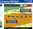
The way I see it, there are 3 areas to watch tomorrow. All of which are very capable of significant severe weather.
Southern and eastern Texas: potentially a dual dryline setup, though both appear to be weak in terms of gradient. Main threat is a very VERY nasty QLCS with some supercells sprinkled in, with large hail and damageing winds being the main show. However if convection can fire in the warmsector from increased forcing and stay discrete then the tornado threat would certainly increase, and a strong tornado cannot be ruled out if a supercell anchors itself in the warm sector.
Southeastern KS and southwestern MO: Volitile environment but discrete convection is in question, with it being just as likely nothing fires at all. And if it stays elevated then hail will be the main threat. However, surface based storms would have the potential for a few strong tornadoes if they can root and mature.
Central+Northern Illinois and North/Northwest Indiana: Given the environment at play, any supercell remotely near or along the warm front would have a volitile combination of instability and shear to work with, and several strong tornadoes are possible with any discrete/semi-discrete supercell, and a violent tornado cannot be ruled out.