
Navigation
Install the app
How to install the app on iOS
Follow along with the video below to see how to install our site as a web app on your home screen.
Note: This feature may not be available in some browsers.
More options
-
Welcome to TalkWeather! We see you lurking around TalkWeather! Take the extra step and join us today to view attachments, see less ads and maybe even join the discussion. CLICK TO JOIN TALKWEATHER
You are using an out of date browser. It may not display this or other websites correctly.
You should upgrade or use an alternative browser.
You should upgrade or use an alternative browser.
Severe Weather 3/4 - 3/8
- Thread starter Sharpy
- Start date
Kds86z
Member
Kds86z
Member
GFS and NAM still sticking to their respective, disparate solutions at 12Z. Man, this is annoying. Normally I'd lean toward the NAM at this close range, but IIRC the GFS did pretty well with the recent Eastern snowstorm so maybe it's on a roll.
They are also quite far apart on the timing. GFS has the dryline far eastern Kansas/Oklahoma by 0Z Saturday, while the NAM has it stlll back well west of I-35 at that time.
Kds86z
Member
Kds86z
Member
5% tornado introduced for outlook just out.
EVEN WITH THESE POTENTIAL LIMITATIONS, A BROAD AREA OF ISOLATED TO
SCATTERED SEVERE THUNDERSTORM POTENTIAL EXISTS THROUGH TONIGHT. AN
ISOLATED AND/OR OCCASIONAL HAIL THREAT MAY PERSIST WITH ONGOING
ELEVATED CONVECTION FROM SOUTHERN MISSOURI INTO SOUTHERN
INDIANA/NORTHERN KENTUCKY. SURFACE-BASED THUNDERSTORM DEVELOPMENT
SHOULD OTHERWISE BECOME MORE PROBABLE ACROSS THE OZARKS INTO
MID/LATE AFTERNOON CLOSER TO THE SURFACE FRONT/SURFACE LOW AND
MODIFYING OUTFLOW. A MIX OF SUPERCELLS AND CLUSTERS WILL POSE A RISK
FOR LARGE HAIL. DAMAGING WINDS WILL ALSO BE POSSIBLE WHERE STEEPENED
LOW-LEVEL LAPSE RATES CAN DEVELOP WITH DAYTIME HEATING. ALTHOUGH
LOW-LEVEL FLOW IS NOT FORECAST TO BECOME OVERLY STRONG, THERE SHOULD
BE SUFFICIENT 0-1 KM SRH TO SUPPORT SOME THREAT FOR A COUPLE OF
TORNADOES WITH ANY SUSTAINED SUPERCELLS/CLUSTERS, PARTICULARLY
ACROSS SOUTHERN MISSOURI AND NORTHERN ARKANSAS.
..GUYER/WENDT.. 03/04/2026
Attachments
Kds86z
Member
Central Ohio Wx
Member
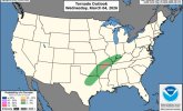
First hatched tornado threat of the new outlooks for D2:

sripey
Member
Correct me if I'm wrong, but doesn't that make this the first hatched 5%?
And into the 2% as well.
Kds86z
Member
I kind of wish they’d add the significance parameters in the guidance chart at bottom right for each risk type. I’m too old to memorize new things…First hatched tornado threat of the new outlooks for D2:
View attachment 50956
N0mz
Member
They actually used to do 5% hatching way long ago. For example the Parkersburg day outlook had a pretty large area of 5% hatching in the panhandle region:Correct me if I'm wrong, but doesn't that make this the first hatched 5%?

joshoctober16
Member
not only its the first hatch risk its also the first 2% and 5% hatch risk.First hatched tornado threat of the new outlooks for D2:
View attachment 50956
Curious about Oklahoma native @andyhb 's thoughts on this set up. And here's the probabilistic for Friday. Broyles is definitely not backing down. It's interesting he's written every outlook leading up to this day. You don't usually see that. I wonder if that's because other forecasters disagree with him or because they're deferring to his expertise on this one.
Edit: As I was writing this comment the afternoon outlook came out and this time it's Grams

He's a lot less sold on the tornado threat it seems
Edit: As I was writing this comment the afternoon outlook came out and this time it's Grams
He's a lot less sold on the tornado threat it seems
Available D3 CAM guidance is much less robust than parameterized models with the degree of convective development through early evening towards the Red River and southward into central TX. With near neutral mid-level height falls, it is plausible that convection south of the latitudinally compact mid-level jetlet will remain isolated. This lowers confidence in the southern extent of highlighted level 3-ENH risk across most of OK.
Across eastern KS, northern OK, and western Missouri, initial supercells will probably grow upscale into a broader QLCS during the evening, with semi-discrete activity favored along the southern flank. Strengthening 850-700 mb southwesterlies suggest damaging wind and QLCS tornado potential could persist across the Mid-MS Valley towards the Lake MI vicinity overnight in a weak MLCAPE/high shear environment. Available CAM guidance does indicate a general alignment of QLCS with the deep-layer shear vector, suggesting of a sporadic severe threat mainly where embedded bowing segments/surges can develop.
Farther south, storm development will become increasingly probable as the accelerating cold front overtakes and merges with the front on Friday night. Outside of frontal convergence and low-level warm advection atop the undercutting front in western TX, large-scale ascent should remain nebulous. Large hail may accompany initial updrafts, with severe wind/tornado potential nocturnally limited.
Ozonelayer
Member
Im sticking with Broyles on this one. There is definetely potential for one to a few strong tornadoes in my opinion.Curious about Oklahoma native @andyhb 's thoughts on this set up. And here's the probabilistic for Friday. Broyles is definitely not backing down. It's interesting he's written every outlook leading up to this day. You don't usually see that. I wonder if that's because other forecasters disagree with him or because they're deferring to his expertise on this one.
Edit: As I was writing this comment the afternoon outlook came out and this time it's Grams
View attachment 50960
He's a lot less sold on the tornado threat it seems
CheeselandSkies
Member
They actually used to do 5% hatching way long ago. For example the Parkersburg day outlook had a pretty large area of 5% hatching in the panhandle region:
View attachment 50958
Yup, it's been done before although technically it shouldn't have been because it was mathematically impossible (you can't have a 10% or greater probability of EF2+ tornadoes within 25 miles of a point when your probability of any tornado within 25 miles of a point is less than 10%). That's one of the issues the new system is designed to address.
Cyclonic Paracosm
Member
wasn't they a thing like idk 20 some years ago then they were did away with?Yup, it's been done before although technically it shouldn't have been because it was mathematically impossible (you can't have a 10% or greater probability of EF2+ tornadoes within 25 miles of a point when your probability of any tornado within 25 miles of a point is less than 10%). That's one of the issues the new system is designed to address.