• Welcome to TalkWeather!
    We see you lurking around TalkWeather! Take the extra step and join us today to view attachments, see less ads and maybe even join the discussion.
    CLICK TO JOIN TALKWEATHER

Severe Weather 3/4 - 3/8

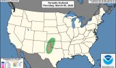
Holy Guacamole! would you look at that warm sector. Both Euro and GFS in agreement there. I'm pulling tornado soundings on the NAM in Iowa, Kansas, Oklahoma, Missouri, Arkansas, Illinois, and Louisiana, which makes sense when you look at the dryline it's projecting

View attachment 50932View attachment 50935
View attachment 50936

Looks like your NAM frame is valid for 06Z Saturday (midnight) for some reason, but even there you can see how it has a much more SW-NE, cold-fronty setup whereas the GFS' more N-S oriented dryline would be much more favorable for a widespread significant severe/tornado event.
 
The first 5% tor on the new graphics.

DUE TO THE SYSTEM IN THE WESTERN U.S. AND THE ASSOCIATED
SOUTHWESTERLY FLOW AHEAD OF IT, A STRONG LOW-LEVEL JET IS FORECAST
TO DEVELOP DURING THE LATE AFTERNOON AND EARLY EVENING ACROSS THE
SOUTHERN PLAINS. THIS FEATURE WILL CONTRIBUTE TO MODERATE DEEP-LAYER
SHEAR OVER MUCH OF THE SOUTHERN HIGH PLAINS. NAM FORECAST SOUNDINGS
IN THE EARLY EVENING FROM EAST OF LUBBOCK NORTHWARD INTO THE TEXAS
PANHANDLE HAVE GRADUALLY VEERING WINDS IN THE LOW TO MID-LEVELS WITH
AROUND 35 KNOTS OF 0-6 KM SHEAR. IN ADDITION, 700-500 MB LAPSE RATES
ARE FORECAST TO BE IN THE 7 TO 8 C/KM RANGE. THIS WILL BE FAVORABLE
FOR SUPERCELLS WITH LARGE HAIL AND ISOLATED SEVERE GUSTS. IN THE
LATE AFTERNOON/EARLY EVENING, 0-3 KM STORM-RELATIVE HELICITY IS
FORECAST TO BE IN THE 250 TO 300 M2/S2 RANGE, WHICH WILL LIKELY
SUPPORT A TORNADO THREAT WITH THE MOST INTENSE STORMS. AS LOW-LEVEL
MOISTURE INCREASES ACROSS PARTS OF SOUTHERN AND CENTRAL KANSAS
DURING THE EVENING, ADDITIONAL STRONG TO SEVERE THUNDERSTORMS ARE
EXPECTED TO DEVELOP. A SEVERE THREAT MAY EVENTUALLY AFFECT CENTRAL
OKLAHOMA AND CENTRAL TO EASTERN KANSAS FROM MID EVENING INTO THE
OVERNIGHT PERIOD.


Attachments

  • IMG_5170.jpeg
    IMG_5170.jpeg
    96.4 KB · Views: 0
For some reason, all of eastern Kentucky is under a tornado warning.
View attachment 50945
PRECAUTIONARY/PREPAREDNESS ACTIONS...

* This is a test message. Test tornado warning for...All counties in
Kentucky

* UNTIL 1030 AM EST

* This is a test message.

This is a test message. This is a test tornado warning message.
There is no severe weather occurring at this time. This test warning
message is part of the annual Kentucky tornado drill.
I know they test the sirens here too but I don't think I've ever seen a test Tornado Warning issued
 
i think its the drill they were talking about
Yeah probably. Still a wild thing to see first thing on radar lol.

Anywho, the NAM is painting a more than enough tornadic environment on Friday Night-Saturday Morning through Eastern KS/OK CODNEXLAB-FORECAST-2026030412-NAM-US-con-stp-57-75-100.gif

Taken in Southeast KS:
2026030412_NAM_063_37.62,-96.74_winter_mu.png

Taken in Northern OK:
2026030412_NAM_063_36.47,-96.11_winter_mu.png
 
what about northern illinois? i saw that cape values reach up to almost like 1300 or something, is that enough to produce something?

Here's what Mr. B. at SPC had to say about that:

...Ozarks/Mid to Upper Mississippi Valley...
Moisture advection will continue throughout the day on Friday into
the evening across the mid to Upper Mississippi Valley. During the
mid to late evening, thunderstorms will begin to spread eastward
into the region. Surface dewpoints in the 60s F, MLCAPE in the 500
to 1000 J/kg range, and moderate to strong deep-layer shear will be
favorable for a severe threat. Some model forecasts suggest that an
intense convective line will move eastward into the Ozarks and mid
to upper Mississippi Valley during the mid to late evening. Under
this scenario, supercells embedded in the line would be capable of
large hail. Severe wind gusts and an isolated tornado threat will
also be possible with the faster moving sections of the line,
especially with bowing segments.
 
Gonna be in Paris when Friday unfolds, but hoping I'll be able to track it regardless. Potential is there for something conditionally significant. Streamwise vort lacks in the lowest km tomorrow but venting may compensate and continue a sigtor threat tomorrow too
 
Here's what Mr. B. at SPC had to say about that:

...Ozarks/Mid to Upper Mississippi Valley...
Moisture advection will continue throughout the day on Friday into
the evening across the mid to Upper Mississippi Valley. During the
mid to late evening, thunderstorms will begin to spread eastward
into the region. Surface dewpoints in the 60s F, MLCAPE in the 500
to 1000 J/kg range, and moderate to strong deep-layer shear will be
favorable for a severe threat. Some model forecasts suggest that an
intense convective line will move eastward into the Ozarks and mid
to upper Mississippi Valley during the mid to late evening. Under
this scenario, supercells embedded in the line would be capable of
large hail. Severe wind gusts and an isolated tornado threat will
also be possible with the faster moving sections of the line,
especially with bowing segments.

Yeah, up north, there isn't enough forcing (look at the diffluence aloft, it's basically zero) for open warm sector storms, and the cold front is way too fast to have any semi-discrete activity. Almost only a wind threat.
 
GFS and NAM still sticking to their respective, disparate solutions at 12Z. Man, this is annoying. Normally I'd lean toward the NAM at this close range, but IIRC the GFS did pretty well with the recent Eastern snowstorm so maybe it's on a roll.

They are also quite far apart on the timing. GFS has the dryline far eastern Kansas/Oklahoma by 0Z Saturday, while the NAM has it stlll back well west of I-35 at that time.
 
Back
Top