
Navigation
Install the app
How to install the app on iOS
Follow along with the video below to see how to install our site as a web app on your home screen.
Note: This feature may not be available in some browsers.
More options
-
Welcome to TalkWeather! We see you lurking around TalkWeather! Take the extra step and join us today to view attachments, see less ads and maybe even join the discussion. CLICK TO JOIN TALKWEATHER
You are using an out of date browser. It may not display this or other websites correctly.
You should upgrade or use an alternative browser.
You should upgrade or use an alternative browser.
Severe Weather 3/15 - 3/16
- Thread starter CheeselandSkies
- Start date
KevinH
Member
I believe you, lolIt updated I swear as soon as I clicked post . I was pulling the text from the NWS FTP server which tends to be a minute or so quicker than the website
I know there is a delay ha
WeathermanLeprechaun
Member
06z HRRR isn't really impressive as a whole for the QLCS. It still suggests paltry instability but easy sig damaging wind potential as the LLJ ramps up.
But it does suggest conditional prefrontal potential at 06z for Alabama.
But it does suggest conditional prefrontal potential at 06z for Alabama.
WeathermanLeprechaun
Member
What's interesting is that the NAM suggests a more broken line on Monday but it doesn't fire prefrontals like this. Wonder if it isn't handling prefrontal convection then on Monday wellYeah, no thanks. Worst of both worlds, strongly-forced QLCS and some prefrontals.
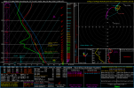
View attachment 51777
WeathermanLeprechaun
Member
06z nam is impressive for Alabama once again.
WeathermanLeprechaun
Member
Things firing prefrontals in S Central AL ahead of the line. Really beginning to gain confidence on a strong tor threat set up around there.06z nam is impressive for Alabama once again.
Yeah the nam has been rather consistent with it. I think right now the nam is probably the best to look at until we get a little closer and then the HRRR will probably the one to go with. Interestingly the RAP as well as the NAM now have the moderate instability, the hrrr is underdone compared to those from but the prefrontals and possibly semi broken line of the nam is a dangerous setup.Things firing prefrontals in S Central AL ahead of the line. Really beginning to gain confidence on a strong tor threat set up around there.
*Rap also hints at prefrontals too
tennessee storm chaser
Member
- Messages
- 1,877
- Reaction score
- 4,288
- Location
- jackson tennessee
- Special Affiliations
- SKYWARN® Volunteer
Being honest , hrrr has t been at its best lately either . But we seeYeah the nam has been rather consistent with it. I think right now the nam is probably the best to look at until we get a little closer and then the HRRR will probably the one to go with. Interestingly the RAP as well as the NAM now have the moderate instability, the hrrr is underdone compared to those from but the prefrontals and possibly semi broken line of the nam is a dangerous setup
National weather service of Birmingham is rather bullish in the morning discussion.
Yeah, that'll get your attention pretty quick.National weather service of Birmingham is rather bullish in the morning discussion.

KevinH
Member
Post. GRAPHICS!!!!! lol06z nam is impressive for Alabama once again.
KevinH
Member
When did ads start showing up IN and before a persons reply? 

Only $5 a month to be a sustaining member and no ads!
KevinH
Member
I've seen the ads before but I don't remember them being RIGHT INSIDE OF THE REPLY lolOnly $5 a month to be a sustaining member and no ads!
No worries... just caught me off guard (finally???)
Ok, back to the WEATHER.
- Moderator
- #419
Here is the BMX morning AFD that Uncle JuJu referenced:
Widespread severe weather looks likely Sunday night, as a very
fast line of storms moves through the region. Damaging winds are the
main threat, with the tornado threat not far behind it.
In a rare instance, the SPC sent out a massive Day 3 update, bumping
portions of our region into an Enhanced Risk (Level 3/5), with a
Slight Risk (Level 2/5) everywhere else. This large upgrade is not
unwarranted, as a very deep trough and low pressure will begin
working into the Midwest by Sunday afternoon. As storms become more
organized along, and ahead of the cold front, this trough will pick
up more and more speed. The result currently appears to be a large
portion of the lower Midwest and Deep South under the threat for
widespread damaging winds and tornadoes.
Locally, the current thinking is that the line of storms should
begin to work into the area between 8-10 PM. These storms will be
moving very fast, and the speed of these storms will no doubt
influence the threat for damaging winds. When it comes to the
tornado threat, this is where guidance starts to differ. Due to
timing issues, and questions regarding instability, the potential
tornado threat may be limited to along the main line. However,
given forecast wind profiles, if any storms were to develop ahead
of the line, they would almost certainly be supercellular in
nature. Again, given the speed of this main line, it may not take
much time at all for these storms to become undercut. Regardless,
these single cell storms would pose a tornado threat as well,
particularly in our SE counties. For now, the most likely scenario
is embedded tornadoes along the main line of thunderstorms. With
all of that being said, I don`t want to downplay the damaging wind
threat given the upper- level environment. This line could easily
produce widespread wind damage across the region, during a time
of day where most people have their guard down.
The whole idea of the front undercutting the storms/cells ahead of the line is a very warrantable one….while the tornado threat is there, I really think at this point, bowing segments will be the primary mode but bookend vortices/Alf’s are certainly possible…if not likely