O boy..... If into that thread you go, only pain and suffering will you find.....
Follow along with the video below to see how to install our site as a web app on your home screen.
Note: This feature may not be available in some browsers.

Apparently this tornado happened yesterday??????


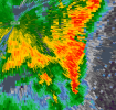
shockingly your not looking at a pileus but a velum cloudRare iridescent pileus in Nebraska on Stormrunner's feed.
 www.bbc.com

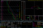
Is this sarcasm? This is a capped out parameter space, and there's no storm motion either on the hodograph!Day 7 looks much more interesting in terms of tornado. Some very eyebrow raising sheer profiles over Eastern Iowa/Illinois.
View attachment 54731
yeah its too capped , however there are instances that could do it with almost the same amount of capping as long as the MLCIN is not lower then -500 (or higher , Example -501) and if the MLCAPE is at 1500 as well as the LR 0-3 at over 8 , however its not at that level for LR so it wouldn't work. but then again the convective temperature is at a insane high.Is this sarcasm? This is a capped out parameter space, and there's no storm motion either on the hodograph!
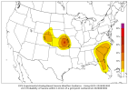
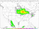
Gotta watch those 45% Nipples...... LOL!Interesting signal on the Day 6 CIPS. Random little 45% nipple. Definitely don't see those probabilities this far out very often.
This is a day that has also looked quite interesting on the GEFS ensemble SCP for a dozen or so runs now. The latest run has more certainty on location, but less certainty about the actual existence of a severe weather threat, with multiple members now showing nothing at all. Similar nipple presentation on the mean SCP.
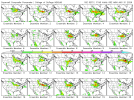
View attachment 54728View attachment 54729View attachment 54730
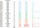
We should get a more active Fall severe weather season. No one is questioning that. However, it's just how active from a tornadic perspective will it be is the question. Let's take a look at that. These are the total tornadoes for the state of MS during El Nino years. I looked at our most active months (October, Nov, Dec, March, April, and May). Basically, Fall and Spring. Based on this, Mississippi sees less tornadoes (only 164 or 9%) during very strong El Ninos than Strong/Mod with most occurring during Weak (859 or 48%). Now, why would that be? The answer: because of your strong subtropical jet which is why the Gulf Coast and Florida sees more tornadic activity than further inland due to more flooding rains/overcast conditions. It makes perfect sense too if you think about it. I just did Mississippi, but I would imagine Alabama is pretty much the same.
We should get a more active Fall severe weather season. No one is questioning that. However, it's just how active from a tornadic perspective will it be is the question. Let's take a look at that. These are the total tornadoes for the state of MS during El Nino years. I looked at our most active months (October, Nov, Dec, March, April, and May). Basically, Fall and Spring. Based on this, Mississippi sees less tornadoes (only 164 or 9%) during very strong El Ninos than Strong/Mod with most occurring during Weak (859 or 48%). Now, why would that be? The answer: because of your strong subtropical jet which is why the Gulf Coast and Florida sees more tornadic activity than further inland due to more flooding rains/overcast conditions. It makes perfect sense too if you think about it. I just did Mississippi, but I would imagine Alabama is pretty much the same.
The numbers beside the Type of ENSO column are the combined totals for the 2 years (51-52) for October, Nov, Dec, March, April, and May. The combined total as in Oct, Nov, Dec, Mar, April, and May. Then I got the grand total when I added those up. The color coded wording, numbers, and percentages is where I just reordered them in order (Weak to Very Strong ENSO).What are the columns here? Is the 3rd column Fall tornadoes?
Evidence of this occuring was back in 2016. We had the Appomattox EF3 and we also had the outbreak in April that produced multiple sig tornadoes including the Elon EF3 that tracked literally the neighborhood next to me.Interestingly, Virginia, Florida, and Louisiana seem to have pretty notable tornado activity during strong El Ninos. Though overall it kinda seems like they actually trigger tornado activity across the board.