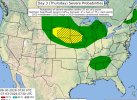
• Welcome to TalkWeather!
    We see you lurking around TalkWeather! Take the extra step and join us today to view attachments, see less ads and maybe even join the discussion.
    CLICK TO JOIN TALKWEATHER

Severe Weather 2026

Day 3:

..BLACK HILLS INTO IOWA/MINNESOTA

A SUBTLE SHORTWAVE TROUGH IS EVIDENT IN MODEL GUIDANCE. THIS FEATURE
WILL MOVE INTO WYOMING/MONTANA AND EVENTUALLY THE WESTERN DAKOTAS.
CONVECTION APPEARS LIKELY TO DEVELOP WITHIN THE HIGHER TERRAIN (BIG
HORNS/BLACK HILLS) AND MOVE INTO AN AIRMASS WITH INCREASINGLY RICH
LOW-LEVEL MOISTURE TO THE EAST. CONVECTION SHOULD BE ABLE TO
ORGANIZE ALONG THE SURFACE BOUNDARY WITH AROUND 40 KT OF EFFECTIVE
SHEAR PARALLEL TO THE BOUNDARY ITSELF. ADDITIONAL CONVECTION IS ALSO
POSSIBLE ALONG THE STATIONARY FRONT AS LOW-LEVEL WARM ADVECTION
INCREASES. THOUGH THERE IS SOME VARIABILITY IN WHERE ANY EVENTUAL
MCS WILL PROPAGATE, THERE IS ENOUGH CONFIDENCE TO INCLUDE A 15%
SEVERE PROBABILITY AREA THAT ENCOMPASSES THE ENVELOPE OF POTENTIAL
TRACKS. THE ENVIRONMENT WOULD SUPPORT SIGNIFICANT HAIL WITH
SUPERCELLS AND SIGNIFICANT WINDS WITH AN ORGANIZED MCS.
 

Attachments

  • IMG_0597.jpeg
    IMG_0597.jpeg
    181.8 KB · Views: 1
I missed this upgrade, now 5% tornado probs.

WI AND POSE A SEVERE RISK OF DAMAGING WINDS. OR, IT COULD
WEAKEN AND ADDITIONAL SEVERE STORMS COULD DEVELOP NEAR THE SURFACE
BOUNDARY ACROSS WI/NORTHERN MI DURING THE DAY. ANOTHER ROUND OF
CONVECTION IS EXPECTED TO DEVELOP DURING THE EVENING ACROSS SOUTHERN
MN. THIS ACTIVITY COULD INITIALLY BE SUPERCELLS, WITH AN
ACCOMPANYING ALL-HAZARDS SEVERE RISK. HOWEVER, STORMS ARE EXPECTED
TO QUICKLY GROW UPSCALE INTO A BOWING MCS, MOVING EAST/NORTHEAST
THROUGH THE NIGHTTIME HOURS ACROSS WI/MI.


@CheeselandSkies
 
Last edited:
12Z 06/30 - 12Z 07/01

Prevots
(a kind of SPC, but from Brazil) has just issued a Level 3 severe risk (equivalent to the SPC’s enhanced risk) in its convective outlook today for parts of Paraná and Santa Catarina (and, based on the map, the risk area would also cover neighboring countries, more specifically eastern Paraguay and the Argentine Panhandle) with all svr possible from now until well into the night.
The first half of the event (noon-afternoon) will be dominated by semi-discrete supercells capable of producing large hail, torrential rain, violent gusts, and tornadoes (some of them strong). In the second half (afternoon–night), the stationary front will begin to advance as a cold front, sweeping everything in its path in the form of several bow echoes.

 
Just a glimpse of the (officially uncounted) skinny rope near West Liberty, IA on April 2 (my chase partner got a photo as I was driving, chasers who were closer got video of a ground circulation with it but it's not on the NWS' survey list, the tornado near Downey that they list was further west and about 5 minutes earlier)

...and the EF1 near Truman, MN on April 13 after hauling all the way from starting the day in Wichita after my tour ended in OKC the previous evening.

EF1 Tornado near Truman, MN 4/13/2026 1 by Andy, on Flickr


Worth noting I would have missed both of these had I followed through with my original plan of flying Madison-OKC on 4/2 and OKC-Madison on 4/13. I ended up bailing on my flight booking last minute, eating the nearly $400 fare and driving instead, missing the first several days of the tour (the only chase day out of that was Friday 4/3, the first day of the tour on which they had to marathon haul OKC-Iowa for the best tornado chances, which still didn't pan out).
 
been a lot of supercells lately around the new brunswick canada radar

1782856689858.png

one already got rated EF0 and there is a possible report of a other one that happen on the same day as that one.

for now this supercell has no town or cities in its path.
 
Back
Top