

Navigation
Install the app
How to install the app on iOS
Follow along with the video below to see how to install our site as a web app on your home screen.
Note: This feature may not be available in some browsers.
More options
-
Welcome to TalkWeather! We see you lurking around TalkWeather! Take the extra step and join us today to view attachments, see less ads and maybe even join the discussion. CLICK TO JOIN TALKWEATHER
You are using an out of date browser. It may not display this or other websites correctly.
You should upgrade or use an alternative browser.
You should upgrade or use an alternative browser.
Severe Weather 2026
- Thread starter KevinH
- Start date

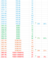
It was not that long ago, I questioned just how active the Fall tornado season could be. Which is why I did this Spreadsheet on MS tornadoes during the Fall and Spring months during weak, moderate, strong, and very strong El Ninos. Turns out you have more activity during weak El Ninos than very strong El Ninos. Why? Because of the subtropical jet being more of a player with strong/very strong El Ninos leading to more cloud cover issues/heavy rain events inland limiting any tornadic activity closer to the Gulf Coast/Florida. That doesn't mean you can't or won't have severe weather threats going forward. It's just gonna be much harder to do.
Attachments
tennessee storm chaser
Member
- Messages
- 1,923
- Reaction score
- 4,419
- Location
- jackson tennessee
- Special Affiliations
- SKYWARN® Volunteer
Well saidIt was not that long ago, I questioned just how active the Fall tornado season could be. Which is why I did this Spreadsheet on MS tornadoes during the Fall and Spring months during weak, moderate, strong, and very strong El Ninos. Turns out you have more activity during weak El Ninos than very strong El Ninos. Why? Because of the subtropical jet being more of a player with strong/very strong El Ninos leading to more cloud cover issues/heavy rain events inland limiting any tornadic activity closer to the Gulf Coast/Florida. That doesn't mean you can't or won't have severe weather threats going forward. It's just gonna be much harder to do.

WeathermanLeprechaun
Member
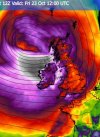
Westerly jet stream may lead to a conditional risk of a damaging windstorm or two this late Oct around my vicinity. Uncertainties around where the lows actually track but I'm thinking a good chance for a deep low close to us. Although the weather weenie in me wants this thing big time. I am hungry for some loud gusts/squall lines, man.
Kds86z
Member
@JPWXIt was not that long ago, I questioned just how active the Fall tornado season could be. Which is why I did this Spreadsheet on MS tornadoes during the Fall and Spring months during weak, moderate, strong, and very strong El Ninos. Turns out you have more activity during weak El Ninos than very strong El Ninos. Why? Because of the subtropical jet being more of a player with strong/very strong El Ninos leading to more cloud cover issues/heavy rain events inland limiting any tornadic activity closer to the Gulf Coast/Florida. That doesn't mean you can't or won't have severe weather threats going forward. It's just gonna be much harder to do.
There's my point. Regarding 2015, the only noteworthy severe weather event for North MS/Mid-South was December 23rd with the Holly Springs tornado. Then on Christmas Day, we got flooded. To this day, I have not had a higher 24 hour total rainfall amount than I had on Christmas Day that year. I ended up with a whopping 8.75 inches of rain that day. In fact, it was the first time ever I had to empty my rain gauge while it was still raining so it wouldn't overflow.
Kds86z
Member
Oh holly springs was during El Niño didn’t realizeThere's my point. Regarding 2015, the only noteworthy severe weather event for North MS/Mid-South was December 23rd with the Holly Springs tornado. Then on Christmas Day, we got flooded. To this day, I have not had a higher 24 hour total rainfall amount than I had on Christmas Day that year. I ended up with a whopping 8.75 inches of rain that day. In fact, it was the first time ever I had to empty my rain gauge while it was still raining so it wouldn't overflow.

Cyclonic Paracosm
Member
wut abt Garland Texas like 2 days before?There's my point. Regarding 2015, the only noteworthy severe weather event for North MS/Mid-South was December 23rd with the Holly Springs tornado. Then on Christmas Day, we got flooded. To this day, I have not had a higher 24 hour total rainfall amount than I had on Christmas Day that year. I ended up with a whopping 8.75 inches of rain that day. In fact, it was the first time ever I had to empty my rain gauge while it was still raining so it wouldn't overflow.
- Moderator
- #2,869

There's my point. Regarding 2015, the only noteworthy severe weather event for North MS/Mid-South was December 23rd with the Holly Springs tornado. Then on Christmas Day, we got flooded. To this day, I have not had a higher 24 hour total rainfall amount than I had on Christmas Day that year. I ended up with a whopping 8.75 inches of rain that day. In fact, it was the first time ever I had to empty my rain gauge while it was still raining so it wouldn't overflow.
We had massive flooding that December too and people here still talk about the "Christmas floods." Over 8 inches of rain in 24 hours. I'm 53 and that's the worst I've ever seen it.

CheeselandSkies
Member
wut abt Garland Texas like 2 days before?
It was actually 3 days later, on the 26th.

2015 Garland tornado - Wikipedia
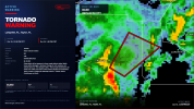
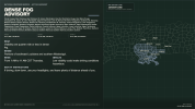
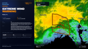
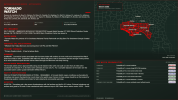
So I want to reveal to you all a project I've had and continuing to work on. Short Story as to how this all came about: I've always wanted my own weather graphics and before all this happened, I was using MetGraphics which I loved. However, it was taken up too much time building the graphics in PowerPoint and I couldn't afford the fancy Baron graphics (would have had to rob the federal reserve for that one LOL). Anyways, I had a friend who was gonna help me and had a solution. Unfortunately, I never had any response back as to what that solution might intel. So enter AI. I had never fooled with AI and really never planned to. To be completely honest, I didn't know what to expect going into this venture. I teared up when I saw how quickly and fast it could build what I needed. A few weeks before Hurricane Isaias, I did a total revamp of the warning/watch graphic. The inserted image is before: 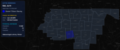 Here's a few pics of my new updated graphics. I've made some tweaks and adjustments for a few reasons: 1. to make it easier for me, 2. to look more professional, and 3. to consolidate into one image (like you see with the wind advisories and marine warnings). That's what I've done today is to consolidate. Just wanted to share this.
Attachments
-
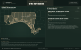 wind-advisory-2026-10-17T21-32-37-857Z.png1.8 MB · Views: 10
-
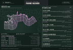 marine-hazards-2026-10-17T21-31-07-639Z.png2.3 MB · Views: 11
-
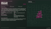 red-flag-warning-urn-oid-2-49-0-1-840-0-b0f85bb09a2e599015083241d7978969d1428e11-001-2-2026-10...png1.1 MB · Views: 16
-
 tornado-warning-radar-2026-10-10-17-37.png1.8 MB · Views: 16
-
 dense-fog-advisory-urn-oid-2-49-0-1-840-0-10b49036869235489532d574c62981e507375307-001-1-2026-...png1.1 MB · Views: 15
-
 extreme-wind-warning-radar-2026-10-10-00-51.png1.9 MB · Views: 16
-
 tornado-watch-urn-oid-2-49-0-1-840-0-6ebabec05fb63982486beac6dc8e66fe5e878320-001-1-2026-10-09...png1.4 MB · Views: 20
- Moderator
- #2,872
So I want to reveal to you all a project I've had and continuing to work on. Short Story as to how this all came about: I've always wanted my own weather graphics and before all this happened, I was using MetGraphics which I loved. However, it was taken up too much time building the graphics in PowerPoint and I couldn't afford the fancy Baron graphics (would have had to rob the federal reserve for that one LOL). Anyways, I had a friend who was gonna help me and had a solution. Unfortunately, I never had any response back as to what that solution might intel. So enter AI. I had never fooled with AI and really never planned to. To be completely honest, I didn't know what to expect going into this venture. I teared up when I saw how quickly and fast it could build what I needed. A few weeks before Hurricane Isaias, I did a total revamp of the warning/watch graphic. The inserted image is before: View attachment 55342Here's a few pics of my new updated graphics. I've made some tweaks and adjustments for a few reasons: 1. to make it easier for me, 2. to look more professional, and 3. to consolidate into one image (like you see with the wind advisories and marine warnings). That's what I've done today is to consolidate. Just wanted to share this.
I am not a fan of AI - at all - but even I have to admit that's pretty awesome.
Kds86z
Member
Day 3
SCATTERED SHOWERS AND STORMS MAY BE ONGOING OVER NORTHERN AZ
WEDNESDAY MORNING, AIDED BY UPSLOPE WINDS. FURTHER DESTABILIZATION
IS LIKELY DURING THE DAY, WITH EXPANDING STORM COVERAGE OVERALL.
FAVORABLE DEEP-LAYER SHEAR OVER 50 KT WITH ELONGATED HODOGRAPHS WILL
FAVOR A FEW SUPERCELLS PRODUCING HAIL. A TORNADO OR TWO MAY OCCUR
ESPECIALLY OVER THE ELEVATED TERRAIN WHERE LCL HEIGHTS WILL BE
LOWER.
INSTABILITY AND PLACEMENT/TIMING OF THE GREATEST THREAT AREA IS A
BIT UNCERTAIN, BUT INCREASED SEVERE PROBABILITIES MAY OCCUR IN LATER
UPDATES AS THE EVENT NEARS.
SCATTERED SHOWERS AND STORMS MAY BE ONGOING OVER NORTHERN AZ
WEDNESDAY MORNING, AIDED BY UPSLOPE WINDS. FURTHER DESTABILIZATION
IS LIKELY DURING THE DAY, WITH EXPANDING STORM COVERAGE OVERALL.
FAVORABLE DEEP-LAYER SHEAR OVER 50 KT WITH ELONGATED HODOGRAPHS WILL
FAVOR A FEW SUPERCELLS PRODUCING HAIL. A TORNADO OR TWO MAY OCCUR
ESPECIALLY OVER THE ELEVATED TERRAIN WHERE LCL HEIGHTS WILL BE
LOWER.
INSTABILITY AND PLACEMENT/TIMING OF THE GREATEST THREAT AREA IS A
BIT UNCERTAIN, BUT INCREASED SEVERE PROBABILITIES MAY OCCUR IN LATER
UPDATES AS THE EVENT NEARS.
BTW this El Nino has peaked or is peaking now. Expect a downtrend next few months.
tennessee storm chaser
Member
- Messages
- 1,923
- Reaction score
- 4,419
- Location
- jackson tennessee
- Special Affiliations
- SKYWARN® Volunteer
Say models have it peaking late November early December . We will see …. But it will persist nearly spring 27…. This pattern sucks. By the way. Been a snooze fest around here .BTW this El Nino has peaked or is peaking now. Expect a downtrend next few months.
Kds86z
Member

KakashiHatake2000
Member
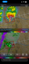
Was posted in r/tornado Reddit too
Kds86z
Member
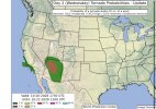
...Desert Southwest to the Four Corners...
Marginal instability should develop through the day, primarily
driven by increasing low-level warm-air and moisture advection
(given ample cloud cover expected). Surface dewpoints should
increase into the 60s F, especially over central AZ, yielding over
1500 J/kg MLCAPE given 7+ C/km mid-level lapse rates. A 50-70 kt
southwesterly 500 mb jet will overspread the warm sector and
accompanying southeasterly antecedent flow, yielding elongated
hodographs with sizeable low-level curvature. Supercell
thunderstorms are expected by late afternoon, accompanied by a
severe wind and hail threat. Given the size of the low-level
hodographs, a tornado or two may also occur.
Kds86z
Member
Kds86z
Member
Now day 3 slight
THERE IS A SLIGHT RISK OF SEVERE THUNDERSTORMS ACROSS PARTS OF
ARIZONA...
..SUMMARY
AT LEAST ISOLATED SEVERE THUNDERSTORMS ARE EXPECTED ACROSS THE
SOUTHWEST AND FOUR CORNERS AREA ON THURSDAY, WITH THE GREATEST RISK
ACROSS PARTS OF ARIZONA.
..ARIZONA AND DESERT SOUTHWEST/GREAT BASIN
A PROMINENT/DEEP LOW-LATITUDE UPPER TROUGH OFF THE COAST OF
CALIFORNIA WILL BECOME MORE NORTHEASTWARD-PROGRESSIVE ON THURSDAY AS
IT MOVES INLAND TOWARD THE LOWER COLORADO RIVER VALLEY. WHILE SOME
WEAKENING OF THE DEEP-LAYER WIND FIELD MAY OCCUR OVER TIME, WIND
PROFILES WILL NONETHELESS REMAIN RATHER SUPPORTIVE OF ORGANIZED
STORM MODES, POTENTIALLY INCLUDING SOME SUPERCELLS AND SUSTAINED
MULTICELLS CAPABLE OF HAIL AND POSSIBLY SOME TORNADO RISK, WHICH MAY
PRIMARILY FOCUS THE FIRST PART OF THE DAY. THESE WIND PROFILES WITH
LONG/SEMI-STRAIGHT HODOGRAPHS WILL SUPPORT AT LEAST SOME SEVERE
POTENTIAL EVEN IF INSTABILITY IS A BIT MUTED BY EARLY DAY CLOUD
COVER AND PRECIPITATION. IT CURRENTLY APPEARS THAT PARTS OF CENTRAL
INTO EASTERN ARIZONA WILL HAVE THE MOST-FAVORABLE SEVERE-WEATHER
INGREDIENTS ON THURSDAY, AND THE LONGEST RELATIVE DURATION THEREOF,
HENCE A CATEGORICAL SLIGHT RISK UPGRADE.
THERE IS A SLIGHT RISK OF SEVERE THUNDERSTORMS ACROSS PARTS OF
ARIZONA...
..SUMMARY
AT LEAST ISOLATED SEVERE THUNDERSTORMS ARE EXPECTED ACROSS THE
SOUTHWEST AND FOUR CORNERS AREA ON THURSDAY, WITH THE GREATEST RISK
ACROSS PARTS OF ARIZONA.
..ARIZONA AND DESERT SOUTHWEST/GREAT BASIN
A PROMINENT/DEEP LOW-LATITUDE UPPER TROUGH OFF THE COAST OF
CALIFORNIA WILL BECOME MORE NORTHEASTWARD-PROGRESSIVE ON THURSDAY AS
IT MOVES INLAND TOWARD THE LOWER COLORADO RIVER VALLEY. WHILE SOME
WEAKENING OF THE DEEP-LAYER WIND FIELD MAY OCCUR OVER TIME, WIND
PROFILES WILL NONETHELESS REMAIN RATHER SUPPORTIVE OF ORGANIZED
STORM MODES, POTENTIALLY INCLUDING SOME SUPERCELLS AND SUSTAINED
MULTICELLS CAPABLE OF HAIL AND POSSIBLY SOME TORNADO RISK, WHICH MAY
PRIMARILY FOCUS THE FIRST PART OF THE DAY. THESE WIND PROFILES WITH
LONG/SEMI-STRAIGHT HODOGRAPHS WILL SUPPORT AT LEAST SOME SEVERE
POTENTIAL EVEN IF INSTABILITY IS A BIT MUTED BY EARLY DAY CLOUD
COVER AND PRECIPITATION. IT CURRENTLY APPEARS THAT PARTS OF CENTRAL
INTO EASTERN ARIZONA WILL HAVE THE MOST-FAVORABLE SEVERE-WEATHER
INGREDIENTS ON THURSDAY, AND THE LONGEST RELATIVE DURATION THEREOF,
HENCE A CATEGORICAL SLIGHT RISK UPGRADE.