

Navigation
Install the app
How to install the app on iOS
Follow along with the video below to see how to install our site as a web app on your home screen.
Note: This feature may not be available in some browsers.
More options
-
Welcome to TalkWeather! We see you lurking around TalkWeather! Take the extra step and join us today to view attachments, see less ads and maybe even join the discussion. CLICK TO JOIN TALKWEATHER
You are using an out of date browser. It may not display this or other websites correctly.
You should upgrade or use an alternative browser.
You should upgrade or use an alternative browser.
Severe Weather 2026
- Thread starter KevinH
- Start date

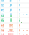
It was not that long ago, I questioned just how active the Fall tornado season could be. Which is why I did this Spreadsheet on MS tornadoes during the Fall and Spring months during weak, moderate, strong, and very strong El Ninos. Turns out you have more activity during weak El Ninos than very strong El Ninos. Why? Because of the subtropical jet being more of a player with strong/very strong El Ninos leading to more cloud cover issues/heavy rain events inland limiting any tornadic activity closer to the Gulf Coast/Florida. That doesn't mean you can't or won't have severe weather threats going forward. It's just gonna be much harder to do.
Attachments
tennessee storm chaser
Member
- Messages
- 1,912
- Reaction score
- 4,382
- Location
- jackson tennessee
- Special Affiliations
- SKYWARN® Volunteer
Well saidIt was not that long ago, I questioned just how active the Fall tornado season could be. Which is why I did this Spreadsheet on MS tornadoes during the Fall and Spring months during weak, moderate, strong, and very strong El Ninos. Turns out you have more activity during weak El Ninos than very strong El Ninos. Why? Because of the subtropical jet being more of a player with strong/very strong El Ninos leading to more cloud cover issues/heavy rain events inland limiting any tornadic activity closer to the Gulf Coast/Florida. That doesn't mean you can't or won't have severe weather threats going forward. It's just gonna be much harder to do.

WeathermanLeprechaun
Member
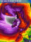
Westerly jet stream may lead to a conditional risk of a damaging windstorm or two this late Oct around my vicinity. Uncertainties around where the lows actually track but I'm thinking a good chance for a deep low close to us. Although the weather weenie in me wants this thing big time. I am hungry for some loud gusts/squall lines, man.
Kds86z
Member
@JPWXIt was not that long ago, I questioned just how active the Fall tornado season could be. Which is why I did this Spreadsheet on MS tornadoes during the Fall and Spring months during weak, moderate, strong, and very strong El Ninos. Turns out you have more activity during weak El Ninos than very strong El Ninos. Why? Because of the subtropical jet being more of a player with strong/very strong El Ninos leading to more cloud cover issues/heavy rain events inland limiting any tornadic activity closer to the Gulf Coast/Florida. That doesn't mean you can't or won't have severe weather threats going forward. It's just gonna be much harder to do.
There's my point. Regarding 2015, the only noteworthy severe weather event for North MS/Mid-South was December 23rd with the Holly Springs tornado. Then on Christmas Day, we got flooded. To this day, I have not had a higher 24 hour total rainfall amount than I had on Christmas Day that year. I ended up with a whopping 8.75 inches of rain that day. In fact, it was the first time ever I had to empty my rain gauge while it was still raining so it wouldn't overflow.
Kds86z
Member
Oh holly springs was during El Niño didn’t realizeThere's my point. Regarding 2015, the only noteworthy severe weather event for North MS/Mid-South was December 23rd with the Holly Springs tornado. Then on Christmas Day, we got flooded. To this day, I have not had a higher 24 hour total rainfall amount than I had on Christmas Day that year. I ended up with a whopping 8.75 inches of rain that day. In fact, it was the first time ever I had to empty my rain gauge while it was still raining so it wouldn't overflow.

Cyclonic Paracosm
Member
wut abt Garland Texas like 2 days before?There's my point. Regarding 2015, the only noteworthy severe weather event for North MS/Mid-South was December 23rd with the Holly Springs tornado. Then on Christmas Day, we got flooded. To this day, I have not had a higher 24 hour total rainfall amount than I had on Christmas Day that year. I ended up with a whopping 8.75 inches of rain that day. In fact, it was the first time ever I had to empty my rain gauge while it was still raining so it wouldn't overflow.
- Moderator
- #2,869

There's my point. Regarding 2015, the only noteworthy severe weather event for North MS/Mid-South was December 23rd with the Holly Springs tornado. Then on Christmas Day, we got flooded. To this day, I have not had a higher 24 hour total rainfall amount than I had on Christmas Day that year. I ended up with a whopping 8.75 inches of rain that day. In fact, it was the first time ever I had to empty my rain gauge while it was still raining so it wouldn't overflow.
We had massive flooding that December too and people here still talk about the "Christmas floods." Over 8 inches of rain in 24 hours. I'm 53 and that's the worst I've ever seen it.

CheeselandSkies
Member
wut abt Garland Texas like 2 days before?
It was actually 3 days later, on the 26th.
