akt1985
Member
Watching some of the NFL games today, gradient winds are quite strong behind the system that came through the Northeast yesterday.Tornado warning in SW PA! The shear somehow worked
Follow along with the video below to see how to install our site as a web app on your home screen.
Note: This feature may not be available in some browsers.
Watching some of the NFL games today, gradient winds are quite strong behind the system that came through the Northeast yesterday.Tornado warning in SW PA! The shear somehow worked
Yeah gusts up to 40 here in PaWatching some of the NFL games today, gradient winds are quite strong behind the system that came through the Northeast yesterday.

Quick note that this version of CIPS actually isn't recommended for use and instead it's the one with "percentage of analogs" and a decently detailed space for parameters and analogs. It's oddly hard to find on Google though. I will share the link when I find it.
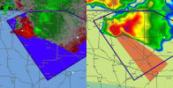
Interesting signals from the HRRR regarding tomorrow.
Surface inversion could limit storms being surface based but aside from that, i can see storm initiation here. It is notable that morning convection does to thru the area but it's a rather robust return for a day that I'm not sure was on many people's eyes before today. We will see. Intrigued if the MO/IL/KY border can do something with this environment tmrw

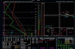
It's all dependant on the warm front. But there is dangerous kinematics at play, even though BRN suggests the possibility of shear dominating the event meaning storms may not sustain well in the hotspot for storms.View attachment 48687
honestly looks pretty severe if no change happens.
events to watch for are events that have a parameter of..
BRN =10 to 45
DBRN = 0.16 to 0.6 (parameter i made , similar to BRN but replace the BWD6 with DCAPE)
LOW + MID RH = 65 to 89
CVTP = 1.813+ (parameter i made , corrected version of VTP)
tend to be the most dangerous events for Type 1 Tornado outbreaks , and this seems to be one of them.
You change the super outbreak parameter to something more useful like MCS or squal line likelihood. Even though it seems psuedo-sciencey it's still fun seeing your concepts evolve over time! Good work!View attachment 48687
honestly looks pretty severe if no change happens.
events to watch for are events that have a parameter of..
BRN =10 to 45
DBRN = 0.16 to 0.6 (parameter i made , similar to BRN but replace the BWD6 with DCAPE)
LOW + MID RH = 65 to 89
CVTP = 1.813+ (parameter i made , corrected version of VTP)
tend to be the most dangerous events for Type 1 Tornado outbreaks , and this seems to be one of them.


SLGT or 5#? If the 5# officially existed, this would be the day to use it in that same corridor that was impacted by the Blodgett-London cell on May 16.Latest outlook mentions a potential upgrade at 20z if confidence in surface based storms close to the low/warm front appear apparent. Sneaky day incoming.
SLGT. Unrelated, but the 5# is being introduced sometime next year. Would absolutely be helpful on days like these.SLGT or 5#? If the 5# officially existed, this would be the day to use it in that same corridor that was impacted by the Blodgett-London cell on May 16.

.jpeg")