• Welcome to TalkWeather!
    We see you lurking around TalkWeather! Take the extra step and join us today to view attachments, see less ads and maybe even join the discussion.
    CLICK TO JOIN TALKWEATHER

Severe Weather 2025

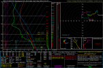
The GFS has been pretty consistent with a broad and highly amplified western trough around the end of the month. 06Z run has pretty impressive hodographs over the southern Plains for next Saturday the 29th. Surface moisture is solid for the time of year (mid 50s with decent depth), but it looks like we'd need to see the surface temperatures be a bit warmer (vs. the generally upper 50s to around 60 depicted on soundings) and/or cooler air aloft push out over the warm sector, to realize sufficient instability.

Tendency is for a positively tilted ejection into the MS Valley (A NE-SW orientation to both the upper-level trough axis and the surface cold front) the following day, however there is a pretty fast jet streak in there (85 kts at 500mb over Iowa). There is also a hint of a possible neutral to slightly negatively tilted shortwave ejecting through the broad SW flow (circled in green).


Screenshot 2025-11-22 093335_marked.jpg

Next thing to watch, anyway...

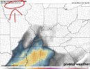
However, that same GFS run also seems to want to develop a hurricane in the Gulf a couple of days later, so hard to trust how it handles the trough evolution at that point.
 
Last edited:
Something interesting i found

https://arxiv.org/html/2510.03349v1

Basically appears to have combined several AI models of sorts to help with forecasting tornado forecasting and the results from days like 3/19, 3/14 that they picked weren't that bad. Synoptically on major days, AI models will find it easier to distinguish tornado risks but on very, gritty mesoscale days, i find they would most likely struggle etc. But the good out of this is pattern recognition for high end, major days is something that AI has got on board. This kinda went under the radar (pun intended) notably, since it was released a month ago close to the Enderlin debacle but a train of thought here
 
A undocumented ef2 was just discovered from the April 15, 2011 tornado outbreak in Alabama, one of our more prolific tornado outbreaks prior to the big one 12 days later on April 27th.

'Frightful day:' Undocumented tornado discovered 14 years after April outbreak https://share.google/XvJKhUeW0HAisUTFS
Yeah old news lol. In a different thread but thanks :)
 
NAM says Tuesday in Dixie could also be interesting with strong low level buoyancy, plus nicely curved low level hodographs. Wouldn't be surprised to see SPC outline D3 slight for that too! NAM likely overdoing instability but regardless, good setup for a few tornadoes.

Regarding Monday, I have questions over storm mode maybe getting a bit too messy but a conditional threat for a few tornadoes exists. We will see. Interesting little period coming up!

Image attached is for Tuesday in Southern Mississippi.
 

Attachments

  • 2025112218_NAM_075_30.91,-90.28_winter_mu.png
    2025112218_NAM_075_30.91,-90.28_winter_mu.png
    74.2 KB · Views: 0
NAM says Tuesday in Dixie could also be interesting with strong low level buoyancy, plus nicely curved low level hodographs. Wouldn't be surprised to see SPC outline D3 slight for that too! NAM likely overdoing instability but regardless, good setup for a few tornadoes.

Regarding Monday, I have questions over storm mode maybe getting a bit too messy but a conditional threat for a few tornadoes exists. We will see. Interesting little period coming up!

Image attached is for Tuesday in Southern Mississippi.
Tuesday has my eyes
 
When do you think 21Z Monday is then?? I said Monday/Tuesday
Monday/Tuesday is this week and you've outlined December 1st in your last photo? Both events admittedly look similar when looking at composite parameters but i was just pointing out your mistake, that's all :/
 

Attachments

  • 1763842073812~2.jpg
    1763842073812~2.jpg
    292 KB · Views: 0
When do you think 21Z Monday is then?? I said Monday/Tuesday

Your other images posted seem to be referencing this coming Monday/Tuesday (11/24-25), rather than a week further out.
 
Monday/Tuesday is this week and you've outlined December 1st in your last photo? Both events admittedly look similar when looking at composite parameters but i was just pointing out your mistake, that's all :/
My mistake. I see what your saying now. I was behind in my time frame Im posted like you said. Sorry about that
 
Last edited:
Not half-bad. Sounding near Anniston at the AL/GA border, 21Z off 18Z GFS. Nothing amazing, but enough for some severe storms with lower-end tornado risk, taken verbatim. Definitely worth watching as we enter Thanksgiving week.
1763862942939.png1763862945637.png1763862953389.png1763862957885.png1763863113925.png
 
Back
Top