WeathermanLeprechaun
Member
Latest thoughts on Monday seem to continue the uncertainty about surface based storms + storm mode. Kinematics aren't bad and are pretty much at the sweet spot for tornadoes. Conditionally a couple tornadoes are possible and models aren't stirring up or down with this. Going into Tuesday, convection should reinvorginate for the Dixie tornado threat. Threat should range for S MS to the northern portion of the state so @JPWX make sure your tornado magnet isn't on!
Jokes aside, the threat up north could be interesting, some sort of 700 mb inversion exists in the thermodynamic profiles. This could clear out messier updrafts and perhaps create a more cleaner storm mode with potential of a couple tornadoes up north. The threat slowly lingers off thru 21z-00z with a tornado or two remaining conditionally possible in Central MS. A sneaky 2nd round MAY be possible in SE MS around 03z, but that threat would still be mainly low end, tornado or two.
Surface based storms should be likely in Mississippi on Tuesday, potentially messier storm mode down south leaves questions. Personally, i wouldn't rule out a large 5% contour perhaps being possible on Tuesday if models remain, it may be your "run of the mill" threat but we've seen what Dixie can do in these situations...
TLDR: Maybe a few tornadoes possible in Eastern TX on Monday then Dixie is back.
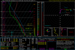
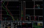
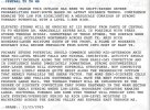
First sounding is taken from Eastern TX on Monday. Second is N MS on Tuesday!
Jokes aside, the threat up north could be interesting, some sort of 700 mb inversion exists in the thermodynamic profiles. This could clear out messier updrafts and perhaps create a more cleaner storm mode with potential of a couple tornadoes up north. The threat slowly lingers off thru 21z-00z with a tornado or two remaining conditionally possible in Central MS. A sneaky 2nd round MAY be possible in SE MS around 03z, but that threat would still be mainly low end, tornado or two.
Surface based storms should be likely in Mississippi on Tuesday, potentially messier storm mode down south leaves questions. Personally, i wouldn't rule out a large 5% contour perhaps being possible on Tuesday if models remain, it may be your "run of the mill" threat but we've seen what Dixie can do in these situations...
TLDR: Maybe a few tornadoes possible in Eastern TX on Monday then Dixie is back.
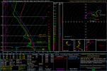
First sounding is taken from Eastern TX on Monday. Second is N MS on Tuesday!