• Welcome to TalkWeather!
    We see you lurking around TalkWeather! Take the extra step and join us today to view attachments, see less ads and maybe even join the discussion.
    CLICK TO JOIN TALKWEATHER

Severe Weather 2025

Globals always underdo moisture return. I just focus more on the 500mb height field at this juncture. The 12z run today on each of the global models definitely looked robust for next weekend/early following week.
 
The kinematics are absolutely impressive, even for Winter events but the main reason is why the kinematics are a bit more impressive is this setup could provide a decent storm mode (making the kinematics maximised in use) but even then, it's a bit far to discuss that but things aren't that bad in terms of the shear vectors. gfs is likely underdoing moisture a bit, and i also have questions over more mesoscale day of things. Morning convection may be a issue, and then comes in airmass recovery etc but that is for the close close range. Hodographs are very classic and should organized thermodynamics become clearer, then my concern will be big. Trends will be key but the kinematic point of this is clearly juiced.
 
Taking the 18Z GFS verbatim (looking at hour 150, 0Z 11/16), moisture actually isn't that much of an issue, surprisingly, for the northern end of the potential setup. Upper 50s well into Iowa, which is plenty for a cool season setup. Vertical depth is plenty adequate, too. In fact, on some of the forecast soundings the profile is quite saturated up to above 500mb, making for p***-poor lapse rates which is what kills the instability, not lack of moisture.

The only other thing is the E-W breadth of this moist axis is somewhat narrow, with low 50s out in Illinois and even into northern Mississippi/Arkansas. This would limit the amount of real estate you have for storms to work with. I think part of the problem is the trough off the Atlantic seaboard amplifies at the same time the trough coming into the west does, creating kind of a pinched off ridge with a narrow wavelength between them. If that ridge were a little wider and able to push off the Atlantic coast a little more, you would get southerly winds across the whole Gulf sooner. As it is they appear to remain easterly across all but the western Gulf until early Saturday morning 11/15 (the day of the potential event).

Certainly interesting, though and the first real synoptically-evident setup we've had to track for a while.
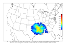
 
CIPS picking up on that system for next weekend. Definitely bears watching, but will take some time before we can get a better handle on what we're looking at. Still want to see significantly more model consistency before getting too concerned. Those kinematics off the more impressive runs are quite something, though.
1762745035943.png
 
Back
Top