May have something before the 21st. "Possible severe" can change quickly in November in the South. From this morning's SPC discussion...
..DISCUSSION...
Modified return flow will slowly build across the western Gulf mid
to late week, with a maritime tropical airmass probably reaching
parts of the TX Gulf Coast next weekend. As mentioned by WPC's EPD,
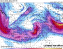
run-to-run model variability remains high with a large amount of
spread in the potential evolution of a broad upper trough
approaching the West Coast on D5/Thursday. This is well illustrated
by the change in SPC-CSU GEFS-ML probabilistic guidance over the
past 24 hours for D7/Saturday -- from a mesoscale 5% area in the
Mid-MS Valley in yesterday's D8 to a full-latitude 5% from the Rio
Grande to the Great Lakes, along with broad 15% and 30% highlights
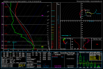
from parts of TX/LA to the Mid-MS Valley. While its parent 00Z GFS
appears conducive to severe, over what would likely be a subset of
these large highlights, this latest run lacks any semblance of
continuity. In addition, other models, such as the EC-AIFS suggest a
closed, cutoff low may just be in the process of moving onshore on
D7/Saturday, compared to the progressive, full-latitude trough over
the Great Plains in this GFS run. For this forecast, will upgrade to
Predictability Too Low for D7/Saturday and extend into D8/Sunday for
indications of possible severe, probably focused in the
South-Central States, within a low predictability pattern.