• Welcome to TalkWeather!
    We see you lurking around TalkWeather! Take the extra step and join us today to view attachments, see less ads and maybe even join the discussion.
    CLICK TO JOIN TALKWEATHER

Severe Weather 2025

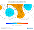
Modelling definitely sniffing out a possible threat for Friday. SPC also mentions it. Nothing crazy, but worth keeping an eye on. Mid-month could also be something, but it's way out there for now.

View attachment 48440View attachment 48441View attachment 48442View attachment 48443
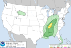
Slight risk now issued by SPC.
Day 3 Convective Outlook
NWS Storm Prediction Center Norman OK
0156 AM CST Wed Nov 05 2025

Valid 071200Z - 081200Z

...THERE IS A SLIGHT RISK OF SEVERE THUNDERSTORMS IN THE TN
VALLEY...

...SUMMARY...
Isolated to scattered severe thunderstorms are possible, mainly
Friday afternoon to evening, from parts of the Deep South to the
Ohio Valley.

...Synopsis...
A broad mid/upper trough, consisting of several embedded shortwave
impulses, will be maintained across the Northwest to the East on
Friday. Primary feature of interest will be the southernmost
shortwave impulse, progressing east across the Lower MO and OH
Valleys. At the surface, a cyclone over the northern Great Lakes
will move into QC. An attendant cold front will trail southwestward,
impinging on the Lower Great Lakes to Mid-South by late afternoon.

...Deep South to OH Valley...
Modified moisture return from the south-central Gulf should yield a
plume of moderate buoyancy over the Lower MS Valley by Friday
afternoon, with progressively weaker buoyancy extending northeast
ahead of the aforementioned cold front. Elevated convection may be
ongoing at 12Z Friday in parts of the Midwest within the low-level
warm conveyor. This activity will probably persist through the day
amid pronounced mid-level height falls. Whether this can become
surface based into the OH Valley vicinity, along the periphery of
the aforementioned buoyancy plume, is uncertain. Despite potentially
meager instability at most, expected fast low to mid-level flow will
be sufficient to warrant low severe probabilities.

Farther south, more probable severe-storm development appears to be
centered from south-central KY across the TN Valley. This corridor
should have a better opportunity for weak to modest destabilization,
where strong deep-layer shear and hodographs would favor supercells.
Consensus of non-NAM guidance is insistent on late afternoon to
early evening convective development along/ahead of this portion of
the front, which appears sufficient to warrant a level 2-SLGT risk
highlight. How intense and widespread the severe threat may become
will largely depend on the degree of destabilization early.

Subsiding large-scale ascent from southwest to northeast on Friday
night casts low confidence in the longevity of lingering severe.

..Grams.. 11/05/2025
1762345611003.png
 
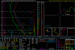
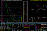
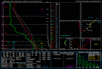
Environment Saturday evening near Dallas, Georgia off the NAM. A little contaminated but still represents the atmosphere well enough. Not half-bad and moisture is there. Seems questionable how much convection actually fires.

Edit: added additional sounding from near Atlanta proper.
1000004076.png1000004077.png
 
Last edited:
Environment Saturday evening near Dallas, Georgia off the NAM. A little contaminated but still represents the atmosphere well enough. Not half-bad and moisture is there. Seems questionable how much convection actually fires.

Edit: added additional sounding from near Atlanta proper.
View attachment 48445View attachment 48446
I'd say stuff easily fires given there's no real limit in the thermodynamics. A good rule of thumb for me is if you see a dry air slot around the same height as the LFC, that typically means that there is questions to storms firing. Depends how strong that dry slot is though in order for some impact to take place but it has worked plenty of times with conditional setups for me at least.
 
First Tornado Warning in November for NWS Portland OR CWA since November 21st, 2024. Prior to 2024, You have to go all the way back November 23rd, 2014 to find the last tornado warning in November.
 
Euro is looking spiffy for severe weather uptick going into Thanksgiving. If you want to see severe weather/tornado potential, there's your pattern. Trough in West, Ridge in East. Clash in between.
 

Attachments

  • 20251106015520-11d65a7b966b32d1ab6b7230dc56ca25ebe466cb.png
    20251106015520-11d65a7b966b32d1ab6b7230dc56ca25ebe466cb.png
    890.5 KB · Views: 0
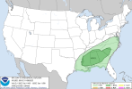
SPC has lower-end risks for Friday and Saturday across parts of the MSV, TNV and Gulf Coast.
SPC AC 060631

Day 2 Convective Outlook
NWS Storm Prediction Center Norman OK
1231 AM CST Thu Nov 06 2025

Valid 071200Z - 081200Z

...THERE IS A SLIGHT RISK OF SEVERE THUNDERSTORMS IN MIDDLE TN AND
SOUTH-CENTRAL KY...

...SUMMARY...
Isolated severe thunderstorms are possible, mainly Friday midday to
evening, from the central Gulf Coast to the Ohio Valley. A mesoscale
corridor of more concentrated severe hail potential is forecast
across Middle Tennessee and south-central Kentucky.

...Synopsis...
An expansive mid/upper trough will dominate the Northwest to the
central and eventually eastern CONUS on Friday, with several
embedded shortwave impulses. One impulse with an attendant mid-level
jetlet will progress from the Lower MO Valley to the central
Appalachians. The trailing portion of a cold front, attendant to a
southeast Canadian cyclone, should extend across the Lower Great
Lakes to Mid-South by early evening.

...Central Gulf Coast to the OH Valley...
Midday to mid-afternoon convection should generally be focused
across both the far northern and far southern extents of the
highlighted level 1-MRGL risk area.

The northern one across the OH Valley will be within the primary
low-level warm conveyor ahead of the aforementioned cold front, as
meager surface-based instability develops southeast of morning
elevated convection. Fast low to mid-level flow will be sufficient
for mainly localized damaging winds as low-topped clusters push east
towards the central Appalachians.

The southern one will be across the central Gulf Coast region where
an uncapped boundary layer in conjunction with weak mid-level height
falls/low-level warm theta-e advection should support isolated storm
coverage. While south of the 50+ kt mid-level westerlies over the
Mid-South/TN Valley, a couple supercells are possible.

Towards late afternoon and early evening, storm coverage may
increase southwestward from the OH Valley into the TN Valley. MLCAPE
will likely remain weak with rich low-level moisture remaining
confined to the southern Lower MS Valley. Still, strong deep-layer
shear and favorable hodograph elongation will yield supercell wind
profiles. Guidance does differ with the degree of storm coverage,
but enough signal exists for initial storms capable of severe hail
before potential clustering. Subsiding large-scale ascent and the
lack of greater instability should yield diminishing severe
potential Friday night in the Deep South.

..Grams.. 11/06/2025

CLICK TO GET WUUS02 PTSDY2 PRODUCT
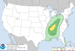
SPC AC 060818

Day 3 Convective Outlook
NWS Storm Prediction Center Norman OK
0218 AM CST Thu Nov 06 2025

Valid 081200Z - 091200Z

...THERE IS A MARGINAL RISK OF SEVERE THUNDERSTORMS IN THE
SOUTHEAST...

...SUMMARY...
Isolated severe thunderstorms are possible, mainly on Saturday
evening/night, across parts of the Southeast.

...Synopsis...
As one shortwave impulse moves offshore of the Mid-Atlantic and
Northeast early, a vigorous shortwave impulse will dig from the
Northern Great Plains into the Mid-MS Valley and Midwest. This will
support greater amplification of an expansive upper trough east of
the Rockies with a ridge building across the West. Cyclogenesis
should occur across the Lower MO Valley, tracking east into the OH
vicinity by 12Z Sunday.

...Southeast...
Forcing for ascent appears nebulous during the day Saturday in the
wake of the aforementioned trough passage along the coastal
Mid-Atlantic, and a remnant zonal mid-level flow regime across the
Southeast. The prior D2 cold front should stall and undergo a period
of frontolysis. Remnant outflow boundaries from overnight/Saturday
morning convection may aid in isolated convection during the
afternoon, with perhaps a few strong storms in parts of the interior
Deep South.

By evening into Saturday night, mid-level height falls will increase
downstream of the amplifying central states trough, and the residual
surface front should accelerate eastward from the Lower MS to TN
Valleys. Strengthening flow fields will be most prominent in the
mid-levels, largely relegated to overnight. The 00Z GFS appears to
be an outlier with a lack of appreciable convection, perhaps related
to depictions of weak lapse rates and low RH in the mid-levels. The
rest of guidance consensus indicates increasing nocturnal
development along the aforementioned cold front and downstream wedge
front near the southern Appalachians. Both regimes appear supportive
of a low-probability severe highlight.

..Grams.. 11/06/2025
1762434658331.png1762434723400.png
 
Well, aside from today in the US, portions of southern Brazil/Paraguay experienced (and still are) a very dangerous severe weather setup. This sounding from the GDPS is the best depiction i could get of the environment kinematically and safe to say this is absolutely not a setup you see often. Due to being in the southern hemisphere, hodographs will be typically opposite. Composite parameters are wonked off due to this feature however this is just very impressive.

Nearly 500 0-1km SRH combined with very impressive spring thermodynamics. Violent tornadoes would be easily capable of dropping with any favorable mesoscale interaction, and combined with a discrete storm mode. This is just wow
 

Attachments

  • gdps_2025110712_000_-25.95--57.0.png
    gdps_2025110712_000_-25.95--57.0.png
    240.3 KB · Views: 0
March 2-3, 2020 taught me to never count out a small slight risk with a 5% in middle TN.
That day definitely came to mind when seeing the 5% today, just in terms of similarity. Don't think something like that is in question today thankfully but we're definitely leaning on a interesting scenario if this storm matures going into Nashville with a tor risk (and possibly strong given the 100-130 in the MCD)
 
Well, aside from today in the US, portions of southern Brazil/Paraguay experienced (and still are) a very dangerous severe weather setup. This sounding from the GDPS is the best depiction i could get of the environment kinematically and safe to say this is absolutely not a setup you see often. Due to being in the southern hemisphere, hodographs will be typically opposite. Composite parameters are wonked off due to this feature however this is just very impressive.

Nearly 500 0-1km SRH combined with very impressive spring thermodynamics. Violent tornadoes would be easily capable of dropping with any favorable mesoscale interaction, and combined with a discrete storm mode. This is just wow
Just heard there was a very large tornado in Brazil.
 
Back
Top