
Navigation
Install the app
How to install the app on iOS
Follow along with the video below to see how to install our site as a web app on your home screen.
Note: This feature may not be available in some browsers.
More options
-
Welcome to TalkWeather! We see you lurking around TalkWeather! Take the extra step and join us today to view attachments, see less ads and maybe even join the discussion. CLICK TO JOIN TALKWEATHER
You are using an out of date browser. It may not display this or other websites correctly.
You should upgrade or use an alternative browser.
You should upgrade or use an alternative browser.
Severe Weather 2025
- Thread starter KevinH
- Start date
Kds86z
Member
WeathermanLeprechaun
Member
WeathermanLeprechaun
Member
Kds86z
Member
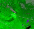
My area .A few tornadoes perhaps possible now in the mid-atlantic tomorrow. Mid level lapsw rates raise questions about storms sustaining but otherwise, conditional threat. We will see
WeathermanLeprechaun
Member
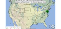
More specifically towards the Washington DC vicinity. A few tornadoes remain possible thru the 15z-18z period. Wouldn't be TOO surprised if SPC go 5% but not surprised if they don'tMy area .
WeathermanLeprechaun
Member
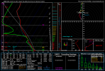
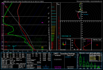
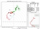
The conditional few tornadoes risk appears to have trended the good way. Morning convection is currently zapping up instability in the vicinity which was the best scenario. Admittedly we're rather lucky that instability was zapped. These shear profiles are rather impressive. If we got up to around 800-1k MLCAPE, very easily a strong tornado or two would've been possible.
Attachments
Kds86z
Member
The conditional few tornadoes risk appears to have trended the good way. Morning convection is currently zapping up instability in the vicinity which was the best scenario. Admittedly we're rather lucky that instability was zapped. These shear profiles are rather impressive. If we got up to around 800-1k MLCAPE, very easily a strong tornado or two would've been possible.
Attachments
Looking at latest forecast model runs (18z GFS, 12z Euro, and 12z Canadian), it looks like we might get back into the severe weather potential by late next week into next weekend.
WeathermanLeprechaun
Member
In agreement that the pattern may be busy. Strong low level shear meeting with instability a few times on some of those runs, but we will see if the trends continuous
I'm thinking about getting the RadarOmega Radar Sweep add on
akt1985
Member
Is Sunday 11/9 looking stormy for the Deep South? I’m returning from Florida that day.
- Thread starter
- #7,433
KevinH
Member
Came here to look for THESE kind of comments lolLooking at latest forecast model runs (18z GFS, 12z Euro, and 12z Canadian), it looks like we might get back into the severe weather potential by late next week into next weekend.
@Clancy you feel like chiming in at all about November? Ha
Agree with @JPWX. GFS shows a storm system for late next week into the weekend, but nothing that immediately appears overly-impressive. Likewise, ensembles show some possible disturbances moving through during that time frame, but it's not particularly eye-popping. This time of year, setups seem to be either immediately obvious due to kinematic profiles well into the medium range or rather hard to sniff out until a few days before.Came here to look for THESE kind of comments lol
@Clancy you feel like chiming in at all about November? Ha
slenker
Member
With how active the troughing has been over the east in the past two weeks, the moisture return for these upcoming systems is going to be rather unimpressive I imagine. Parts of the Gulf of Mexico's coastline aren't even managing dews in the 40s right now. It isn't the dead of winter yet, though, so I'm guessing it isn't going to be as challenging for said dewpoints to return to normal given enough time to do so.
Kds86z
Member
- Moderator
- #7,437
...Saturday/Day 7 and Sunday/Day 8...
On Saturday, a large-scale mid-level trough is forecast to quickly
take shape over the central U.S. Ahead of the trough, low-level
moisture is forecast to return northward into the Ark-La-Tex and mid
Mississippi Valley, where thunderstorms will be possible Saturday
afternoon. Convective coverage is forecast to expand southeastward
into the Ohio and Tennessee Valley Saturday night. Model forecasts
suggest that moderate instability and strong deep-layer shear will
be in place, which would support a severe threat from Saturday
afternoon and evening. Concerning the potential for a severe weather
event, uncertainty is substantial. Some solutions suggest that the
favorable environment for severe will remain spatially focused into
a small area, and that a front could undercut the convection. For
this reason, will keep the forecast at "predictability too low".
On Sunday, the system is forecast to move eastward across the lower
to mid Mississippi Valley. Ahead of the trough, an isolated severe
threat will be possible across parts of the Southeast and southern
Atlantic Seaboard. However, uncertainty concerning the potential for
severe storms is considerable at this range.
WeathermanLeprechaun
Member
RFD66
Member
Its out there a bit yes, but next weekend could be a deal.


Modelling definitely sniffing out a possible threat for Friday. SPC also mentions it. Nothing crazy, but worth keeping an eye on. Mid-month could also be something, but it's way out there for now.


...DISCUSSION...
...D4/Friday...
An area-of-interest, sufficient for a Predictability Too Low
highlight, appears centered on the OH Valley to Deep South. A
large-scale mid/upper trough should consist of several embedded
shortwave impulses progressing east from Hudson Bay through the
central to eastern CONUS. Primary surface cyclone is expected to
shift from the Upper Great Lakes into QC, with a trailing cold front
to its southwest undergoing frontolysis in the TN Valley/Deep South
by Friday night. Modified moisture return from the southern Gulf may
support moderate buoyancy over the Lower MS Valley, with a plume of
weak buoyancy extending into the OH/TN Valleys ahead of the front. A
belt of strong mid-level westerlies will yield favorable deep-layer
shear for organized severe potential. Latest GEFS-based SPC/NSSL ML
probs have trended upward with severe indications, more aggressive
than yesterday's available NCAR ECENS-based guidance. Overall setup
may tend to favor a more mesoscale-driven 15% area given uncertainty
on timing of convective development along the southwest extent of
the weakening front and the degree of destabilization where ascent
is stronger to the northeast.