SPC AC 060631
Day 2 Convective Outlook
NWS Storm Prediction Center Norman OK
1231 AM CST Thu Nov 06 2025
Valid 071200Z - 081200Z
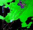
...THERE IS A SLIGHT RISK OF SEVERE THUNDERSTORMS IN MIDDLE TN AND
SOUTH-CENTRAL KY...
...SUMMARY...
Isolated severe thunderstorms are possible, mainly Friday midday to
evening, from the central Gulf Coast to the Ohio Valley. A mesoscale
corridor of more concentrated severe hail potential is forecast
across Middle Tennessee and south-central Kentucky.
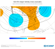
...Synopsis...
An expansive mid/upper trough will dominate the Northwest to the
central and eventually eastern CONUS on Friday, with several
embedded shortwave impulses. One impulse with an attendant mid-level
jetlet will progress from the Lower MO Valley to the central
Appalachians. The trailing portion of a cold front, attendant to a
southeast Canadian cyclone, should extend across the Lower Great
Lakes to Mid-South by early evening.
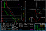
...Central Gulf Coast to the OH Valley...
Midday to mid-afternoon convection should generally be focused
across both the far northern and far southern extents of the
highlighted level 1-MRGL risk area.
The northern one across the OH Valley will be within the primary
low-level warm conveyor ahead of the aforementioned cold front, as
meager surface-based instability develops southeast of morning
elevated convection. Fast low to mid-level flow will be sufficient
for mainly localized damaging winds as low-topped clusters push east
towards the central Appalachians.
The southern one will be across the central Gulf Coast region where
an uncapped boundary layer in conjunction with weak mid-level height
falls/low-level warm theta-e advection should support isolated storm
coverage. While south of the 50+ kt mid-level westerlies over the
Mid-South/TN Valley, a couple supercells are possible.
Towards late afternoon and early evening, storm coverage may
increase southwestward from the OH Valley into the TN Valley. MLCAPE
will likely remain weak with rich low-level moisture remaining
confined to the southern Lower MS Valley. Still, strong deep-layer
shear and favorable hodograph elongation will yield supercell wind
profiles. Guidance does differ with the degree of storm coverage,
but enough signal exists for initial storms capable of severe hail
before potential clustering. Subsiding large-scale ascent and the
lack of greater instability should yield diminishing severe
potential Friday night in the Deep South.
..Grams.. 11/06/2025
CLICK TO GET
WUUS02 PTSDY2 PRODUCT