KakashiHatake2000
Member
Does that mean we can drill down the the center of the earth with an ef6 ef7 and so on and so forth in a field
Follow along with the video below to see how to install our site as a web app on your home screen.
Note: This feature may not be available in some browsers.

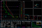
Well, first action in a while. Guess we will see where this one goes.View attachment 47246
Friday night, low-level moisture advection is forecast to markedly
increase as surface dewpoints in the lower to mid 60s F overspread
the Ark-La-Tex, Ozarks and mid Mississippi Valley. Moderate
instability is expected to develop early in the day on Saturday
across parts of the moist sector, where moderate to strong
deep-layer shear will be in place. Thunderstorms that form along and
near the axis of strongest instability should obtain a severe
threat. Supercells with severe wind gusts, hail and tornado
potential will be possible. The magnitude of the severe threat will
be greatest in areas that remain unaffected by morning thunderstorm
activity. The severe threat should spread eastward into the lower to
mid Mississippi Valley Saturday evening and into the overnight
period. Although lingering uncertainties exist, confidence in the
model solutions is great enough to add a 15 percent area over parts
of Ark-La-Tex, Ozarks and lower to mid Mississippi Valley.
...Sunday/Day 7 and Monday/Day 8...
The mid-level trough is forecast to move eastward across the lower
to mid Mississippi Valley on Sunday and to the mid Atlantic Seaboard
on Monday. Thunderstorms will be ongoing Sunday morning, ahead of a
cold front moving through the Ohio and Tennessee Valleys. New
convective development is expected during the day on Sunday ahead of
the front as surface temperatures warm. Thunderstorm development
should also occur on Monday ahead of the front. However, instability
is forecast to remain relatively weak across much of the moist
sector on Sunday and Monday, suggesting the severe threat in most
areas will remain relatively isolated.
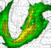
Broyles with T word this far out.View attachment 47246
Friday night, low-level moisture advection is forecast to markedly
increase as surface dewpoints in the lower to mid 60s F overspread
the Ark-La-Tex, Ozarks and mid Mississippi Valley. Moderate
instability is expected to develop early in the day on Saturday
across parts of the moist sector, where moderate to strong
deep-layer shear will be in place. Thunderstorms that form along and
near the axis of strongest instability should obtain a severe
threat. Supercells with severe wind gusts, hail and tornado
potential will be possible. The magnitude of the severe threat will
be greatest in areas that remain unaffected by morning thunderstorm
activity. The severe threat should spread eastward into the lower to
mid Mississippi Valley Saturday evening and into the overnight
period. Although lingering uncertainties exist, confidence in the
model solutions is great enough to add a 15 percent area over parts
of Ark-La-Tex, Ozarks and lower to mid Mississippi Valley.
...Sunday/Day 7 and Monday/Day 8...
The mid-level trough is forecast to move eastward across the lower
to mid Mississippi Valley on Sunday and to the mid Atlantic Seaboard
on Monday. Thunderstorms will be ongoing Sunday morning, ahead of a
cold front moving through the Ohio and Tennessee Valleys. New
convective development is expected during the day on Sunday ahead of
the front as surface temperatures warm. Thunderstorm development
should also occur on Monday ahead of the front. However, instability
is forecast to remain relatively weak across much of the moist
sector on Sunday and Monday, suggesting the severe threat in most
areas will remain relatively isolated.
Although people weren't too fond of Broyles' rather bullish tendencies on outlooks, i actually think that when he goes with this type of wording, it sparks more attention then other forecasters do so. after what we've seen this year, everything the man discusses I've took into close consideration following severe threats.View attachment 47246
Friday night, low-level moisture advection is forecast to markedly
increase as surface dewpoints in the lower to mid 60s F overspread
the Ark-La-Tex, Ozarks and mid Mississippi Valley. Moderate
instability is expected to develop early in the day on Saturday
across parts of the moist sector, where moderate to strong
deep-layer shear will be in place. Thunderstorms that form along and
near the axis of strongest instability should obtain a severe
threat. Supercells with severe wind gusts, hail and tornado
potential will be possible. The magnitude of the severe threat will
be greatest in areas that remain unaffected by morning thunderstorm
activity. The severe threat should spread eastward into the lower to
mid Mississippi Valley Saturday evening and into the overnight
period. Although lingering uncertainties exist, confidence in the
model solutions is great enough to add a 15 percent area over parts
of Ark-La-Tex, Ozarks and lower to mid Mississippi Valley.
...Sunday/Day 7 and Monday/Day 8...
The mid-level trough is forecast to move eastward across the lower
to mid Mississippi Valley on Sunday and to the mid Atlantic Seaboard
on Monday. Thunderstorms will be ongoing Sunday morning, ahead of a
cold front moving through the Ohio and Tennessee Valleys. New
convective development is expected during the day on Sunday ahead of
the front as surface temperatures warm. Thunderstorm development
should also occur on Monday ahead of the front. However, instability
is forecast to remain relatively weak across much of the moist
sector on Sunday and Monday, suggesting the severe threat in most
areas will remain relatively isolated.
100% @WeathermanLeprechaunAlthough people weren't too fond of Broyles' rather bullish tendencies on outlooks, i actually think that when he goes with this type of wording, it sparks more attention then other forecasters do so. after what we've seen this year, everything the man discusses I've took into close consideration following severe threats.
Broyles loves going in depth on tornado type days and it's pretty evident haha
Yeah, no point going and setting a "first impression" for the setup when we still have plenty of things to uncover (The extent of how morning convection affects the day, if airmass recovery will be important enough) that's all for soon, and not now.Saturday (Day 6) looks to have appreciable moisture return for a fall severe wx setup. Sun angles are still high enough where daytime heating should be of aid, too. The big question will be how does the trajectory of jet stream change over the week and do models lock on a consistent idea by Thursday or Friday.
Yeah I chomping at the bit for severe kick back in. Ready for a big tornado chase close byThis area cannot catch a break this year..
Be safe…Yeah I chomping at the bit for severe kick back in. Ready for a big tornado chase close by