AJS
Member
What’re the models showing right now? I haven’t had time to get a good look at them.Starting to get interested Saturday and Sunday mid south area …..
Follow along with the video below to see how to install our site as a web app on your home screen.
Note: This feature may not be available in some browsers.
What’re the models showing right now? I haven’t had time to get a good look at them.Starting to get interested Saturday and Sunday mid south area …..
Dunno what the track record is for this model, but I came across this in my FB feed.
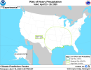
Thru May 10th is exactly what I stated in my Patreon post last night.Too early for specifics beyond Thursday-Friday, but 00Z CFS/GFS are quite active at least through the middle of next week, then the former suggests more systems through at least May 10th. All the days combined could affect a large swath including the Plains, Midwest, Ohio Valley and the South.
Thru May 10th is exactly what I stated in my Patreon post last night.
Consistent patterns on model runs are definitely something worth paying attention to, as even if they may show differences in detail and may not verify verbatim, the general trends would still suggest that there's something going on.Pretty consistent signal though
It does seem like at least some areas go through repeated cycles of low activity followed by high activity followed by low activity, etc. I admittedly haven't dug too deeply on that subject (at least not recently, anyway), but I do recall that, for example, while the Great Plains were suffering from the Dust Bowl from the 1930s, most tornado activity shifted eastward (most notably hitting the Southeastern US quite hard with at least several notorious tornadoes and tornado outbreaks).It really is surprising how Alabama has (besides the 15th but Mississippi got the worst) avoided a very high caliber outbreak the past 4 years. Seems like every region has had a big outbreak in that time frame. ArkLaMiss, Western KY and TN, the Ohio valley, the plains last year. Even the northern plains got in on the action on 4/26 last year.
Alabama had a pretty quiet period in the mid 2000s before Super Tuesday didn’t they?
Euro definitely looks sorta promising for Sunday in the mid south area it looks like.Starting to get interested Saturday and Sunday mid south area …..
Yeah Little Rock klzk already mentioned discrete supper cellular activity…. I will start digging intoEuro definitely looks sorta promising for Sunday in the mid south area it looks like.
LZK has really gained my trust. So far, they’ve been spot on with their forecasting on their discussions so the fact they are already mentioning discrete super cellular activity has my attention.Yeah Little Rock klzk already mentioned discrete supper cellular activity…. I will start digging into
The models starting later today


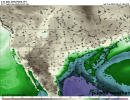
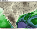
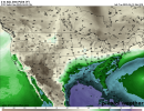
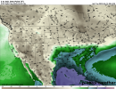
That's quite the look for day 6 and analogs for day 6 on cips.Definitely looks like the Mid-South might be under the gun yet again come weekend. SPC has a D6 outline for this threat on Sunday. Models still a little shaky; a compact feature like this would probably be the most potent solution. The remainder of the month also looks to be active across much of the South and Plains.
View attachment 39774View attachment 39775View attachment 39776View attachment 39777
View attachment 39778
Looks like rest will be over with ….That's quite the look for day 6 and analogs for day 6 on cips.
Always an oddball. GFS has not been very good this year.Euro for the win. GFS is just being the oddball as always. However, I will say that the dewpoints on the GFS are very favorable for severe storms. All 4 GFS runs today.
Uh does everyone else see the massive visual change to this site UI?

I actually kinda like this look better for some reason. Idk why.Uh does everyone else see the massive visual change to this site UI?