
There is some operational use in the CFS ensemble sets that are listed as the "weeklies" and the "monthlies" for long-range seasonal and sub-seasonal forecasting... but the operational deterministic CFS, you're better off blindfolded drunken donkey to tell you what's going to happen. Operational runs of the GFS and Euro are back and forth on whether there is troughing in the west that would allow us to trend a bit warmer or flat troughing in the east just north of the subtropical ridge that would allow cool shots to continue to come down... but the ensembles are pretty consistent on the idea of any troughing hanging closer to the eastern half of the continent instead of the western half through the early part of February. This Sunday/Monday wet system across the Southeast initially looked like it may have an inland warm sector of 60+ dewpoints when it was 300 hrs out. Now, we're actually watching to see if it may have a little sleet or freezing rain for a short-time on the front side of it Saturday night into Sunday morning across parts of the TN Valley. These long-range warmer looks aren't holding as systems get closer. Any sustained pattern change keeps playing the "kick the can down the road" game, and that's a classic sign that one isn't actually coming anytime really soon.What is the difference between how the CFS vs. the other models work? It goes out way further and is notably weaker on resolution so I'm guessing it's a much simpler model.
To me, the CFS seems to be showing some sort of pattern flip favorable for severe weather in February, and the ECMWF is showing something (marginally) congruent to that, but I'm guessing it's way too far out to draw any conclusions. Some of the warm sectors I am seeing are really quite something when it gets to about 180+ hours out and they are not getting fully shunted out far into the Gulf before they bleed back into the US - it seems like the consensus here is the opposite of that.
Navigation
Install the app
How to install the app on iOS
Follow along with the video below to see how to install our site as a web app on your home screen.
Note: This feature may not be available in some browsers.
More options
-
Welcome to TalkWeather! We see you lurking around TalkWeather! Take the extra step and join us today to view attachments, see less ads and maybe even join the discussion. CLICK TO JOIN TALKWEATHER
You are using an out of date browser. It may not display this or other websites correctly.
You should upgrade or use an alternative browser.
You should upgrade or use an alternative browser.
Severe Weather 2025
- Thread starter KevinH
- Start date
I've also heard it be described as (among other things) the "GooFuS".GFS stands for Goofy Forecast System in my book

tennessee storm chaser
Member
- Messages
- 1,877
- Reaction score
- 4,283
- Location
- jackson tennessee
- Special Affiliations
- SKYWARN® Volunteer
So basically this La Niña think will peak in the heart of spring . Is it fair Fred to think Dixie and mid south will have a better than average chance seeing at least one large scale severe wx outbreak this spring season ?At least as of current writing time, there's nothing organized/widespread on the horizon in the immediate foreseeable future. The systems that were initially looking like potentially more of a convective situation have already begun leaning more toward a direction of either being overrunning rain events or potentially even more winter threats for some portions of the Southeast. That's not too surprising given that, in a large scale sense, it doesn't look like we're going to significantly shake this pattern of waves leading to eastern troughing and cooler than normal conditions anytime soon, outside of short reprieves. As a matter of fact, ensembles and the "weeklies" datasets have shown big eastern troughing and potential Southeast wintry threats going deep into late February.
Outside of "nickel & dime" potential events, I don't see severe weather wholesale waking up anytime really soon. Instead of a La Nina season where we max our Nina-driven severe activity early in the year and then it shifts away before spring even starts, I think this is acting like other La Nina years we've seen in years past (especially first-year La Ninas) where we are delaying the wholesale start of things until spring. I wouldn't be shocked if we see an April peak in Dixie this year, something we haven't seen in a while.
Oh, and yes, we are officially in "La Nina conditions" as declared by CPC. That snuck in while we were watching the winter storm across the Deep South back last week. The colder waters have been long-term situated in ENSO Regions 3.4 and 4 though, making this a west-based La Nina. For those of you that have read up on the Trans-Nino Index at some point over the past several years and how a positive phase of that thing can affect tornado frequency and intensity, my post has probably already made your ears perk up.
We'll see what happens...
No way to tell that at this point.So basically this La Niña think will peak in the heart of spring . Is it fair Fred to think Dixie and mid south will have a better than average chance seeing at least one large scale severe wx outbreak this spring season ?
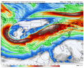
Starting to see more consistent signals that there may possibly be a window open for a severe weather threat in early February before we do a potential switch back to cold near or just before mid month. Operationals are hinting but are inconsistent. There is good general operational support in the pattern with favorably placed bookend ridges in the EPAC and WATL and a near CONUS-wide longwave low amplitude trough in between them, and a channel jet type setup riding through that longwave trough. There's no singular system to lock onto yet, although some are being modeled in the operational models from time to time, such as the 12Z GFS today around Feb 6th. I would watch especially between maybe the 3rd and the 7th, but that little window may float around by a couple of days, and it may need to be extended for a few days out in time if the pattern tries to linger for more than one system. It may also not necessarily be a big or widespread threat, depending on thermos, but I do think there may be a window open.
Looking at a specific operational model run and what it shows at face value at this point is highly unimportant... but the basic pattern is there.
Looking at a specific operational model run and what it shows at face value at this point is highly unimportant... but the basic pattern is there.
ashtonlemleywx
Member


Now, that I've seen a non AI model latching onto the potential for a couple threats, I'm giving this more a look into. 12z GFS today suggests 2 threats. One around next weekend and the other around Feb 3rd thru roughly 6th timeframe.
Attachments
ashtonlemleywx
Member
Yea that longwave that comes through after the preceding cutoff low has my attentionNow, that I've seen a non AI model latching onto the potential for a couple threats, I'm giving this more a look into. 12z GFS today suggests 2 threats. One around next weekend and the other around Feb 3rd thru roughly 6th timeframe.
tennessee storm chaser
Member
- Messages
- 1,877
- Reaction score
- 4,283
- Location
- jackson tennessee
- Special Affiliations
- SKYWARN® Volunteer
Just fixing speak on that myself lolYea that longwave that comes through after the preceding cutoff low has my attention
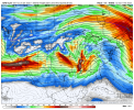
12z euro is a good look, wonder if substantial moisture can build in with that big ole bowling ball 
tennessee storm chaser
Member
- Messages
- 1,877
- Reaction score
- 4,283
- Location
- jackson tennessee
- Special Affiliations
- SKYWARN® Volunteer
My eyebrows are raised on tonight’s 0zggfs . Early February . Good thing still kind out there .
AJS
Member
Looking likely that a potent severe weather setup could come into place next week.
AJS
Member
Not liking the forecast for my area as well. Next week is supposed to be warmer than average than it normally is in January.
AJS
Member


Wednesday and Thursday.
slenker
Member
Really interested to see what the 12z ECMWF shows....
AJS
Member
I am still not perfect in analyzing severe weather maps and forecasting/predicting what could happen so I just wanted to ask, What day looks like the most concerning to yall?
Greatest risk day for your area looks to be Thursday. Though magnitude of threat overall remains uncertain.I am still not perfect in analyzing severe weather maps and forecasting/predicting what could happen so I just wanted to ask, What day looks like the most concerning to yall?
AJS
Member

Slight risk has been issued for Wednesday.
Cyclonic Paracosm
Member
yurp, hail and wind seems to be the main threat per spc
Austin Dawg
Member
Just watching.
Tonight AUS/SAN discussions.
.LONG TERM...
(Wednesday through Monday)
Issued at 224 PM CST Mon Jan 27 2025
Key Messages:
- A frontal system will bring a chance for showers and thunderstorms
Wednesday and Thursday
- A few stronger storms are possible Wednesday night and Thursday
- Rainfall totals have trended down
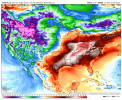
Temperatures will warm for the middle of the week. High temperatures
will reach the upper 60s and 70s by Wednesday. Models are showing an
upper level low moving across the southwest US and into the central
plains Wednesday into Friday. This feature will bring a Pacific front
through our CWA. Ahead of this system winds from the southeast will
bring moist air with unusually high PW values by Wednesday. Models
have trended toward a more northward path of the upper low and a
faster frontal passage. When the front moves into the moist air
there will be a chance for showers and thunderstorms across the
entire area. There will be a modest amount of CAPE with good vertical
wind shear meaning a chance for some strong to severe thunderstorms.
Better ingredients for strong storms will be farther north than our
CWA and any strong storms will likely be across our northern
counties. Models have come in a little drier and chances for
excessive rainfall are going down. The best timing right now looks
like Wednesday night and Thursday morning. Showers may linger in
Friday morning and by Friday afternoon any rain should have moved
off to the east. Dry weather will continue into early next week.
Temperatures will be cool in the morning and warm in the afternoon
each day Saturday through Monday.
Tonight AUS/SAN discussions.
.LONG TERM...
(Wednesday through Monday)
Issued at 224 PM CST Mon Jan 27 2025
Key Messages:
- A frontal system will bring a chance for showers and thunderstorms
Wednesday and Thursday
- A few stronger storms are possible Wednesday night and Thursday
- Rainfall totals have trended down
Temperatures will warm for the middle of the week. High temperatures
will reach the upper 60s and 70s by Wednesday. Models are showing an
upper level low moving across the southwest US and into the central
plains Wednesday into Friday. This feature will bring a Pacific front
through our CWA. Ahead of this system winds from the southeast will
bring moist air with unusually high PW values by Wednesday. Models
have trended toward a more northward path of the upper low and a
faster frontal passage. When the front moves into the moist air
there will be a chance for showers and thunderstorms across the
entire area. There will be a modest amount of CAPE with good vertical
wind shear meaning a chance for some strong to severe thunderstorms.
Better ingredients for strong storms will be farther north than our
CWA and any strong storms will likely be across our northern
counties. Models have come in a little drier and chances for
excessive rainfall are going down. The best timing right now looks
like Wednesday night and Thursday morning. Showers may linger in
Friday morning and by Friday afternoon any rain should have moved
off to the east. Dry weather will continue into early next week.
Temperatures will be cool in the morning and warm in the afternoon
each day Saturday through Monday.