Latest Discussion: San Antonio/Austin:
Our attention then turns to the storm system advancing across the
Four Corners region. Pre-frontal shower activity will steadily
increase beneath the
capping inversion over central and eastern
portions of the region. Increasing lift and
upper level energy will
then help generate elevated
convection across the southern Edwards
Plateau and western Hill Country tonight. However as noted previously
MUCAPE values only range from 500 to 1000
J/kg, but plenty of deep
layer
shear and mid-level lapse rates ranging between 7 and 8
C/KM
could help to sustain stronger updrafts capable of small to
marginally severe sized
hail. When looking at the HREF
helicity
updraft ensemble min/max we do see that there is potential for some
stronger storms to root themselves but only if the
cap erodes which
could be a tall task. We do see a strengthening
LLJ overnight which
could help erode said
cap, however the question becomes will any
storms take advantage? or will it be more of a too little too late
situation as the window for
instability closes quite rapidly as most
guidance continues to suggest. Regarding
instability, it seems due to
the amount of dense
overcast conditions coupled with very dense
fog
across parts of the area has helped to mitigate
instability values.
This further suggests we may just see some stronger but not quite
severe storms overnight. Additionally once storms develop they look
to impact the
FWD CWA first and then gradually congeal into a north
south band that should eventually sweep across our
CWA starting from
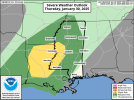
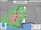
the Edwards Plateau region and making their way east. Due to the
aforementioned
helicity values and strong bulk layer
shear from
0-6km there is a conditional
tornado threat that does exist should
some storms take advantage of a decreasing
cap. Agree with the
SPC
tornado risk of 2% within 25 miles of a point for mainly the northern
half of our
CWA into the Hill Country and across the I-35 Corridor.
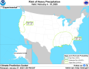
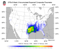
Locally heavy
rainfall will be possible as well with the strongest
thunderstorms, however this activity should be rather quick moving
which would limit flooding concerns. However, since storms are
expected to already be ongoing north of our
CWA there is a
possibility that the southern extent, particularly into the Hill
Country down towards the southern Edwards Plateau, could have some
training due to the slow backbuilding nature of the southern fringe
of this line of storms. This is noted in several
hi-res model
guidance as we move forward in time and get closer to initialization
for these storms. Expected rain amounts of 1 inch to 1.25 inches is
possible for the Hill Country and eastern parts of the southern
Edwards Plateau, with possibly higher amounts wherever training of
heavier thunderstorms occurs. Everyone else can expect a quarter to
one inch of much needed
rainfall. WPC has portions of the southern
Edwards Plateau, Hill Country, and northern I-35 corridor in a
marginal risk (level 1 of 4) for excessive
rainfall from late
tonight into early Thursday morning.
All
thunderstorm activity should be well past our area by 21Z
Thursday evening if not slightly sooner depending on the speed of
this
front. Once this
front moves through we should see
partly sunny
skies with temperatures in the low to mid 70s areawide.