KakashiHatake2000
Member
I just would like to know what everybody’s opinion on this with forecasting 9-10 days to three weeks in advance with the new nssl testing product tool
Last edited:
Follow along with the video below to see how to install our site as a web app on your home screen.
Note: This feature may not be available in some browsers.
I’m not familiar @KakashiHatake2000 with it but I hope someone has some insight.? I just would like to know what everybody’s opinion on this with forecasting 9-10 days to three weeks in advance with the new nssl testing product tool
Oh sorry I had to make a change in the link Facebook likes to show who shared the Facebook link so I did thatI’m not familiar @KakashiHatake2000
Oh ok cool.Oh sorry I had to make a change in the link Facebook likes to show who shared the Facebook link so I did that
YeahOh ok cool.
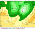
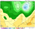
The SPC is beginning to hint at severe weather uptick potential near or beyond Day 8 (Friday/Saturday) of next week. This is getting within the timeframe that the 12z Canadian Ensemble had a severe weather threat on the September 29th run.
Further west, the ECMWF suite of guidance suggests an upper
shortwave trough may eject across the central Rockies into the
central Plains around Day 6 or 7/Wed or Thu, with some southerly
return flow bringing Gulf moisture northward ahead of this feature.
However, the GFS suite of guidance is delayed with this feature
until near/after Day 8/Fri. Thunderstorm could increase across parts
of the Plains late in the forecast period, but uncertainty/model
spread is quite large.
Not seeing a big temperature difference next weekend on current 10-day for me, but I suspect that will change. It's definitely that time of year where you start looking for a 20 degree or greater temp difference for severe storms.I was wondering out loud earlier if we had storms coming up. Looks like a strong cold front coming through next weekend based on estimated temps.


.jpg)
.jpg)