
Navigation
Install the app
How to install the app on iOS
Follow along with the video below to see how to install our site as a web app on your home screen.
Note: This feature may not be available in some browsers.
More options
-
Welcome to TalkWeather! We see you lurking around TalkWeather! Take the extra step and join us today to view attachments, see less ads and maybe even join the discussion. CLICK TO JOIN TALKWEATHER
You are using an out of date browser. It may not display this or other websites correctly.
You should upgrade or use an alternative browser.
You should upgrade or use an alternative browser.
Severe Weather 2025
- Thread starter KevinH
- Start date
Kds86z
Member
Not sure @OzonelayerAren't Mini Supercells usually more common in cold-core outbreaks?
Ozonelayer
Member

After some research (A quick google search and a quick visit to the NWS website), Mini Supercells mainly do occur in cold core setups. These can still produce strong-intense tornadoes (See July 16th of this year, where multiple mini supercells produced significant tornadoes across Wisconsin. One had horizontal vorticies aswell.)
Kds86z
Member
Cool @Ozonelayer , I wanna say tropical cyclone tornadoes are mini supercells tooView attachment 46610
After some research (A quick google search and a quick visit to the NWS website), Mini Supercells mainly do occur in cold core setups. These can still produce strong-intense tornadoes (See July 16th of this year, where multiple mini supercells produced significant tornadoes across Wisconsin. One had horizontal vorticies aswell.)
Kds86z
Member
Ozonelayer
Member
Cool @Ozonelayer , I wanna say tropical cyclone tornadoes are mini supercells too
Yeah, I believe a great example was Milton from last year? Mini-Supercells in the bands produced multiple EF-3s right?
Kds86z
Member
I gotta check if multiple ef3, thought only one .Yeah, I believe a great example was Milton from last year? Mini-Supercells in the bands produced multiple EF-3s right?
Kds86z
Member
which produced at least three EF3 tornadoes in Florida. The EF3 rating indicates estimated wind speeds between 136-160 mph. The deadliest of these was a long-tracked EF3 tornado in Fort Pierce, which caused six fatalities. This event was significant as it was the first time since 1995 that more than one EF3 tornado occurred during a single tropical cycloneI gotta check if multiple ef3, thought only one .
Ozonelayer
Member
Yeah, always thought Milton was a prolific tornado producer compared to other hurricanes.which produced at least three EF3 tornadoes in Florida. The EF3 rating indicates estimated wind speeds between 136-160 mph. The deadliest of these was a long-tracked EF3 tornado in Fort Pierce, which caused six fatalities. This event was significant as it was the first time since 1995 that more than one EF3 tornado occurred during a single tropical cyclone
Anyway, mini-supercells fascinate me for some reason. I do think mini cells and cold core outbreaks as a whole are kind of slept on as far as popularity and chasing goes.
Kds86z
Member
Yeah Milton Florida outbreak was historical, Florida’s biggest outbreak.Yeah, always thought Milton was a prolific tornado producer compared to other hurricanes.
Anyway, mini-supercells fascinate me for some reason. I do think mini cells and cold core outbreaks as a whole are kind of slept on as far as popularity and chasing goes.
Kds86z
Member
Wow..
Kds86z
Member
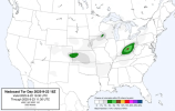
One interesting thing about tonight is that Nadocast nailed the tornado warnings in SW Ohio, while the SPC didn't have a 2% tornado risk anywhere close. It's not often you see that happen, so I wonder what was missed in this case.
Attachments
N0mz
Member
Feels like a significant downtrend in the 00z suite of models. Lower SRH and much less deep layer shear leading to a more linear mode
Kds86z
Member
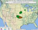
New day 1:
this is September right? Lol
AS THE SHORTWAVE TROUGH APPROACHES, ROBUST DESTABILIZATION IS
EXPECTED OVER MUCH OF THE WARM SECTOR OWING TO HEATING AMIDST 70S F
SURFACE DEWPOINTS. AFTERNOON MLCAPE OF 2000-3000 J/KG SHOULD SUPPORT
RAPID THUNDERSTORM DEVELOPMENT ALONG THE PER-FRONTAL SURFACE
TROUGH/WIND SHIFT AND NEAR THE EFFECTIVE BOUNDARY. SEMI-DISCRETE
SUPERCELLS ARE EXPECTED WITH A CONTINUED 30+ KT SOUTHWESTERLY
LOW-LEVEL JET HELPING TO EXPAND HODOGRAPHS. DAMAGING GUSTS AND SOME
HAIL (OCCASIONAL 2+ INCH) ARE POSSIBLE WITH INITIAL STORMS FROM
EASTERN OK INTO NORTHEAST TX WHERE LOW-LEVEL FLOW IS MORE VEERED AND
LAPSE RATES ARE STEEPER. TORNADO POTENTIAL (CONDITIONALLY
SIGNIFICANT) IS LIKELY TO BE MAXIMIZED NEAR THE EFFECTIVE TRIPLE
POINT AND MODIFYING OUTFLOW BOUNDARY FROM NORTHEASTERN OK INTO
WESTERN AR. HERE, BACKED LOW-LEVEL FLOW, ESRH OF 200-300 M2/S2 AND
THE POTENTIAL FOR HIGHER LOW-LEVEL BUOYANCY COULD SUPPORT LOCALLY
STRONGER LOW-LEVEL MESOCYCLONES. HIGHER TORNADO PROBABILITIES MAY BE
NEEDED AS CONFIDENCE IN FINAL BOUNDARY POSITIONING AND
DESTABILIZATION, POST MCS, BECOMES MORE CLEAR.
Ozonelayer
Member

Ok 13z HRRR, I see you.
joshoctober16
Member
was looking too messy earlier but now its starting to look severe again.

N0mz
Member
13z and 14z hrrr runs both have significant prefrontal cells in good environments at around 22z


N0mz
Member
15z also has prefrontals, albeit a little more messy. I do think its just HRRR struggling to resolve the super high resolution stuff.
Ozonelayer
Member
We think they'll pull the trigger on a 10% hatched?15z also has prefrontals, albeit a little more messy. I do think its just HRRR struggling to resolve the super high resolution stuff.View attachment 46622