Ozonelayer
Member
So what would be the ideal scenario for tomorrow, tornado-wise that is?Definitely #WaitAndSee at this point. Whatever happens today will greatly help resolve the forecast for tomorrow.
Follow along with the video below to see how to install our site as a web app on your home screen.
Note: This feature may not be available in some browsers.
So what would be the ideal scenario for tomorrow, tornado-wise that is?Definitely #WaitAndSee at this point. Whatever happens today will greatly help resolve the forecast for tomorrow.


where would that be joshoctober16 the spc does have a mcd out for maybe quote unquote cell up in wisconsin
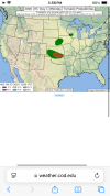
View attachment 46606Storm Prediction Center Mesoscale Discussion 2116
Severe weather, tornado, thunderstorm, fire weather, storm report, tornado watch, severe thunderstorm watch, mesoscale discussion, convective outlook products from the Storm Prediction Center.www.spc.noaa.gov
oh okay i see thank you cheeselandskies hope somebody got some nice shots of the supercell structureYes, that was the one. Had a pretty decent supercell structure there for a while as it moved right along the MS River, but appears to have moved off the boundary and weakened a bit; SVR warning dropped.
wowie holy moly
sameWow what a little Beauty I wasn’t expecting.