US_Highway15
Member
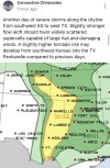
That's my question. Helicity/shear numbers have ticked up a tad in the past few model runs compared to the past 24 hours, but they still don't scream "tornado outbreak" numbers. That's part of why this setup is a bit complicated, and is why I view this as one of those setups so far that truly separate the amateur forecasters, to the professional ones.Same, if shear and helicity increase by any notable margin and we have confidence in the storm mode, then a significant day is what we could be looking at.
Heck I remember 2 days ago when I said "still a lot of questions to be answered before I call this a significant setup" but now, I genuinely only have 1 question. Will the helicity and shear increase? Because the CAPE is there, lapse rates look decent, supercell composite is consistantly in the 5-11 range, hodographs are well rounded, and moisture looks ok aswell. Helicity and shear are the only things that need to increase before I really start digging into this setup.
Last edited: