
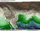
European model is more robust with Gulf moisture next weekend compared with the other 00z model runs, but all the other models have the 60s dewpoints swept into at least the Central Gulf by Saturday evening (March 24th). Plenty of time to watch this and for this to change of course, but this is a key thing to watch as we go into next week.One thing to consider when looking at the 3/25-3/27 time frame is the dewpoints in the Gulf leading up to the event. We'll have to keep an eye on the Mid level shortwave across the Southeast later this upcoming week as that may sweep the Gulf of the better moisture.
This system in the end of March will have to do a lot of work in a short amount of time to bring up the more robust moisture. I can post a comparison among the 00z models once the European model comes out.
Navigation
Install the app
How to install the app on iOS
Follow along with the video below to see how to install our site as a web app on your home screen.
Note: This feature may not be available in some browsers.
More options
-
Welcome to TalkWeather! We see you lurking around TalkWeather! Take the extra step and join us today to view attachments, see less ads and maybe even join the discussion. CLICK TO JOIN TALKWEATHER
You are using an out of date browser. It may not display this or other websites correctly.
You should upgrade or use an alternative browser.
You should upgrade or use an alternative browser.
Severe Weather 2024
- Thread starter KevinH
- Start date
SPC Day 4-8 Discussion:
"But it is not out of the
question that developments could support increasing organized severe
weather potential across parts of the Great Plains into Mississippi
Valley by late next weekend, if not earlier."
"But it is not out of the
question that developments could support increasing organized severe
weather potential across parts of the Great Plains into Mississippi
Valley by late next weekend, if not earlier."
akt1985
Member
March 27th is already a Red Letter Day in Alabama with the 30th anniversary of the Goshen Church Tornado Tragedy. I hope that day nothing happens in Alabama.
- Thread starter
- #945
KevinH
Member
What year?March 27th is already a Red Letter Day in Alabama with the 30th anniversary of the Goshen Church Tornado Tragedy. I hope that day nothing happens in Alabama.
- Thread starter
- #946
KevinH
Member
00z Canadian and Euro

CheeselandSkies
Member
What year?
Palm Sunday, 1994.

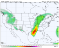
Well thankfully it's the GFS so I'm not overly concerned about this threat just going away.Overall downtrend in moisture return on the GFS.
View attachment 24399
Certainly not, and the Euro was still fairly robust (though only just coming into range on the publicly-available runs), but definitely a trend to keep an eye on.Well thankfully it's the GFS so I'm not overly concerned about this threat just going away.
NWS Jackson, MS Afternoon Discussion:
A weak positively tilted
shortwave trough crossing the area will increase rain chances some
for Wed night/Thursday/Thu night, but significant impacts are not
expected from this system. Mostly quiet weather should resume for
next weekend, but as mentioned this morning, a more significant
system could eventually bring stormy weather as we go beyond next
weekend.
Note: I'm not a big fan of the A.I. models or A.I. in general
However, the 12z Euro run AI is showing (for now) a legitimate severe weather threat end of month (25th onward). The huge western trough it has just spells TROUBLE and major outbreak IF something like that verified. However, the overall pattern and general consensus suggests some type of severe weather threat next weekend and beyond.
However, the 12z Euro run AI is showing (for now) a legitimate severe weather threat end of month (25th onward). The huge western trough it has just spells TROUBLE and major outbreak IF something like that verified. However, the overall pattern and general consensus suggests some type of severe weather threat next weekend and beyond.
Attachments
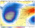
Kragg
Member
Models have trended towards under predicting moisture return in the SE the last few years. But, this far out I’m happy to say “don’t know” and shrug my shoulders.Overall downtrend in moisture return on the GFS.
View attachment 24399
- Moderator
- #954
From the SPC 4-8 day outlook:
There appears a general consensus among latest guidance that a
developing cyclone across the Texas/Oklahoma Panhandle vicinity,
trailing dryline southward into northwest Texas, and surface front
extending east-northeastward across Kansas into the lower Missouri
Valley could provide focus for organized severe thunderstorm
development Sunday afternoon into Sunday night. The cyclone may
then migrate northeastward along the front across the lower Missouri
Valley into the Upper Midwest Monday through Monday night,
accompanied by a potentially more widespread severe weather threat
across the southeastern Great Plains and lower/middle Mississippi
Valleys.
However, potential also exists for this to be considerably modulated
by cold air, initially banked up against the northern U.S. and
Canadian Rockies into much of the upper Mississippi Valley, which
may tend to nose further southward through the high plains prior to
the emergence of the primary short wave trough. Furthermore, in the
wake of an amplifying mid-level trough and associated cyclogenesis
still forecast offshore of the southern Atlantic Seaboard, low-level
moistening on southerly return flow off the Gulf of Mexico may not
be optimal.
Dixie be like: modulated threat my Gulf! Hold my tea!
- Thread starter
- #956
KevinH
Member
I mean…..Dixie be like: modulated threat my Gulf! Hold my tea!
CheeselandSkies
Member
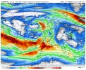
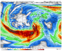
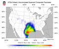
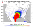
Week 2 and Week 3 CFS SCP
I'm afraid we're gonna pay the price with how quiet it's been.
Operational GFS remains stubbornly insistent that a low will form in the Gulf late this week and then move up the East coast, sweeping out the moisture and leaving only a couple of days for partial recovery ahead of the system early the following week. How that plays out is obviously going to be one of the keys to the ceiling of that threat. Definitely some concerning signals from other guidance despite the persistent thermodynamic issues on the GFS.
Is the GFS the only one showing that low pressure system?Operational GFS remains stubbornly insistent that a low will form in the Gulf late this week and then move up the East coast, sweeping out the moisture and leaving only a couple of days for partial recovery ahead of the system early the following week. How that plays out is obviously going to be one of the keys to the ceiling of that threat. Definitely some concerning signals from other guidance despite the persistent thermodynamic issues on the GFS.
CheeselandSkies
Member
Is the GFS the only one showing that low pressure system?
Hmmmm,...nope. Looks like Euro AIFS (which seems to have replaced the old hi-res Euro on Pivotal) has it, too.