
Navigation
Install the app
How to install the app on iOS
Follow along with the video below to see how to install our site as a web app on your home screen.
Note: This feature may not be available in some browsers.
More options
-
Welcome to TalkWeather! We see you lurking around TalkWeather! Take the extra step and join us today to view attachments, see less ads and maybe even join the discussion. CLICK TO JOIN TALKWEATHER
You are using an out of date browser. It may not display this or other websites correctly.
You should upgrade or use an alternative browser.
You should upgrade or use an alternative browser.
Severe Weather 2024
- Thread starter KevinH
- Start date
- Moderator
- #902
Severe Weather Threat 3/13-3/15/2024
Potential sequence coming up. Dates will probably need to be adjusted. Day 4-8 Convective Outlook NWS Storm Prediction Center Norman OK 0352 AM CDT Mon Mar 11 2024 Valid 141200Z - 191200Z ...DISCUSSION... Medium-range guidance is in good agreement that a deep, positively...
CheeselandSkies
Member
Interesting. It looks to me like the 06Z NAM backed off a bit (less focused surface low/weaker mass response and low-level shear) after being the main model supporting the higher ceiling event for the MW on Thursday starting when it first came into range at 12Z yesterday. Still merits continued monitoring, of course.
Gail
Member
Well this is frightening and makes me sick to my stomach. Preliminary tornado count thus far this year is 103 thru March 7th. There's only one year that is closest to it.....2011 (109)
Yeah......
Again I'm not trying to scare anyone, but I'm just pointing out facts and making you aware that we could be dealing with a much busier April than the last few years.
I also know a lot of people including myself continue to suffer from trauma and PTSD from that event.
Just hope for the best, but prepare for the worse

We picked a good year to get a shelter, I think.
Austin Dawg
Member
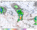
I know it's a voodoo land, but keep your eye on March 27 and 28th. the GFS is showing a big system starting in Texas and moving East It has a lot of.CAPE energy to tap in.
Gail
Member
Of course. It’s spring break week - we always have severe weather that week.I know it's a voodoo land, but keep your eye on March 27 and 28th. the GFS is showing a big system starting in Texas and moving East It has a lot of.CAPE energy to tap in.
Which just happens to be after the one year anniversary of the Amory, MS EF3 and passed near my house just a quarter mile away. Watch it happen during the Mississippi State Severe Storm Symposium. I registered for it last night so something is bound to happen to keep me from going. LOL!Euro with our next severe weather timeframe. Around or just after the 25th.
Ledian
Member
Not looking forward to dealing with that if it holds together...Euro with our next severe weather timeframe. Around or just after the 25th.
Mrgolfman7070
Member
The Jonesboro ar ef3 tornado end of March 2020 was live on kait going through the city. Missed my apt by quarter mileWhich just happens to be after the one year anniversary of the Amory, MS EF3 and passed near my house just a quarter mile away. Watch it happen during the Mississippi State Severe Storm Symposium. I registered for it last night so something is bound to happen to keep me from going. LOL!
GFS been somewhat consistent around this general timeframe though of course it is very far out. Early, early days, but the shape of the trough is quite concerning - GFS 18z was particularly nasty. Luckily plenty of time for things to calm down.Euro with our next severe weather timeframe. Around or just after the 25th.
Fully expect significant shifts in the GFS over the coming days, but the 12Z and 18Z had potentially concerning solutions for the South during the 26-28th time frame.GFS been somewhat consistent around this general timeframe though of course it is very far out. Early, early days, but the shape of the trough is quite concerning - GFS 18z was particularly nasty. Luckily plenty of time for things to calm down.
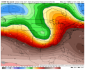
No thank you.CFS Week 2 SCP
Yeah.....No thank you.
That's a look, dang.Euro with our next severe weather timeframe. Around or just after the 25th.
Austin Dawg
Member
That brings us into play in central Texas. It's just about time for us to get a few nasty hailstorms.
Timhsv
Member
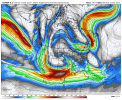
This is a WOW event if it holds. GFS 2nd run with this output of EHI and a possible multi-day event. This is from the 18Z GFS. The GFES isn't bouncing on it quite yet but the Euro is hinting at it at 300mb and 500mb.

CheeselandSkies
Member
This is a WOW event if it holds. GFS 2nd run with this output of EHI and a possible multi-day event. This is from the 18Z GFS. The GFES isn't bouncing on it quite yet but the Euro is hinting at it at 300mb and 500mb.
View attachment 24384
24 hours prior to that would be a highly potent (think almost exactly one year prior, and my avatar
") ) setup over the Midwest (left exit region of a 60+ kt 500mb jet, nearly 50kt LLJ and 989 mb surface low over Iowa) if only moisture weren't so paltry into the region (dewpoints in the 40s). However at this range I wouldn't put too much stock into it one way or the other. Certainly some interesting solutions showing up across multiple models, though.
) setup over the Midwest (left exit region of a 60+ kt 500mb jet, nearly 50kt LLJ and 989 mb surface low over Iowa) if only moisture weren't so paltry into the region (dewpoints in the 40s). However at this range I wouldn't put too much stock into it one way or the other. Certainly some interesting solutions showing up across multiple models, though.tennessee storm chaser
Member
- Messages
- 1,877
- Reaction score
- 4,288
- Location
- jackson tennessee
- Special Affiliations
- SKYWARN® Volunteer
Though still little out , some runs today are showing the most potent look I seen this far this 2024 seasonThis is a WOW event if it holds. GFS 2nd run with this output of EHI and a possible multi-day event. This is from the 18Z GFS. The GFES isn't bouncing on it quite yet but the Euro is hinting at it at 300mb and 500mb.
View attachment 24384