• Welcome to TalkWeather!
    We see you lurking around TalkWeather! Take the extra step and join us today to view attachments, see less ads and maybe even join the discussion.
    CLICK TO JOIN TALKWEATHER

Severe Weather 2024

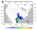
Even though the CFS has backed off on the SCP from yesterday, it's still showing a threat around that time. Honestly, it makes sense for a bigger threat around the late month timeframe. March 2024 (March 1st-16th): 36 (Weakening El Nino to Neutral ENSO/La Nina)

By the way here's how this March stacks up to the past 5 Marches tornado count wise:

March 2023 (March 1st-16th): 42 (Neutral ENSO to El Nino)
March 2022 (March 1st-16th): 49 (La Nina)
March 2021 (March 1st-16th): 30 (La Nina to Neutral ENSO)
March 2020 (March 1st-16th): 22 (Neutral ENSO)
March 2019 (March 1st-16th): 104 (Weak El Nino)
 

Attachments

  • cfs_week2 (1).png
    cfs_week2 (1).png
    184.9 KB · Views: 0
12z GFS delays system until 27th
12z Canadian around 26th
12z Euro around 26th
All global models have a severe weather look particularly the Euro. The Euro solution would prove to be a greater/more widespread risk with that tilt.
 

Attachments

  • ecmwf-deterministic-conus-z500_speed-1454400.png
    ecmwf-deterministic-conus-z500_speed-1454400.png
    235.4 KB · Views: 0
  • gem-all-conus-z500_speed-1454400.png
    gem-all-conus-z500_speed-1454400.png
    234.3 KB · Views: 0
  • gfs-deterministic-conus-z500_speed-1562400.png
    gfs-deterministic-conus-z500_speed-1562400.png
    226.8 KB · Views: 0
March 1st thru March 16th, 2024: 36 tornadoes

March 1st thru March 16th, 2011: 35 tornadoes

The amount of connections and teleconnections I've found or came across to 2011 thus far this year is very disturbing.
 
Despite some run-to-run changes, GFS continues to depict fairly potent setups towards the end of the month. Not putting any stock into it until it gets past 200 hours, but the consistency so far is rather impressive.
sbcape_hodo.us_se.pnggfs_2024031618_240_33.0--87.0.png
 
What are the other connections? :oops:
Well let's see.

1. January with the Deep South Winter Storm
2. Transition to La Nina
3. March Euro Seasonal with a similar 500mb pattern in April to 2011
4. California Tornado Warnings
5. The 5% Tornado Probability for Sacramento in February
6. When we had 3 tropical systems going at once in the Southern Hemisphere in February
Hmmmm…. We’ll see then
 
Well let's see.

1. January with the Deep South Winter Storm
2. Transition to La Nina
3. March Euro Seasonal with a similar 500mb pattern in April to 2011
4. California Tornado Warnings
5. The 5% Tornado Probability for Sacramento in February
6. When we had 3 tropical systems going at once in the Southern Hemisphere in February

I remember you had at least one connection to 1974, curious if you've seen any more.
 
Despite some run-to-run changes, GFS continues to depict fairly potent setups towards the end of the month. Not putting any stock into it until it gets past 200 hours, but the consistency so far is rather impressive.
View attachment 24390View attachment 24391

The 500mb setup on the 18Z run at FH240 (18Z 3/26) is the dreaded broad-based, practically full-longitude (of the CONUS) trough. Still voodoo land of course, but that's a heck of a look.
 
I remember you had at least one connection to 1974, curious if you've seen any more.
2 connections.

First was the winter weather event that Monroe County MS had during winter 74.

Second was the 500mb level pattern off the March Euro Seasonal for April. Similar to both 11 and 74.
 
Well let's see.

1. January with the Deep South Winter Storm
2. Transition to La Nina
3. March Euro Seasonal with a similar 500mb pattern in April to 2011
4. California Tornado Warnings
5. The 5% Tornado Probability for Sacramento in February
6. When we had 3 tropical systems going at once in the Southern Hemisphere in February


Amy Schumer No GIF by Saturday Night Live
 
One thing to consider when looking at the 3/25-3/27 time frame is the dewpoints in the Gulf leading up to the event. We'll have to keep an eye on the Mid level shortwave across the Southeast later this upcoming week as that may sweep the Gulf of the better moisture.

This system in the end of March will have to do a lot of work in a short amount of time to bring up the more robust moisture. I can post a comparison among the 00z models once the European model comes out.
Based off latest euro , that won’t be a problem ….we see how euro and rest models go toward that timeframe
 
One thing to consider when looking at the 3/25-3/27 time frame is the dewpoints in the Gulf leading up to the event. We'll have to keep an eye on the Mid level shortwave across the Southeast later this upcoming week as that may sweep the Gulf of the better moisture.

This system in the end of March will have to do a lot of work in a short amount of time to bring up the more robust moisture. I can post a comparison among the 00z models once the European model comes out.

Yes, I have observed that feature being the culprit for some of the limited moisture with the late month system seen on the runs yesterday. Today's 18Z appeared to be considerably weaker with it thus contributing to the much more eye-opening forecast soundings across a large area on the 26th.

*Edit: 00Z run is in and appears to have backtracked to sweeping the moisture out more. However, I wonder if it might not be overestimating the tendency to do that. It's not like you have a big Arctic high pressing down and scouring out the Gulf. The low pressure situation associated with that shortwave moves northeast up the Atlantic coast, so I'm not seeing how you'd get such a strong southward-crashing cold front with it. I may be totally off base, but something about this solution doesn't make sense to me.
 
Last edited:
Back
Top