
Insane 500mb look from the newest GFS run. Yowza
Navigation
Install the app
How to install the app on iOS
Follow along with the video below to see how to install our site as a web app on your home screen.
Note: This feature may not be available in some browsers.
More options
-
Welcome to TalkWeather! We see you lurking around TalkWeather! Take the extra step and join us today to view attachments, see less ads and maybe even join the discussion. CLICK TO JOIN TALKWEATHER
You are using an out of date browser. It may not display this or other websites correctly.
You should upgrade or use an alternative browser.
You should upgrade or use an alternative browser.
Severe Weather 2024
- Thread starter KevinH
- Start date
ashtonlemleywx
Member
Insane 500mb look from the newest GFS run. Yowza

And in all honesty looks to me like the 18z GFS is slower with multiple impulses rotating around. Signals a multi day threat. The actual front doesn't move thru until Friday.
Slow-movers have generally been some of the most memorable and significant events down here. Of course there's nothing to take away from one model run, but that would be quite the setup if it were to pan out. Absolute unit of a system.And in all honesty looks to me like the 18z GFS is slower with multiple impulses rotating around. Signals a multi day threat. The actual front doesn't move thru until Friday.

ashtonlemleywx
Member
I just don't think the low will break off the polar and subtropical jet like depicted in this interaction. Seems like a bad run to me.
- Moderator
- #686
Bad thing is, VBC in Huntsville will have an arena full of people next Wednesday night because AEW will be there filming a double show.
I gotta be like Twitter for a second lol. I'm loving these cringe weather takes. Had to make my own

TornadoFan
Member
Roses are red, the STP's a 10, This is May 3rd all over again.I gotta be like Twitter for a second lol. I'm loving these cringe weather takes. Had to make my own
View attachment 23957
And don't forget to DRIVE SOUTH!Roses are red, the STP's a 10, This is May 3rd all over again.
- Thread starter
- #690
KevinH
Member
I just looked at the dates on the loop and didn’t realize how slow it is…. That just by itself can’t be a good thingAnd in all honesty looks to me like the 18z GFS is slower with multiple impulses rotating around. Signals a multi day threat. The actual front doesn't move thru until Friday.
- Thread starter
- #691
KevinH
Member
AEW?Bad thing is, VBC in Huntsville will have an arena full of people next Wednesday night because AEW will be there filming a double show.
Weatherphreak
Member
I’m going to that. Gotta see Sting one last time. VBC is probably a pretty safe place to be.Bad thing is, VBC in Huntsville will have an arena full of people next Wednesday night because AEW will be there filming a double show.
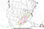
That's fairly impressive honestly.18z GFS CWASP
- Moderator
- #695
AEW?
All Elite Wrestling. My son is in the wrestling community and plans on being there.
- Moderator
- #696
I’m going to that. Gotta see Sting one last time. VBC is probably a pretty safe place to be.
That's why my son is going too.
ashtonlemleywx
Member

18z GFS has way more of a realistic depiction than the 12z run. Much closer to what we've been seeing out of the Euro. That 12z GFS run earlier was absurd and f*cking stupid.
CheeselandSkies
Member
View attachment 23960
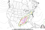
18z GFS has way more of a realistic depiction than the 12z run. Much closer to what we've been seeing out of the Euro. That 12z GFS run earlier was absurd and f*cking stupid.
I don't know about more realistic, but definitely more potent than some of these recent positively-tilted, squashed solutions. The surface response is still a little weird and not ideal for a tornado outbreak type of event. On Tuesday the main low is very deep but it's back over the Rockies with the moist sector waaaaaaay out ahead in SE OK/AR/SE MO and points east. On Wednesday there's a similar issue, although it appears there might be a secondary triple point setting up over far eastern Iowa/NW IL. Thursday might actually be the most impressive-looking day on this run but again that's still nearly 200 hours out.
Lots of potential here, but we still don't know much more than we did five days ago.
Last edited:
Bamamuscle
Member
Bad thing is, VBC in Huntsville will have an arena full of people next Wednesday night because AEW will be there filming a double show.
Ya know.. the last time AEW was in town for Dynamite there was severe weather!!
Sent from my iPhone using Tapatalk
ashtonlemleywx
Member
When I said more "Realistic"...I was referring to the 18z not being occluded backwards, reloading and bowling balling completely separate from the jet streak like the 12z did.I don't know about more realistic, but definitely more potent than some of these recent positively-tilted, squashed solutions. The surface response is still a little weird and not ideal for a tornado outbreak type of event. On Tuesday the main low is very deep but it's back over the Rockies with the moist sector waaaaaaay out ahead in SE OK/AR/SE MO and points east. On Wednesday there's a similar issue, although it appears there might be a secondary triple point setting up over far eastern Iowa/NW IL. Thursday might actually be the most impressive-looking day on this run but again that's still nearly 200 hours out.
Lots of potential here, but we still don't know much more than we did five days ago.
Even Stormchasernick poked fun at it.
