Almost at the 20 degree difference in dewpoints and temps lol. I've heard that becomes very unfavorable for tornadic storms when you got about a 20 or more difference. Lol or at least trey says thatGFS has been a little faster and further north with the threat. St. Louis area for Tuesday off the 18Z. 76/60 in February is nuts.
Navigation
Install the app
How to install the app on iOS
Follow along with the video below to see how to install our site as a web app on your home screen.
Note: This feature may not be available in some browsers.
More options
-
Welcome to TalkWeather! We see you lurking around TalkWeather! Take the extra step and join us today to view attachments, see less ads and maybe even join the discussion. CLICK TO JOIN TALKWEATHER
You are using an out of date browser. It may not display this or other websites correctly.
You should upgrade or use an alternative browser.
You should upgrade or use an alternative browser.
Severe Weather 2024
- Thread starter KevinH
- Start date


- Moderator
- #663
As expected there are quite a lot of different looks with the new runs. Plenty more of those to come especially with that cut off energy in the Pacific. Models aren’t going to handle that too well and the trend has been to slow its progression.
ashtonlemleywx
Member


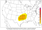
I wouldn't put too much emphasis on forecast models at this point. Point is a wide area from Texas to the Gulf Coast will see some severe weather threat next week. Whether or not it produces a big tornado event remains to be seen. And I'm gonna say this too while on the subject. The number of tornadoes produced should not be the only thing looked at for outbreak consideration. To me, damaging winds should also be considered as well. We in the meteorological community put way too much emphasis on the number of tornadoes produced or not during a severe outbreak.
ashtonlemleywx
Member
Honestly I get biggest thrill out of a big hail storm. December 9th, 2023 was wild.I wouldn't put too much emphasis on forecast models at this point. Point is a wide area from Texas to the Gulf Coast will see some severe weather threat next week. Whether or not it produces a big tornado event remains to be seen. And I'm gonna say this too while on the subject. The number of tornadoes produced should not be the only thing looked at for outbreak consideration. To me, damaging winds should also be considered as well. We in the meteorological community put way too much emphasis on the number of tornadoes produced or not during a severe outbreak.
ashtonlemleywx
Member


Yeah that looks rough. I dreamed last night that Monroe County saw a Tornado Emergency issued again. Hopefully it doesn't happen next week but given my dreams about tornadoes etc. tend to come true, it frightens me. Last year I dreamed that Aberdeen, MS and Starkville, MS got hit by tornadoes so there's that.
I know. I'm just full of Sunshine and Rainbows. LOL!
ashtonlemleywx
Member

- Thread starter
- #671
KevinH
Member
- Thread starter
- #672
KevinH
Member
Shocker! lolI know. I'm just full of Sunshine and Rainbows. LOL!
- Thread starter
- #673
KevinH
Member
If they consistently come true, make a YouTube channel and post about themYeah that looks rough. I dreamed last night that Monroe County saw a Tornado Emergency issued again. Hopefully it doesn't happen next week but given my dreams about tornadoes etc. tend to come true, it frightens me. Last year I dreamed that Aberdeen, MS and Starkville, MS got hit by tornadoes so there's that.

Yeah. I don't wanna become one of those people who think they time travel and see a category 6 hitting Florida or something though. LOL! Those people are probably on drugs or something.If they consistently come true, make a YouTube channel and post about them
tennessee storm chaser
Member
- Messages
- 1,877
- Reaction score
- 4,288
- Location
- jackson tennessee
- Special Affiliations
- SKYWARN® Volunteer
Klzk Little Rock nws starting sound bit bullish already on next weeks system , all forms severe weather look possible ….
- Thread starter
- #676
KevinH
Member
Bullish?Klzk Little Rock nws starting sound bit bullish already on next weeks system , all forms severe weather look possible ….
Yeah Kevin whenever a weather service office says bullish in their discussion, it means they have a live bull in their office. LOL! I'm kidding. Gotta pick on you sometimesBullish?
Here's their discussion on next week:
"Upper flow will become more zonal during the early part of the week
with several perturbations crossing the Rockies and supporting
persistent lee cyclogenesis. The resulting pressure gradient will
further increase Srly flow and associated thermal/moisture advection
locally with a broad warm sector established by Tues into Wed (for
reference, highs Tues afternoon will reach the upper 70s to low 80s
F for all of AR). A pronounced dryline to our W will serve as the
Wrn terminus of rich BL moisture.
While guidance has come into somewhat better agreement with the
21/12Z suite of data, confidence in fcst evolution remains low by
Tues/Wed. Broadly speaking, upper troughing should eject across the
central Plains midweek with a cold front accelerating SEwrd thru the
Plains as a strong sfc cyclone races towards the Great Lakes area.
This front is expected to overtake the dryline as it pushes E
towards AR.
Ample dynamic support along with strong deep-layer shear in excess
of 50 kts will be coupled with moderate instability across the warm
sector, and despite ongoing spatial and temporal discrepancies in
the guidance, concerns for severe weather remain given the
anticipated parameter space. Will await better model consensus
before hashing out specific threats, although strong/severe storms
with all hazards do appear possible somewhere within or near the
fcst area."
Meanwhile from MEG:
"A large upper-level trough will approach the area by
mid-week and interact with a warm and potentially unstable
atmosphere."
"A large upper-level trough will approach the area by
mid-week and interact with a warm and potentially unstable
atmosphere."