
Navigation
Install the app
How to install the app on iOS
Follow along with the video below to see how to install our site as a web app on your home screen.
Note: This feature may not be available in some browsers.
More options
-
Welcome to TalkWeather! We see you lurking around TalkWeather! Take the extra step and join us today to view attachments, see less ads and maybe even join the discussion. CLICK TO JOIN TALKWEATHER
You are using an out of date browser. It may not display this or other websites correctly.
You should upgrade or use an alternative browser.
You should upgrade or use an alternative browser.
Severe Weather 2024
- Thread starter KevinH
- Start date

tennessee storm chaser
Member
- Messages
- 1,877
- Reaction score
- 4,288
- Location
- jackson tennessee
- Special Affiliations
- SKYWARN® Volunteer
Very impressive. The trough itself00Z GFS depiction so far.
View attachment 23962
- Moderator
- #703
The GFS point soundings thus far have lacked SARS analog matches.
tennessee storm chaser
Member
- Messages
- 1,877
- Reaction score
- 4,288
- Location
- jackson tennessee
- Special Affiliations
- SKYWARN® Volunteer
Not sure what think bout that. Be honestThe GFS point soundings thus far have lacked SARS analog matches.

CheeselandSkies
Member
Bold move by SPC given recent model variability, with large areal highlights for Day 6-7. However I do need to keep in mind they highlight for general severe potential and not tornado outbreaks specifically.
- Thread starter
- #707
KevinH
Member
There is now a thread for next weekBold move by SPC given recent model variability, with large areal highlights for Day 6-7. However I do need to keep in mind they highlight for general severe potential and not tornado outbreaks specifically.
Severe Threat - Feb 27-28th, 2024
Gonna go ahead and make a thread early. Both Euro and GFS depict some type of severe event during these days. CIPS analogs are also lighting up.
tennessee storm chaser
Member
- Messages
- 1,877
- Reaction score
- 4,288
- Location
- jackson tennessee
- Special Affiliations
- SKYWARN® Volunteer
Yeah. But this one has legs …. Seeing some data putting out instability u see Kate April …. Actually gfs n euro been pretty consistent showing this large wicked trough negative titledBold move by SPC given recent model variability, with large areal highlights for Day 6-7. However I do need to keep in mind they highlight for general severe potential and not tornado outbreaks specifically.
Gail
Member
We finally had our tornado shelter installed on Valentine’s Day. I hope we don’t have to use it next week!


MEG in morning discussion says severe weather isn't expected even though we're under a Marginal Risk for Severe Storms.
[FONT=lucida sans typewriter, lucida console, courier]RAIN CHANCES LOOK TO INCREASE MID MORNING AND THUNDER CHANCES
INCREASE LATE AFTERNOON. SEVERE WEATHER IS NOT EXPECTED, BUT A FEW
OF THE STORMS COULD BE STRONG. CAPE LOOKS TO CAP OUT AT 500 J/KG OR
LESS, BUT AN UNSTABLE AIR MASS WITH UPPER 50S AND LOW 60S DEWPOINTS
AIDED BY MODERATE WIND SHEAR, COULD ALLOW FOR SMALL HAIL AND[/FONT]
This is a certified MEG classic.MEG in morning discussion says severe weather isn't expected even though we're under a Marginal Risk for Severe Storms.
[FONT=lucida sans typewriter, lucida console, courier]RAIN CHANCES LOOK TO INCREASE MID MORNING AND THUNDER CHANCES
INCREASE LATE AFTERNOON. SEVERE WEATHER IS NOT EXPECTED, BUT A FEW
OF THE STORMS COULD BE STRONG. CAPE LOOKS TO CAP OUT AT 500 J/KG OR
LESS, BUT AN UNSTABLE AIR MASS WITH UPPER 50S AND LOW 60S DEWPOINTS
AIDED BY MODERATE WIND SHEAR, COULD ALLOW FOR SMALL HAIL AND[/FONT]
Some hints at a bigger severe weather potential in early March generally in the 3/4-3/5 timeframe over the S Plains and Mid South/SE. Strong signal in the EPS for synoptic scale troughing across the western/central CONUS during that time as a powerful northern stream jet streak amplifies. One fly in the ointment would be how the sub-tropical (southern branch) jet evolves following Tuesday/Wednesday's system. That could result in a lack of ridging/high pressure over the Gulf/SE and stunt moisture return. With that said, the 12z EPS was an improvement over the 00z run in that respect.
- Moderator
- #714
Things have improved to the point where there’s now a signal for maybe severe weather somewhere and of some level this period. But models are all over the place with this next trough ejection. Ha ha.
Last edited:
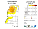
In other news, the drought has improved significantly for MS though parts of the Northwest MS are still in Severe Drought.
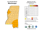
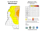
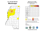
The most recent February's where all of MS or portions of MS were in Severe Drought:
2011
2017
2021
U.S. tornado average in March is 89 (1998-2022)
March 2011: MS had 6 tornadoes (Nationwide had 75 tornadoes)
March 2017: MS had 3 tornadoes (Nationwide had 158 tornadoes)
March 2021: MS had 20 tornadoes (Nationwide had 144 tornadoes)
With the exception of 2021, April was very active with tornadoes.
ENSO Forecast in February 2011: a weakening La Nina transitioning towards Neutral
ENSO Forecast in February 2017: Neutral conditions (that ended up going to La NIna)
ENSO Forecast in February 2021: La Nina trending towards Neutral
By the way, as of February 23rd, we've had 70 tornadoes nationally. The 3 closest years that had around or just over 70 tornadoes by this time are: A. 1990, B. 2005, and C. 2011
Attachments
tennessee storm chaser
Member
- Messages
- 1,877
- Reaction score
- 4,288
- Location
- jackson tennessee
- Special Affiliations
- SKYWARN® Volunteer
When will our next big severe wx threat be for the south is the million dollar question …. I’m bout get in patient here lol
CheeselandSkies
Member
That early March system about 8-9 days out would be the next one to watch. Today's 12Z GFS has it blowing way north through the Midwest with 50s dewpoints almost to Canada (on March 4th!) again but there are some problems. The trough is a little more pinched than I would like, want to see it broader based E-W with the flow in the exit region not so meridional. But, it's just one run and as we just saw things can go either way at this range.
How it's felt so far this year watching model data change drastically every other run.That early March system about 8-9 days out would be the next one to watch. Today's 12Z GFS has it blowing way north through the Midwest with 50s dewpoints almost to Canada (on March 4th!) again but there are some problems. The trough is a little more pinched than I would like, want to see it broader based E-W with the flow in the exit region not so meridional. But, it's just one run and as we just saw things can go either way at this range.
Timhsv
Member
WHOA......

CheeselandSkies
Member
Yeah, although the timing is about a day faster now, that trough also looks a lot more impressive on the GFS than it did 24 hours ago. At least as depicted on today's 12Z run, today/tomorrow's system doesn't scour the Gulf too badly, either. Interesting times ahead.