- Thread starter
- #1,581
KevinH
Member
Oh12Z Euro hasn't come in yet. Not much else I really pay attention to at this range.
Follow along with the video below to see how to install our site as a web app on your home screen.
Note: This feature may not be available in some browsers.
Oh12Z Euro hasn't come in yet. Not much else I really pay attention to at this range.
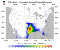
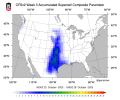
Juicy air across LA, MS, and AL there.Meanwhile CFSv2 week 1 SCP and 00z Euro Dewpoints for Friday.
That is moist.Meanwhile CFSv2 week 1 SCP and 00z Euro Dewpoints for Friday.
Kind of on par with what the SPC saidSnippet from NWS Jackson Afternoon Discussion:
"Wednesday night through Thursday, there is a chance for an
additional shot at rain as remnant energy from Eastern Pacific
Tropical Storm (soon-to-be Hurricane) Lidia will be dissipating over
northern Mexico and becoming absorbed in the Westerlies. Warm, humid
air expanding farther north from the Gulf Coast will support at
least a slight chance for some thunderstorms during this time.
Finally, a low pressure system moving east across the U.S. will
usher a cold front through our forecast area Friday into Friday
night. Modest deep-layer wind shear and weak instability are
currently expected, but a little more warming or moistening of the
atmosphere could support a slight chance for severe storms with that
front. There`s been too much variability in the guidance at this
point to advertise any severe threat, but it`s worth watching as we
make the transition into the cool season."
.png")
.png")

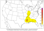
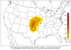
You can’t see why no one mentioned this? lolIntroducing quite possibly the smallest day 4 outlook ever... ta da View attachment 21792
Already?Also the NAM is predicting a robust gulf threat. A thread is warranted. Booting up a thread
From landfall of tropical low. I'll incorporate the inland severe threat into the day 4 threat as well.Already?
Bruh, too soon lolFrom landfall of tropical low. I'll incorporate the inland severe threat into the day 4 threat as well.
Thread 'Severe threat 10/11 - 10/14' https://talkweather.com/threads/severe-threat-10-11-10-14.2196/

@JPWX have these changed at all for this time period?
Lol I thought it was good timing, usually whenever a threat is In the day 4-8 range by spc a thread gets made lolBruh, too soon lol
The SPC barely has any slight risks highlighted over the next three days and they aren’t too confident about D4-8 either due to lack of instability