• Welcome to TalkWeather!
    We see you lurking around TalkWeather! Take the extra step and join us today to view attachments, see less ads and maybe even join the discussion.
    CLICK TO JOIN TALKWEATHER

Severe Weather 2023

Thank you.

Yeah can’t say I’m a fan of THAT :oops: 
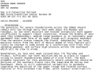
. I don’t understand these all that well BUT it looks like a low (bc of the lines close together lol) coming through Dixie. Looks like it COULD be… uh.. ACTIVE
Not sold on a big event as of now, but I would say a look like this might bring some severe weather somewhere in the Southeast
 
Latest Day 4 thru 8 discussion from SPC:
 

Attachments

  • 202310060856_SWOD48.png
    202310060856_SWOD48.png
    39 KB · Views: 0
What does this look like NOW? @JPWX
Still in good shape. SPC is beginning to hint at a severe weather threat late next week timeframe (12th to 14th). I'm not relying on the forecast models yet as they are still all over the place but just on my gut instincts. The CIPS analog guidance is also hinting at a increase.
 
LONG TERM...
(Monday night through Thursday)
Issued at 324 AM CDT Fri Oct 6 2023

Southwesterly low level flow sets up in earnest and strengthens
Wednesday night into the weekend. This may take us back to a more
active convective and rainfall pattern. Models hint at maybe some
stronger storms sometimes over the weekend, but models are quite
different on when that might occur exactly right now.
 
Newest GFS run is rather intriguing. Low/Mid cape and shear event. Rather zonal.

Not overly impressed by the setup, I think the highest chance for severe weather will be closest to the Gulf or southern half of the Southeast.
 
Last edited:
Newest GFS run is rather intriguing. Low/Mid cape and shear event. Rather zonal.

Not overly impressed by the setup, I think the highest chance for severe weather will be closest to the Gulf or southern half of the Southeast.
That's usually how it works during El Nino, but that's not always the case.
 
Still in good shape. SPC is beginning to hint at a severe weather threat late next week timeframe (12th to 14th). I'm not relying on the forecast models yet as they are still all over the place but just on my gut instincts. The CIPS analog guidance is also hinting at an increase.
I have noticed the slight uptick as well.

Too early to create a thread though hahahahahaha
 
Newest GFS run is rather intriguing. Low/Mid cape and shear event. Rather zonal.

Not overly impressed by the setup, I think the highest chance for severe weather will be closest to the Gulf or southern half of the Southeast.
That’s what the CIPS that someone posted said as well.

Will be interesting to see how things evolve in the coming days.
 
Back
Top