
Navigation
Install the app
How to install the app on iOS
Follow along with the video below to see how to install our site as a web app on your home screen.
Note: This feature may not be available in some browsers.
More options
-
Welcome to TalkWeather! We see you lurking around TalkWeather! Take the extra step and join us today to view attachments, see less ads and maybe even join the discussion. CLICK TO JOIN TALKWEATHER
You are using an out of date browser. It may not display this or other websites correctly.
You should upgrade or use an alternative browser.
You should upgrade or use an alternative browser.
Severe Weather 2023
- Thread starter KevinH
- Start date

TH2002
Member
- Messages
- 4,974
- Reaction score
- 11,116
- Location
- California, United States
- Special Affiliations
- SKYWARN® Volunteer
00z HRRR forecasted sounding near the MO/southern IL border. Can we not?

Here's the damage reports. @Austin Dawg 60mph straight line winds. The Severe Thunderstorm Warning from Memphis issued at 1:11pm had a observed tag on the wind threat.
Attachments
TH2002
Member
- Messages
- 4,974
- Reaction score
- 11,116
- Location
- California, United States
- Special Affiliations
- SKYWARN® Volunteer
40/20 Tornado Watch up.00z HRRR forecasted sounding near the MO/southern IL border. Can we not?
View attachment 21254
Storm Prediction Center Tornado Watch 597
Severe weather, tornado, thunderstorm, fire weather, storm report, tornado watch, severe thunderstorm watch, mesoscale discussion, convective outlook products from the Storm Prediction Center.
www.spc.noaa.gov
Oh, and we already have Tornado Warnings popping up. Yikes.
Tornado Warning
ILC009-062115-
/O.NEW.KLSX.TO.W.0029.230806T2027Z-230806T2115Z/
BULLETIN - EAS ACTIVATION REQUESTED
Tornado Warning
National Weather Service St Louis MO
327 PM CDT Sun Aug 6 2023
The National Weather Service in St Louis has issued a
* Tornado Warning for...
Northeastern Brown County in west central Illinois...
* Until 415 PM CDT.
* At 327 PM CDT, a severe thunderstorm capable of producing a tornado
was located over Mount Sterling, moving east at 20 mph.
HAZARD...Tornado.
SOURCE...Radar indicated rotation.
IMPACT...Flying debris will be dangerous to those caught without
shelter. Mobile homes will be damaged or destroyed.
Damage to roofs, windows, and vehicles will occur. Tree
damage is likely.
* This tornadic thunderstorm will remain over mainly rural areas of
northeastern Brown County, including the following locations... La
Grange, Coopertown, and Ripley.
PRECAUTIONARY/PREPAREDNESS ACTIONS...
TAKE COVER NOW! Move to a basement or an interior room on the lowest
floor of a sturdy building. Avoid windows. If you are outdoors, in a
mobile home, or in a vehicle, move to the closest substantial shelter
and protect yourself from flying debris.
&&
LAT...LON 4005 9068 4005 9066 4003 9065 4002 9063
4003 9061 4001 9062 4000 9060 3998 9060
3999 9051 3997 9051 3995 9053 3991 9055
3993 9071 4004 9075 4006 9068
TIME...MOT...LOC 2027Z 277DEG 16KT 3998 9076
TORNADO...RADAR INDICATED
MAX HAIL SIZE...<.75 IN
$$
Carney
- Moderator
- #1,305
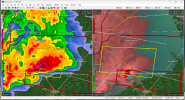
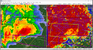
We have an interesting circulation south of New Berlin, IL.
TH2002
Member
- Messages
- 4,974
- Reaction score
- 11,116
- Location
- California, United States
- Special Affiliations
- SKYWARN® Volunteer

- Moderator
- #1,307
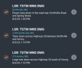
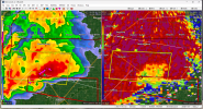
Multiple reports of a tornado on that storm.
CheeselandSkies
Member
- Moderator
- #1,309
Strong tornado on the ground. Big cc drop.
- Moderator
- #1,310
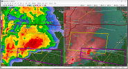
At 6:26 there was a confirmed wedge. At 6:30 NWS updates warning to say confirmed.
- Moderator
- #1,311
Unfortunately, looks like it hit houses.
TH2002
Member
- Messages
- 4,974
- Reaction score
- 11,116
- Location
- California, United States
- Special Affiliations
- SKYWARN® Volunteer
May have clipped the northern edge of Taylorville, which was hit by an EF3 back in December 2018

I'm probably not alone welcoming snow at this point. What a prolonged severe season that isn't showing any signs of slowing down.
CheeselandSkies
Member
I'm probably not alone welcoming snow at this point. What a prolonged severe season that isn't showing any signs of slowing down.
NAM says Wednesday could go big over the same areas getting hit today.
TH2002
Member
- Messages
- 4,974
- Reaction score
- 11,116
- Location
- California, United States
- Special Affiliations
- SKYWARN® Volunteer
Watch out. We all know what Ohio likes to do with marginal setups like this.
Storm Prediction Center Mesoscale Discussion 1871
Severe weather, tornado, thunderstorm, fire weather, storm report, tornado watch, severe thunderstorm watch, mesoscale discussion, convective outlook products from the Storm Prediction Center.
www.spc.noaa.gov
TH2002
Member
- Messages
- 4,974
- Reaction score
- 11,116
- Location
- California, United States
- Special Affiliations
- SKYWARN® Volunteer
Tornado Watch 598 is out for southern Indiana and parts of northern KY including the Louisville metro. Unfortunately, as 2023's tradition goes the Evansville Radar has in fact been infected with the contagious disease known as Radarus Inoperabilius, and is non-functional at the worst possible time.
000 NOUS63 KPAH 042201 FTMVWX Message Date: Aug 04 2023 22:01:04 KVWX RADAR WILL REMAIN DOWN UNTIL THE PART ARRIVES FOR THE POWER SUPPLY ISSUE. R ESTORATION TIME IS UNKNOWN AT THIS TIME.
TH2002
Member
- Messages
- 4,974
- Reaction score
- 11,116
- Location
- California, United States
- Special Affiliations
- SKYWARN® Volunteer
Probably A QLCS tornado ongoing near Cuzco, IN
tennessee storm chaser
Member
- Messages
- 1,877
- Reaction score
- 4,288
- Location
- jackson tennessee
- Special Affiliations
- SKYWARN® Volunteer
Wednesday starting to perk my interest more n more …. Look for a rather large enhanced risk coming in later updates , for august the shear isn’t bad for Ozarks over to the midsouth region….